
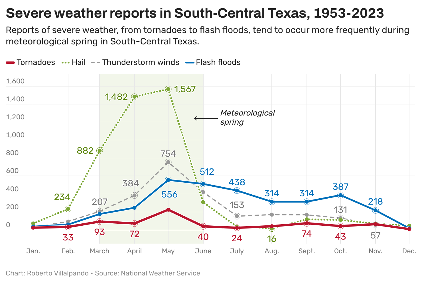
Atmospheric moisture from the Gulf of Mexico increases and clashes with dueling dry air masses, triggering more frequent rounds of rain and thunderstorms. And that’s just the beginning.
“Severe weather season is here and will increase through May,” said Mack Morris, a climate meteorologist with the National Weather Service office for Austin and San Antonio, during a spring climate briefing Monday. “May typically brings the highest risk for hail, damaging winds, and tornadoes. It is also the wettest month of the year, so the threat of flash flooding increases.”
We are only a few days into the new month, but it’s been pretty tranquil: morning clouds, afternoon sunshine, breezy winds and above-normal temperatures in the 80s.
The short-term forecast calls for similar weather Tuesday, with morning clouds and early temperatures in the 60s, followed by a partly cloudy sky in the afternoon, gusty south winds and peak temps in the middle to upper 80s.
The long-term forecast is where our quiet and predictable weather pattern will drastically shift. Our recent stretch of dry weather will give way to heavy rainfall and the growing possibility of severe weather later this week and the upcoming weekend.
The ridge of high atmospheric pressure that dominated our weather during the last week of February will finally move east. This will allow a cold front to move into the Lone Star State, but not before losing momentum and stalling across the region. This will be the focal point for the first round of rain midweek.
At the same time, an upper-level system of low pressure out west will steer several atmospheric disturbances into Texas over the next week or so. That’s why the weather service’s Storm Prediction Center has placed parts of Texas under a threat of severe weather through the weekend.
We will initially see rain and thunderstorms beginning Wednesday, with the axis of heavy rainfall and strong storms just north of Austin. Still, we’ll maintain a 30-40% chance of storms in Central Texas. Thursday will be dry, and then rain chances ramp up again Friday and will continue through the weekend.
“Since we remain in a very moist environment with modest (atmospheric) instability, any storms that do form could produce heavier rainfall,” weather service meteorologists wrote in a forecast discussion posted online Monday. “The caveat right now is there is very high uncertainty how this all unfolds as models are still all over the place and will likely remain that way until we get closer.”
What is more concrete is that forecast temperatures will continue to be 10 to 15 degrees warmer than our early-March average maximum temp of 70 degrees for the rest of the week and upcoming weekend.