A Weather Impact Alert has been issued for the Houston area as storms on Saturday into Sunday could be severe.
HOUSTON — A weather system moving into Southeast Texas this weekend could bring rain, thunderstorms and the potential for isolated severe weather.
Chief Meteorologist David Paul said a Weather Impact Alert is in effect for Saturday evening, and storms could last well into Sunday morning. Below is a detailed timeline of what you can expect, as of Thursday night.
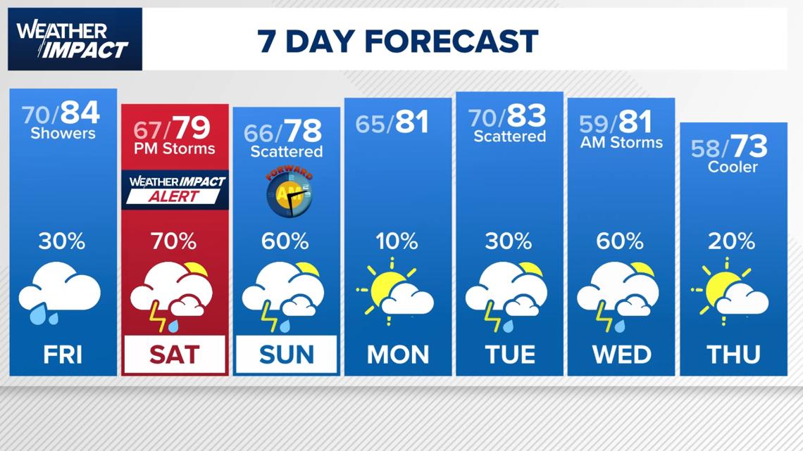
Friday
Morning
A few light streamer showers may develop as moisture streams in from the Gulf.Rain would mainly be sprinkles to light rain that doesn’t last long.Cloudy, warm and humid start to the day with morning temperatures around the low 70s.
Afternoon
Overall warm and breezy conditions with a high near 84 degrees.Only a 30% chance of isolated showers, and forecasters say even that may be overdone.Most areas expected to stay dry.

Saturday
Morning
A few isolated streamer showers possible early in the morning.Otherwise, it’ll be warm, humid and breezy.
Afternoon
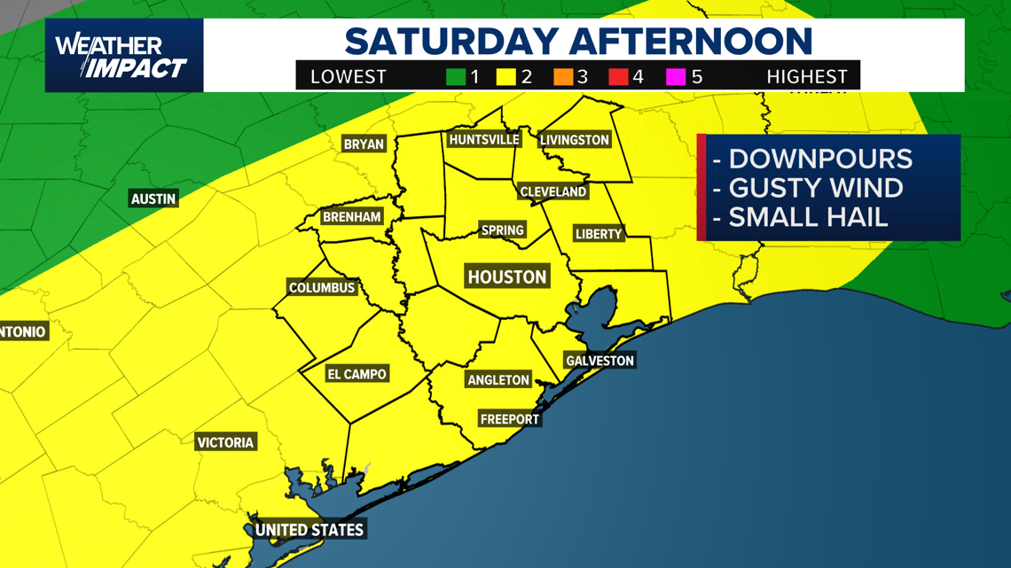
Forecast models suggest little to no significant rain during the day.Scattered showers may develop well north of Houston by late afternoon, but the metro area could remain mostly dry.Conditions may still be favorable for outdoor plans earlier in the day.
Evening and Overnight
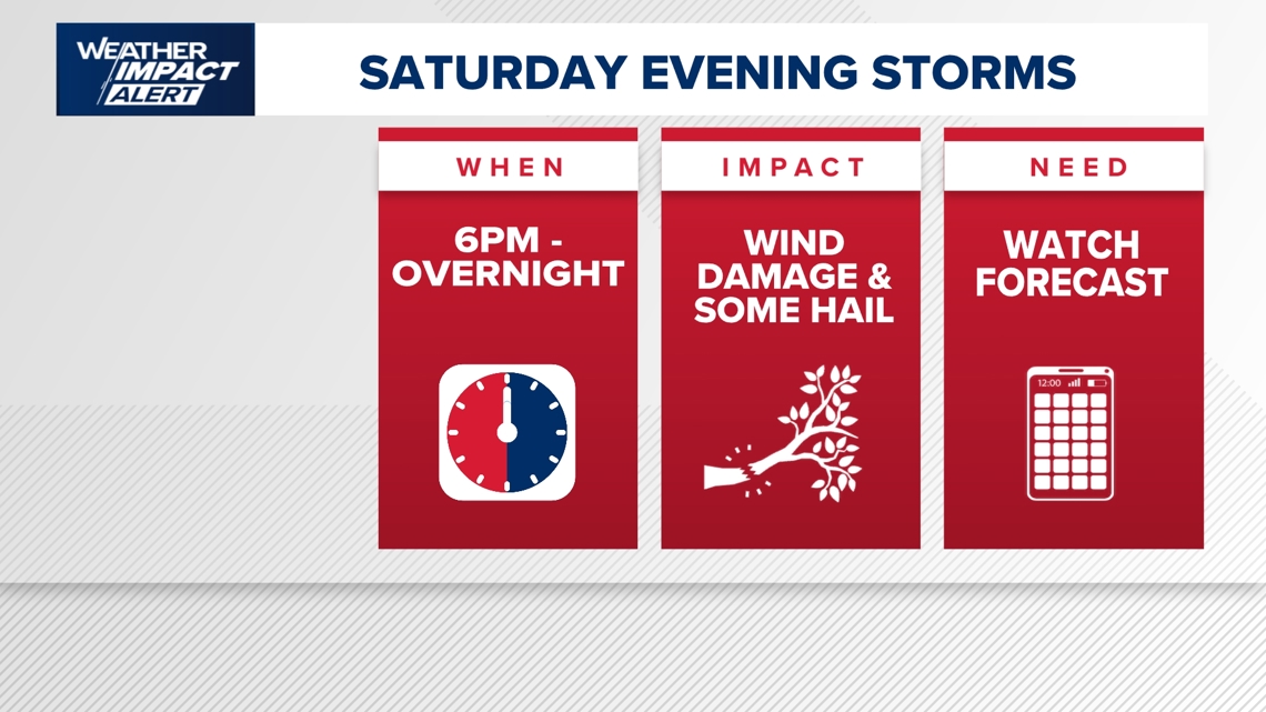
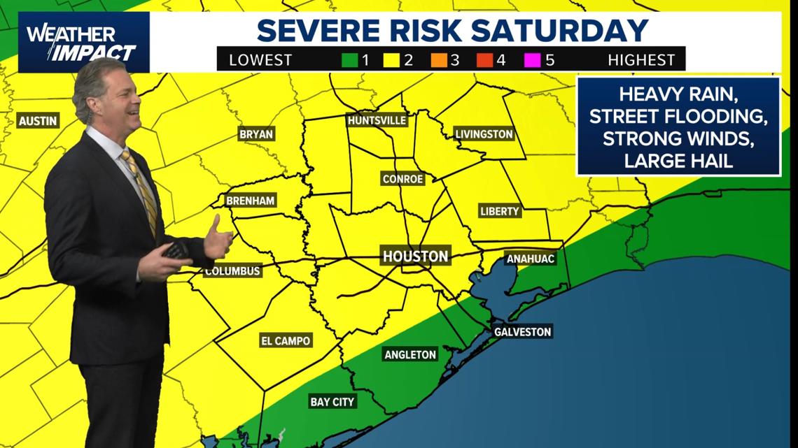
Weather Impact Alert begins around 6 p.m.A stalled front and upper-level disturbance could trigger thunderstorms late Saturday night.Some storms may be severe, with threats including:Damaging straight-line winds possibly 60–70 mph or higherLarge hailBrief heavy rainfall that could cause street pondingA low chance of an isolated tornado

Sunday
Morning
A line of thunderstorms could move through around sunrise, with strong storms possible in parts of the region.The main batch of storms may push through by around 9 a.m.
Afternoon
The front is expected to stall instead of moving offshore, keeping conditions unsettled.Scattered showers and storms possible off and on throughout the day.Rain chances around 60%.
Rainfall outlook
Most of the Houston area could see 1 to 2 inches of rain through early Monday.Some isolated locations could receive 3 to 4 inches, which could cause street ponding or localized flooding, though widespread flooding of creeks and bayous is not expected.
Looking ahead
Another spring storm system could bring rain chances Tuesday and especially Wednesday, with the potential for additional strong storms.After that system passes, cooler temperatures are expected late next week.
Forecasters say the exact timing of the weekend storms could still change, and updates are likely as new data comes in.
What this means for weekend plans
The timing of the storms could impact Saturday afternoon and evening activities, including trips to the Houston Livestock Show and Rodeo, travel around the city, or visits to Galveston.
Heavy rain could reduce visibility and create slick road conditions during peak travel hours.
Looking ahead
Before the weekend storms arrive, Southeast Texas will see breezy conditions with clouds and occasional sunshine.
Earlier fog reduced visibility in some areas, but conditions have improved.
The KHOU 11 Weather Team will continue monitoring the system as it approaches, especially for any changes in storm timing or rainfall totals heading into Saturday.