
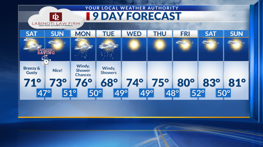
EL PASO, Texas (KTSM) — Happy Friday, Borderland! After a series of breezy and gusty days, the Sun City will see relief on Sunday. The nice weather won’t last for long, though, with rain and more wind following shortly after.
For Friday night, winds will calm to be light and variable around 5-10 mph. The sky will be partly cloudy with a low around 45.

Another breezy and gusty day is ahead for Saturday. Winds blowing around 10-15 mph in the afternoon with some clouds. Gusts will upwards of 25 mph. The high will be around 70. The overnight low will be around 47.
You may want to think about getting to bed early Saturday night with daylight saving time springing us forward – meaning we lose an hour of sleep.
On the bright side, Sunday’s weather will make up for the hour lost with nice spring-like conditions. Expect mostly sunny skies and a high in the low 70s. The low will be in the lower 50s.
Temperatures warm up near the mid 70s on Monday with rain chances on the board. The winds will be blowing on the lighter side around 5-10 mph. Those speeds picking up in the evening to 10-15 mph, gusts around 20 mph. The low will be around 50.
Greater rain shower chances present themselves Tuesday with a high in the upper 60s. The low will be in the upper 40s.
On Wednesday forward, moisture drops with sunny skies prevailing throughout the week into the weekend. High temperatures will gradually increase into the low 80s through the weekend, with lows consistently in the upper 40s to low 50s.
Copyright 2026 Nexstar Media, Inc. All rights reserved. This material may not be published, broadcast, rewritten, or redistributed.
For the latest news, weather, sports, and streaming video, head to KTSM 9 News.