
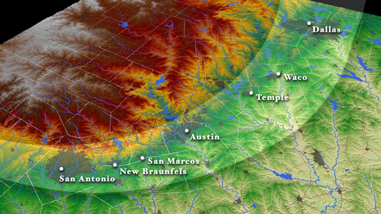
“Flash Flood Alley” is a term used for cities along the Balcones Escarpment in Texas where flooding is common.
National Weather Service
Texas has 15 major rivers and 3,700 named streams, many running through Central and South Texas, making the state one of the most flood-prone regions in the United States, according to the Texas Parks and Wildlife Department. That’s why a huge swath of the state has been given the name “Flash Flood Alley.”
Flash Flood Alley follows the curve of the Balcones Escarpment from Dallas to Austin and then extends just southwest of San Antonio. The escarpment is not only the eastern edge of the Edwards Plateau and the Hill Country, it’s also the natural boundary between the semi-arid higher elevations that stretch into West Texas and the humid Coastal Plains leading to the Gulf of Mexico.
Article continues below this ad
Texas has a unique natural combination of volatile weather patterns and a varied landscape to produce rapid-onset floods. It’s partly why flash flooding is the state’s leading cause of weather-related deaths, according to the National Weather Service.
Austin Fire Department rescue personnel secure a low water crossing entrance over Williamson Creek on Oct. 24, 2015, in Austin.
Ralph Barrera/Associated Press
Why does Flash Flood Alley exist?
Several factors contribute to this nickname, said Chris Morris, a meteorologist at the regional National Weather Service office for Austin.
Article continues below this ad
“When storms occur in our area, they can convert the abundant supply of atmospheric moisture from both the Gulf of Mexico and the Pacific Ocean into rainfall, which can be torrential at times,” Morris explained.
The hilly terrain of the Balcones Escarpment provides the air flow with extra vertical lift, which helps with storm development. The region’s rocky, clay-rich, shallow soils also limit infiltration, so rain quickly becomes runoff into streams and rivers.
Beyond natural factors, human-made ones matter, too: Rapid urban growth along the Interstate 35 corridor and the replacement of green space with pavement reduce the ground’s ability to absorb heavy rainfall, increasing the risk of major flash flooding in this region.
“We have the hills, the subsoil limestone layer, then we drop heavy rain on it,” said longtime Austin weather forecaster Troy Kimmel, a senior lecturer at the University of Texas. “Now, not only is the limestone going to create runoff, but the hills are going to cause it to double- and triple-speed when it does.”
Article continues below this ad
Residents attempt in vain to tether their truck in a low water crossing in a an area just off Highway 21 near Cedar Creek as Hurricane Harvey hits the countryside east of San Antonio on August 27, 2017.
Tom Reel/San Antonio Express-News
According to the National Oceanic and Atmospheric Administration’s storm database, more than 200 flash flood events have been recorded in Travis County since 2000, and they have accounted for 125 million dollars in property damage.
Nationwide, the 30-year average is about 127 flash flood deaths per year, and roughly half are vehicle-related, according to the National Weather Service.
Preparedness and Planning is Key
The time to prepare for severe weather is now. Flash flooding can happen year-round, but the odds are highest in spring and fall, when clashing air masses and changing seasons bring turbulent weather.
Article continues below this ad
RARE JULY FLOODS: A timeline of the flooding that ravaged Central Texas in July
The weather service urges the public to have multiple ways of receiving critical weather warnings such as cellphone alerts, weather apps, weather radios and television, Morris said.
“Develop a severe weather safety plan that covers where you and your family will safely shelter for the different types of severe weather hazards,” Morris suggested.
Knowing how to spot your vulnerability to flooding also should be a priority. For example, on a sunny day in the Hill Country, you may notice a low water crossing that has nothing flowing in it or only a trickle of water. But understand that when it does rain heavily, the water crossing can become full extremely quickly and may overflow its banks.
Article continues below this ad
Joel Sierra, 18, is rescued by San Antonio Fire Department personnel after attempting to drive through a low water crossing on Pinn Road near Texas 151 on April 21, 2023.
Jerry Lara/San Antonio Express-News
“People are building in more dangerous places,” Kimmel warned. “In the Hill Country, they like the scenic views, but they have three low water crossings that separate them from the nearest town. Unfortunately, it causes people to take more chances.”
Here are a few tips when faced with flooding:
Article continues below this ad
Do not camp or park in areas subject to flooding, such as dips, low spots, canyons, creek beds, and washes. If flooding occurs, move quickly to higher ground.
Avoid flooded areas, especially where water is flowing quickly. Roadbeds may be severely damaged or completely washed out under floodwaters. Most vehicles can become difficult to control in as little as six inches of water and can be swept away in two feet of water.
Be extremely cautious at night when it is harder to recognize the extent of flooding. If you are unsure, follow the safety slogan: “Turn Around, Don’t Drown.”
You can use online trackers to identify low water crossings at risk of flooding. Atxfloods.com monitors thousands of these roads and their maps show which crossings are closed when the water gets too high.