
Another round of strong and potentially severe thunderstorms is expected Saturday as a cold front approaches North Texas. Storms will be ongoing through the morning.
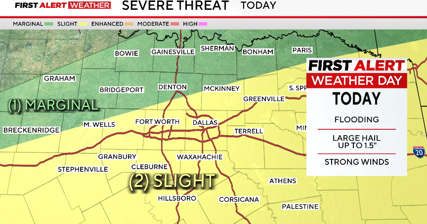
The Storm Prediction Center has highlighted a scattered risk, level 2 out of 5, for severe storms. The main risks will be large hail and damaging winds; however, an isolated tornado is still a possibility. The storms and heavy rainfall will also lead to flooding concerns.

This weekend, rain totals will be around 1-2 inches with localized heavier totals of 3+ inches.
The timing of the strongest activity looks to be before 11 a.m. for most of North Texas. For those to the southeast of DFW, strong storms may continue through 2 p.m.


As for temperatures, the high of the day will be in the morning, with temperatures rapidly decreasing throughout the day. Temperatures should be in the 60s by Saturday afternoon, with wind gusts up to 25 mph
Sunday will be mainly sunny and dry. The day will start cool and seasonal with temperatures in the upper 40s, and a high of 72 in the afternoon. The stalled front may cause a few showers and storms south of I-20. There is an isolated chance of severe storms in eastern Texas.
Looking ahead to next week, a few isolated non-severe storms on Monday before another round of severe weather returns on Tuesday and Wednesday. As of now, there is a slight risk on Tuesday and Wednesday due to an upper-level low and surface front.
A First Alert Weather Day is in effect for Tuesday and Wednesday for the threat of hail, damaging winds, flooding and even an isolated tornado.

Nice weather returns mid-week and continues through the weekend.
