
A potent storm system is bringing a heightened risk of flooding to areas north and west of Houston on Friday. Heavy rainfall and gusty winds are expected this weekend across Southeast Texas.
How much rain could fall across Texas? Which day this weekend will Houston have the highest flood risk?
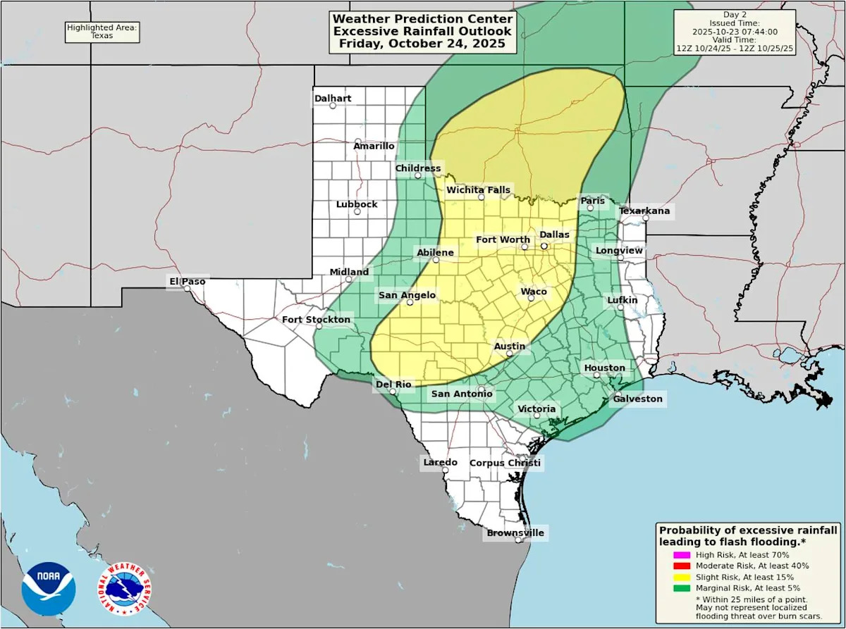
Friday flood risk: Dallas to San Antonio
Heads up: If your Friday travel plans take you to the Dallas-Fort Worth area, Austin or San Antonio, the risk of flooding rainfall arrives late in the day.
TRACK WET WEATHER: Stay informed (and dry) when you use the Houston Chronicle’s interactive live weather radar.
If your travel plans are set for earlier in the day, chances are you’ll get to your destination free of significant delay. A stray downpour remains possible before noon from Dallas to Austin, but heavier rainfall should stay on the Oklahoma side of the Red River through midday.
Storms will increase north and west of Houston by Friday afternoon as daytime heating pushes temperatures into the upper 80s to near 90 degrees.
The flood risk across Texas begins first along the Interstate 35 corridor. Rainfall across a large portion of the state could total 2 to 4 inches. (Weather Prediction Center / Pivotal Weather)
This will raise the risk for localized flooding, especially in urban areas where heavy rainfall can’t soak into the ground as quickly. Worsening drought conditions across Texas have hardened the soil, making it behave more like pavement.
The National Weather Service’s Weather Prediction Center has placed an area from San Antonio along Interstate 35 toward Dallas-Fort Worth and Texarkana under a level 2 out of 4 risk, or at least a 15% chance, of flash flooding Friday. Other parts of the state, including Southeast Texas, will be under a level 1 out of 4 risk, or at least a 5% chance, of excessive rainfall, primarily late Friday.
Houston’s highest flood risk on Saturday
Saturday’s rainy forecast comes in two rounds: The first round arrives before noon and the second pushes in likely by sunset. While it won’t rain solidly from morning to night, a 60% to 80% chance of rain means most of us could see some occasionally heavy rainfall.
WINTER OUTLOOK: A developing La Niña pattern could result in a warmer and drier winter across much of Texas. But why?
Minor street flooding will be a possibility across the Houston metro area, especially in any spot that tends to flood during those brief summertime thunderstorms. Will Saturday’s showers be particularly long-lasting or life-threatening? Probably not, but you certainly don’t want to drive through any flooded roadway you may encounter Saturday.
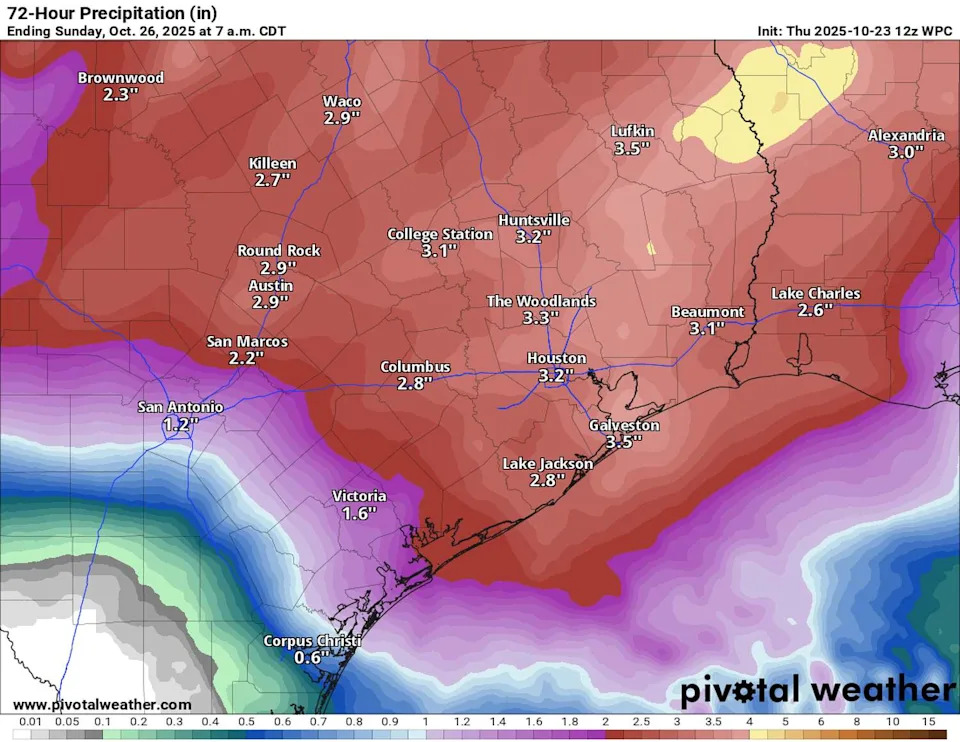
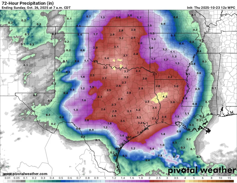
Rainfall totals across much of Southeast Texas are expected to reach 2 inches or more. Heavy rainfall and the risk of flooding arrives mainly late Friday into early Saturday and once more Saturday evening. (Weather Prediction Center / Pivotal Weather)
The second round of storms Saturday night could also bring a few gusty storms to the Houston area. A few severe thunderstorms can’t be completely ruled out as Southeast Texas enters its second severe weather season of 2025.
Heavy rainfall and storms should taper through Saturday night, leaving mainly light lingering showers early Sunday south of Interstate 10.
Turning cooler by Halloween
For anyone itching for cooler weather, the long-range outlook provides a glimmer of hope.
Another cold front is expected to sweep across Southeast Texas early next week. By next Wednesday, some forecast models suggest temperatures could drop into the lower 70s by Halloween, a change that would take temperatures into below-normal territory, a change from last year’s weirdly warm Halloween.
Is this cold front the one that finally brings summer to a close? It’s too soon to know for sure, but it certainly looks promising.
This article originally published at North and Central Texas under flooding threat Friday. Here’s when Houston is at risk..