

While we saw severe weather across parts of the state on Saturday, the bulk of the action happened in North Texas but don’t let your guard down yet. That system will influence our weather in Central Texas throughout much of next week, bringing daily chances for rain and thunderstorms.
By next Friday morning, the Austin metro area’s rainfall totals could reach 2 to 3 inches with isolated amounts of up to 4 inches in areas. That would be the most rain we’ve had in a storm event lasting multiple days since early July.
Saturday’s cold front has stalled across South Texas, and the next weather feature to watch is a closed system of low atmospheric pressure lingering near the Baja California coast. That system will send several atmospheric disturbances into Texas that will keep rain chances high across the region.
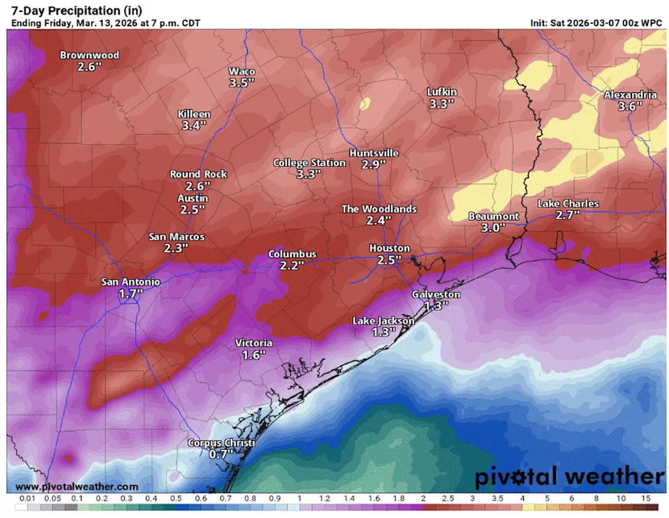
Rain and thunderstorm chances in Central Texas will continue each day through next Thursday, with rainfall totals expected to exceed 2 to 3 inches in some areas. (Pivotal)
Sunday forecast
Overcast skies, spotty showers, light north winds, and cooler temperatures will welcome us Sunday morning. Temperatures will be in the middle and upper 50s through mid-morning and then climb about 10 to 15 degrees by the afternoon. Afternoon temperatures will remain closer to climatological normals for early March, in the upper 60s and low 70s.
While we do expect to see some thunderstorms across the region at times on Sunday, severe weather is not on the menu. Rain chances are about 50% with rainfall totals between a half-inch to an inch.
Monday forecast
A jogger proceeds down the trail near the Wishbone Bridge as a weekend of rain impacts the Austin area, March 7, 2026. (Sara Diggins/Austin American-Statesman)
The comfortable temperatures and north winds will not hang around long once low pressure develops to our north and opens the door to winds from a more southerly direction by Monday. We’ll have a small rain chance, about 30% to 40%, on Monday with a few afternoon thunderstorms possible. Temperatures will be warm, though, with the morning near 60s degrees and the afternoon reaching the low 80s.
Midweek forecast
Rain chances look to ramp up again from Tuesday through Thursday with the potential for some strong and severe thunderstorms.
“For now, it looks like late Tuesday into Wednesday will be favored as a closed low (pressure system) moves across West Texas into Central Texas,” the National Weather Service wrote in a forecast bulletin. “We will likely see some changes in the path of this upper low, but the current latitude looks favorable for a line of convection (storm activity) along a Pacific cold front to accompany the passage of this system.”
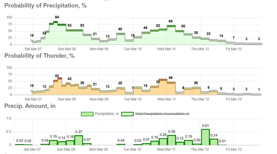
Rain and thunderstorms are likely Sunday in Austin, followed by a brief lull Monday before storm chances ramp up again by midweek. (National Weather Service)
Moderate atmospheric instability and wind shear might allow for a few strong to severe storms, but heavy downpours are the main concern.
“The latest guidance shows a 60 to 90% chance of at least 1 inch of rain for most of our area with a 40 to 60% chance of at least 2 inches for areas north of I-10,” the weather service said. “There is a potential for multiple inches across some areas.”
Once this storm heads east by Thursday afternoon, cooler and drier weather will filter in with temperatures closer to our March normals of 50 degrees and 71 degrees.