
FORECAST HIGHLIGHTS
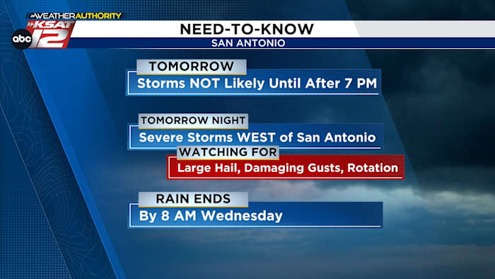
TOMORROW: Most of the day will be quiet, warm, and muggy
TOMORROW NIGHT: Storms are likely
SEVERE RISK HIGHEST WEST OF SAN ANTONIO: Very large hail, 70+ mph gusts, and even isolated tornadoes
WEDNESDAY: Rain clears by 8 a.m.
QUIETER & COOLER: Thursday through the weekend
FORECAST
TUESDAY NIGHT STORMS AND SEVERE RISK
Most of Tuesday will be quiet, muggy, and warm. The greatest chance of storms arrive Tuesday night. A line of storms will spread west to east, arriving in San Antonio after 9 pm. The rain will end in San Antonio by 8 am Wednesday morning.
Tomorrow will be quiet with strong storms possible after 7 pm. (Copyright KSAT-12 2026 – All Rights Reserved)
While there is a low risk for hail and gusty winds in San Antonio, the severe weather risk is much higher west of San Antonio.
Tuesday’s severe risk is highest west of San Antonio and in the Hill Country (Copyright KSAT-12 2026 – All Rights Reserved)
In these areas, marked by a 3 risk out of 5, very large hail, 70+ mph gusts, and even isolated tornadoes will be possible Tuesday evening. Your Weather Authority will continue to monitor any storms that develop, and we will keep you updated!
As for rain, the San Antonio metro area will see about a quarter to half an inch of rainfall. Higher amounts will occur wherever severe storms develop, again mainly west of the Alamo City and in the Hill Country.
CHILLY MORNINGS LATE WEEK
Wednesday morning, skies will quickly clear, and it’ll be warm. Then, a front will sweep through Wednesday night. It’ll bring gusty north winds through mid-morning Thursday. In its wake, it’ll be cooler, with highs near 70 on Thursday. Mid-40s are possible Thursday and Friday mornings.
The latest forecast from Your Weather Authority (Copyright KSAT-12 2026 – All Rights Reserved)Daily Forecast
KSAT meteorologists keep you on top of the ever-changing South Texas weather.
QUICK WEATHER LINKS
Copyright 2026 by KSAT – All rights reserved.