
Central Texas finally saw much-needed rain over the weekend, but rainfall totals ended up lower than what forecast models suggested last week. Most locations picked up only between a quarter-inch and a half-inch of rain.
So far this month, Austin’s main weather observation site at Camp Mabry has recorded 0.7 inch of rain, but the year overall has been dry. Since Jan. 1, we’ve recorded just over 2.5 inches of rainfall, which is about 2.75 inches below normal at this point in the year.
While the weekend rain wasn’t exactly a drought-buster, we can still keep our hopes high — or, in the words of a classic infomercial: “But wait … there’s more!”

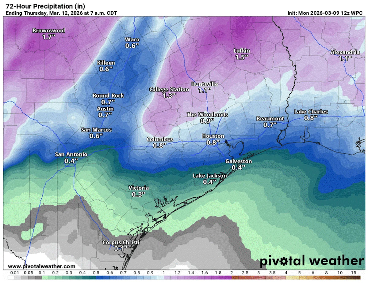
Rainfall totals from now until Thursday morning will range from a half-inch to more than an inch, especially in the Hill Country. (Pivotal)
Tuesday’s weather
After a foggy and drizzly start to the week, another round of heavy rainfall and strong thunderstorms is forecast for Tuesday and Wednesday as a potent system of low atmospheric pressure and a cold front move through the region.
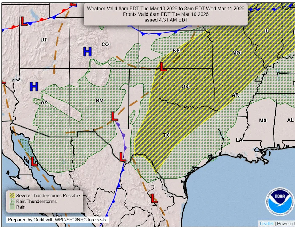
A storm system and cold front will move into the Lone Star State on Tuesday and Wednesday with potentially severe weather and heavy rainfall. (Weather Prediction Center)
Morning: We’ll wake early Tuesday under dark and cloudy skies, as the sun doesn’t rise in Austin until 7:46 a.m. because of daylight saving time. Temperatures will be near 70 degrees, but don’t expect the same foggy start we saw Monday. Winds will be a bit gusty out of the south, which will help keep the low-level moisture mixed and prevent it from settling in and creating a layer of fog.
Midday: Sprinkles or light showers are possible through midday, but the heavier rainfall will hold off during the morning. The upper-level low pressure system approaching from the west will help produce active weather across West Texas during the first half of Tuesday.
CLOUD FORMATIONS: Identifying these clouds will help you prepare for the Texas severe weather
Afternoon: However, across Central Texas an atmospheric lid, known as a capping inversion, will remain in place until surface temperatures warm up enough for rising air to break through the “cap.” Once that happens, the atmosphere will gradually destabilize through the afternoon and evening, allowing rain and thunderstorms to develop.
Breezy south winds will continue throughout the day, with gusts up to 25 mph. Afternoon temperatures are expected to climb into the upper 70s and lower 80s.
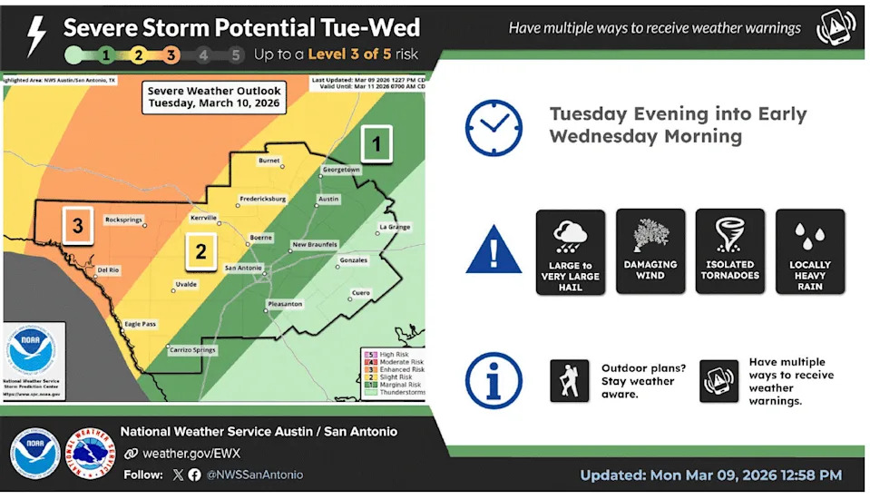
A couple of severe storms are possible late Tuesday and into Wednesday as a cold front moves through the region. The main threats will be large hail, damaging winds and we can’t rule out an isolated tornado. (National Weather Service)
Night: By the evening, the upper-atmospheric low pressure will begin to push east and move into Central Texas. This will enhance our thunderstorm potential with some storms producing severe weather, including inch-wide hail and damaging winds exceeding 58 mph.
The National Weather Service’s Storm Prediction Center places Central Texas under a level 1 to 2, out of 5, threat of severe weather on Tuesday and Wednesday morning with the higher threat level west of Austin and the Interstate 35 corridor.
Once the cold front transits east of Austin on Wednesday, drier and cooler weather will settle in for the rest of the work week before 80-degree afternoon temperatures reemerge next weekend.