
The above-normal temperatures and abundant humidity helped fuel the storms, while strong winds at various levels of the atmosphere, known as wind shear, helped organize thunderstorms. The rising air also allows them to grow stronger. Together, these ingredients create an environment capable of producing severe thunderstorms, which can bring large hail, damaging winds and occasionally tornadoes.
We’ll wake up to scattered showers and a few thunderstorms across the region with pockets of moderate to heavy rainfall. The latest forecast models indicate that we may keep the weather active through the first half of the day and we’ll see it gradually taper off through the afternoon.
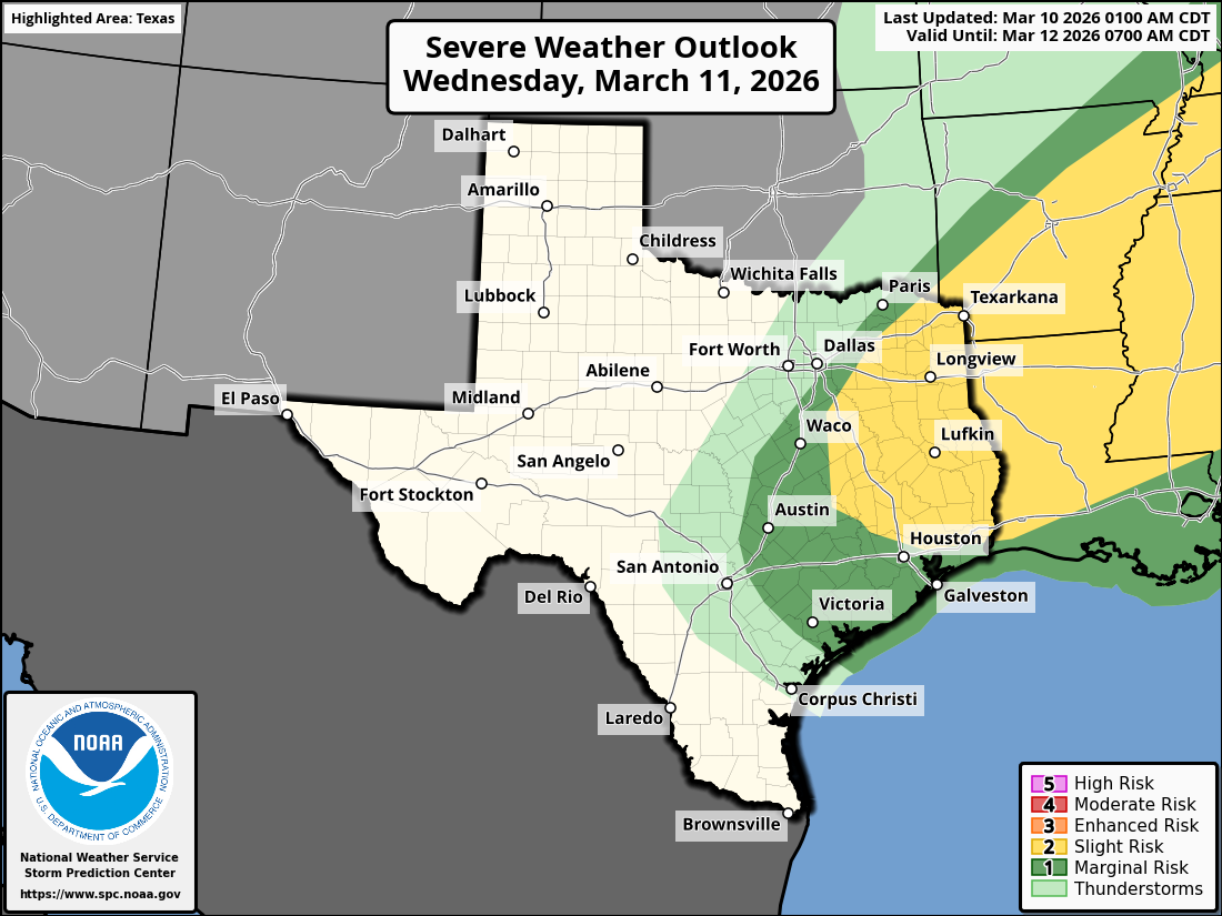
The risk for a couple of strong and borderline severe storms remains on Wednesday, especially along and east of the Interstate 35 corridor. The National Weather Service’s Storm Prediction Center has placed Austin under a level 1 out of 5 risk for severe weather, but East and Northeast Texas is under a level 2 out of 5 risk. Level 1 means isolated but brief severe thunderstorms are possible, while level 2 means severe storms could be more scattered across a wider area.
The track of the upper-level system of low atmospheric pressure “has evolved to pass closer to our forecast area as a deeper system, and that will probably deliver a faster mix-down of westerly winds at the bottom of the low,” meteorologists from the National Weather Service wrote in their daily forecast briefing on Tuesday. “That being the case, we may need to consider cooler afternoon highs for Wednesday afternoon with more areas struggling to get out of the 70s.”
By Thursday, clear skies and dry air will move into Texas as a system of high pressure builds behind the Pacific low pressure and cold front. North winds will blow, with some gusts topping 25 mph. But temperatures will be seasonable, and more typical for early March, with the morning near 50 degrees and the afternoon reaching the upper 60s and lower 70s.
The dry, cool, and refreshing air will be short-lived as winds turn more southerly on Friday, helping temperatures warm into the upper 70s to near 80 degrees, and it will only get warmer from there.
Over the weekend, dew point temperatures will gradually increase, reflecting a rise in humidity. Air temperatures will easily reach the mid-80s on Saturday and climb into the upper 80s to near 90 degrees on Sunday.
It will be a bit warm for South by Southwest weekend, but skies should remain mostly clear for the first half of the weekend before clouds move in on Sunday ahead of the next cold front. That front is currently forecast to move through Sunday afternoon, sending temperatures back to typical March levels by the start of next week.