
Houston turns noticeably cooler Thursday after strong midweek storms push a cold front through Southeast Texas.
This week’s wild temperature swings are a reminder that the winter chill isn’t quite ready to release its grip. How cool will it get and when might even colder weather arrive?
60s return Thursday
Gusty northerly winds will help drag in cool and less humid air to Southeast Texas.
SPRING WINDS EXPLAINED: Did you know Houston’s windiest stretch begins well before the start of hurricane season?
Houston temperatures Thursday will only reach the upper 60s, after a chilly start with morning temperatures starting near 50. On top of Thursday’s slightly below-normal temperatures, it’ll be quite breezy. Wind gusts could reach speeds of 25 to 30 mph, so be sure to keep a firm grip on the steering wheel on exposed roadways, especially while driving on east-to-west overpasses and roadways.
As high atmospheric pressure moves overhead late Thursday, winds should relax.
Friday: Chilly start, warmer afternoon
Our chilly weather begins to change by Friday afternoon, but not before another cold start to the day.
Whether enjoying the final day of spring break or going into the office one final time this week, Friday morning brings temperatures in the mid- and upper 40s. Average temperatures in mid-March range from the lower and mid-50s in the mornings across Southeast Texas, so temps Friday will be about 10 degrees below normal. You’ll definitely want a jacket or coat before heading out the door early Friday.
Sunny skies and the return of southerly winds bring temperatures back into the mid-70s by the afternoon.
WEATHER ALERTS: Spring means severe weather becomes more likely in Southeast Texas. Meet the person responsible for sending alerts.
Each day through the upcoming weekend will get warmer, both in the morning and during the afternoon. Saturday’s morning temps in the mid-50s will become muggy 60-degree weather by Sunday morning, as peak daytime temperatures climb into the 80s ahead of Houston’s next cold front.
Houston’s next cold front this weekend
After Thursday’s brief spring pause, a second cold front reminds us why this season is known for its weather ups and downs.
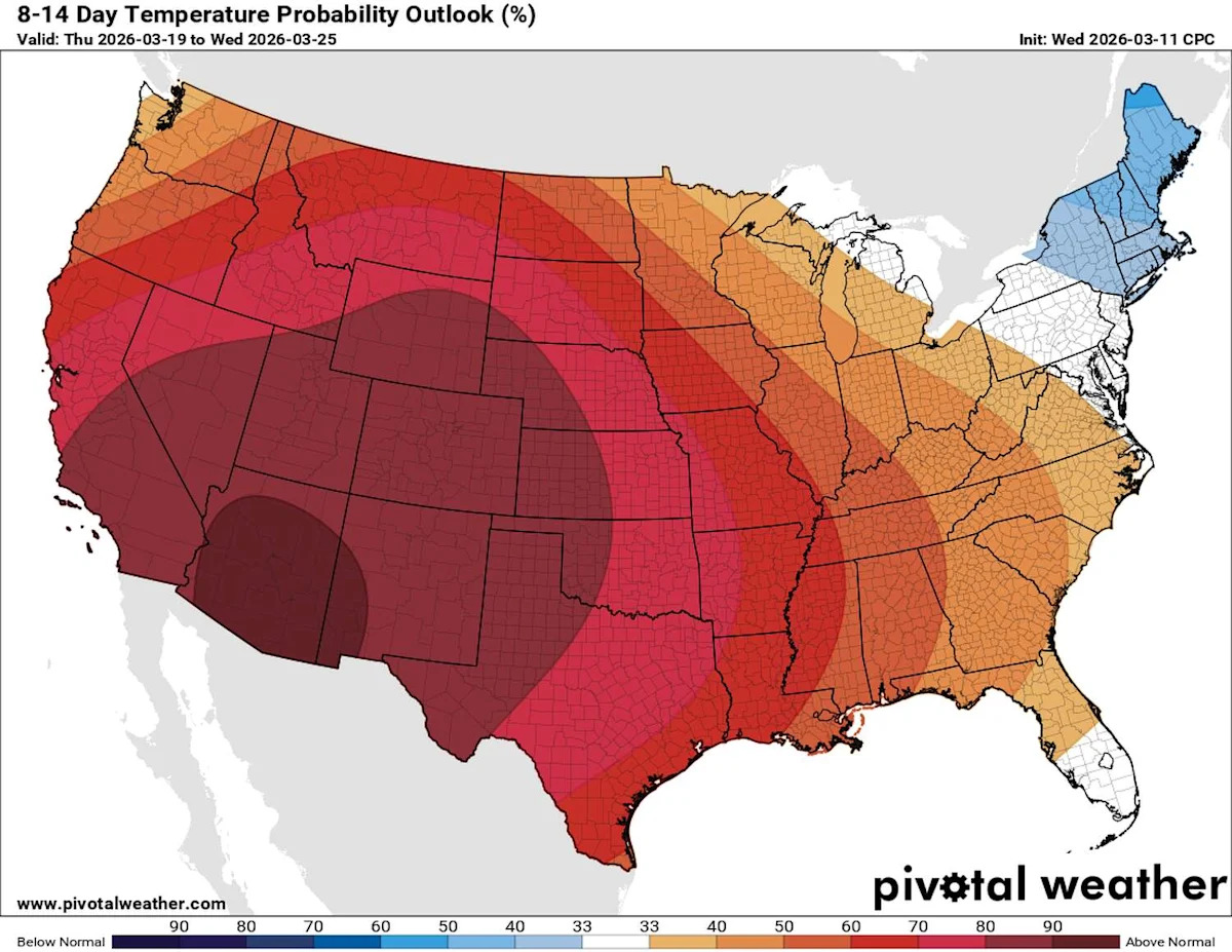
The temperature outlook through March 25 from the National Weather Service’s Climate Prediction Center projects above-normal temperatures (orange and red) across much of the U.S., despite a few cooler days through early next week. (Climate Prediction Center / Pivotal Weather)
A second cold front is poised to drop temperatures from Sunday’s afternoon temps in the mid-80s to Monday’s in the mid-60s. The front is expected to move across Southeast Texas Sunday night into Monday morning. While exact timing on the cold front’s arrival could move over the next day or two, the overall changes to Houston’s weather won’t differ.
Early next week will feature temperatures several degrees below normal, and significantly colder than what we’ve gotten used to in recent weeks.
This article originally published at After Wednesday’s storms, Houston cools into the 60s – but how long will it last?.