

AUSTIN, Texas — Severe thunderstorms were forecasted multiple days out for Wednesday morning thunderstorms and Mother Nature delivered.
To our west, one supercell produced hailstones the size of grapefruits, around 4 and a half inches wide. Hail this large will do significant damage and can weigh up to a pound! As the line approached, it was expected for the line to weaken and be primarily sub-severe, which ended up being accurate. Only one thunderstorm gust in Llano was technically “severe” with a wind gust of 64 miles per hour.
With severe weather out of the realm of possibilities, rainfall became our main event. So let’s get your rainfall report card.
Severe thunderstorms were forecasted multiple days out for Wednesday morning thunderstorms and Mother Nature delivered. (CBS Austin)
ALSO | Lightning strike sparks brush fire in Georgetown
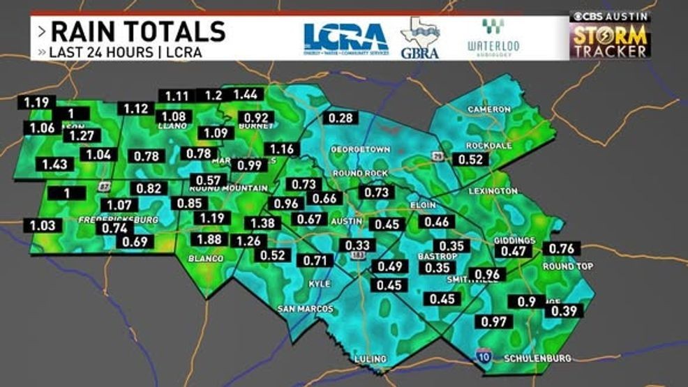
In the past 24 hours, there have been dozens of rainfall gauges across the area that reached one inch of rainfall with streams already responding nicely. This is a step in the right direction for our area, but we will still need more. The Hill Country gets an A+, but the I-35 corridor underperformed.
We failed to reach the 1-inch mark in Austin as rainfall rates slacked, and the line fell apart. We did get close, as Austin Camp Mabry picked up around 0.70″ and Austin-Bergstrom Airport got around 0.40″. This extends the 7th longest running streak of days below one inch to 136 straight days. Austin gets a B- for rainfall.
East of Austin, rainfall rates picked back up, and a few spots got close to that one-inch mark, but most were around a half inch. The line re-intensified early this morning and will continue further east towards Houston. East I-35 corridor gets an A.
An overall healthy dose of rainfall. No flash flooding, no significant severe weather, just good ole fashioned rain and thunderstorms.
Overall: A-
This rainy pattern was great for our entire area. In the past five days, Austin picked up 1.4” with dozens of other areas picking up well over an inch and a few even near or more than two inches! That’s great news and a great start to what looks to be a much drier March ahead of us.
Elsewhere in the country, Tuesday was a very active day. There were 510 reports of severe weather yesterday, with 21 reported tornadoes – four reported in Texas.
Among the strongest storms were in Illinois, where a hailstone the size of a DVD (six inches) was reported in Kankakee. If confirmed, this would be the largest hailstone ever recorded in the state of Illinois, surpassing the previous record of 4.75 inches set in Minooka on June 10, 2015.
An EF-1 tornado touched down near Moro and Midway, causing damage along a 1.6-mile path. Tornado Emergencies were issued for a very powerful supercell in Indiana where two are confirmed dead after a tornado wiped three houses off their foundations. The exact strength of this tornado is not quite known as of Wednesday early afternoon, but a damage assessment will likely reveal EF2+.
For the latest on the forecast, head over to cbsaustin.com/weather.