
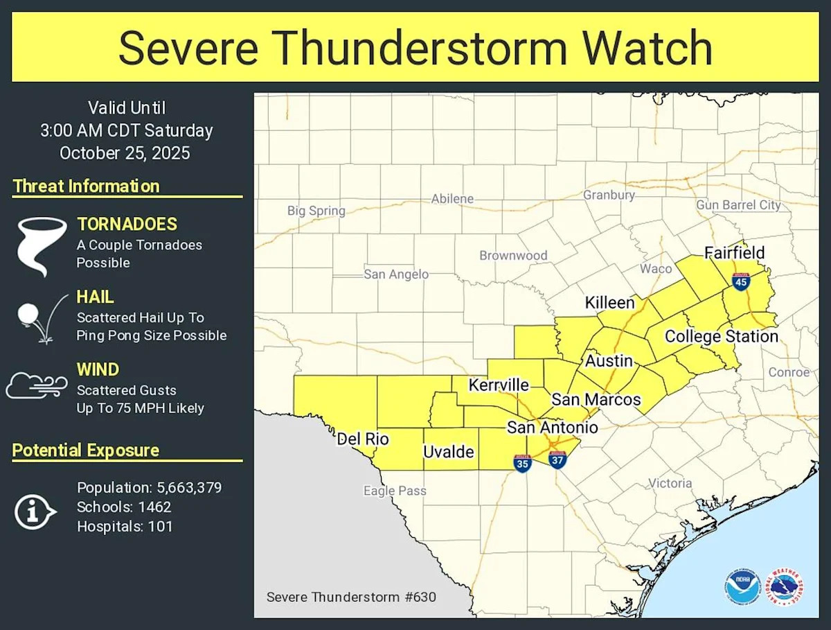
8:25 p.m. Update: A severe thunderstorm watch has been issued for much of South-Central Texas, including the southern Edwards Plateau, Hill Country, and I-35 corridor, the National Weather Service announced Friday night. The watch is in effect from 8 p.m. Friday through 3 a.m. Saturday morning.
The San Antonio and Austin metro areas are included in the severe thunderstorm watch. Other cities within the watch area include New Braunfels, San Marcos. Kerrville, Fredericksburg, Boerne, Hondo, Uvalde, Burnet, Marble Falls and Blanco.
As of 8:25 p.m. radar, a line of strong to severe thunderstorms is located 100 to 150 miles northwest of San Antonio. This line is expected to move through the Hill Country over the next several hours, arriving to the San Antonio area by around midnight. There is a high chance of storms within the metro area between midnight and 6 a.m. Saturday.
The primary risks for tonight’s thunderstorms will be large hail and damaging wind gusts. There is also a risk of an isolated tornado, but the overall tornado threat will remain low.
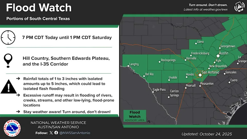
The highlighted area in green is under a flood watch from 7 p.m. Friday through 1 p.m. Saturday (nws austin/san antonio)
2 p.m. Update: A flood watch in effect from 7 p.m. Friday to 1 p.m. Saturday has been issued by the National Weather Service for much of South-Central Texas.
Areas included in the flood watch include the Texas Hill Country, southern Edwards Plateau, and the Interstate 35 corridor, including the entire San Antonio metro area. Other cities included in the watch include Austin, New Braunfels, San Marcos. Kerrville, Fredericksburg, Boerne, Hondo, Uvalde, Burnet, Marble Falls and Blanco.
TIMELINE: Severe storm, hail risk is increasing tonight across South Texas.
A line of strong to severe thunderstorms is expected to move into the northern Hill Country, mostly after 8 p.m. Friday. The line will continue to plunge southeast, making its way into the I-35 corridor mainly after midnight. San Antonio’s best chance of heavy rainfall will occur overnight between 1 a.m. and 7 a.m. Saturday.

Shown is the potential future weather radar at 3 a.m. Saturday, as a line of strong storms moves through South-Central Texas. (Pivotal Weather)
Between an inch and 3 inches of rain is expected across the flood watch area, with isolated amounts of up to 5 inches possible, according to the National Weather Service. However, it’s difficult to pinpoint exactly where the most rainfall will occur.
“Excessive runoff may result in life-threatening flooding of rivers, creeks, streams and other low-lying and flood-prone locations in the Hill Country and southern Edwards Plateau as well as urban areas along the I-35 corridor,” the weather service said.
Along with potential flooding, we could see large hail and damaging wind gusts as the initial push of storms moves into the region. All of South-Central Texas is under a level 2 of 5 risk of severe thunderstorms. A level 2 risk, according to the weather service’s Storm Prediction Center, means the possibility of scattered but brief severe thunderstorms capable of producing not just hail and damaging winds but also an isolated tornado.
This article originally published at Severe storm watch issued for San Antonio, Texas Hill Country. Large hail possible..