
On Friday we mark the spring equinox, traditionally known as the first day of spring. However, the start of spring in Austin will feel more like the start of summer, as we kick off a string of days featuring 90-degree weather in Austin that could match or break daily heat records, some dating back more than 50 years, according to the National Weather Service.
Rain continues to be elusive in the daily forecast and, with low humidity levels this week, we’ll have an elevated threat of fast-spreading wildfires this weekend.
Expect another sunny day in Austin on Friday, with balmy south-southwest winds of 5 to 10 mph helping push afternoon temperatures into the lower 90s. If the forecast high of 91 holds up, that would be about 15 degrees warmer than normal and would match the daily record for March 20 set exactly 50 years ago in 1976.

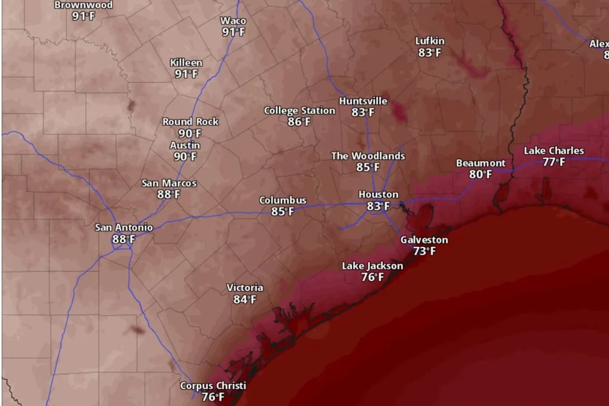
Austin temperatures could reach 90 degrees by 4 p.m. Friday, according to the National Blend of Models, a composite weather forecast model. (National Blend of Models/Pivotal Weather)
Although we’ll have clear skies Friday night, the persistent southerly winds will help keep overnight temperatures above 60 degrees before dawn Saturday.
Heat dome and high fire threat
Heralding the start of an especially warm spring season in Austin is the arrival of a system of high atmospheric pressure that will produce a heat dome over Texas. The high pressure causes air to sink toward the ground, where the compression of air causes temperatures to increase. A resulting “dome” of heat and pressure ends up trapping the water vapor-laden warm air like a pot lid, and denying any chances for rain clouds to form in the upper atmosphere.
“Subsidence underneath the ridge (of high pressure) and below-seasonal average moisture levels keep rain out of the forecast,” the weather service said in a forecast discussion posted online Thursday.
Especially dry air, combined with the lack of rainfall and parched vegetation, will sustain a threat for fast-spreading wildfires. The Texas A&M Forest Service has placed most of the state under a moderate fire danger on Friday. However, on Saturday, the forest service has placed areas along and east of the Interstate 35 corridor, including the Austin metro area and the Hill Country, under a high level of fire danger.
“On most days, winds will be light at 10 mph or less with only elevated fire weather conditions possible,” the weather service said. “Wind speeds increase to 10 to 15 mph with gusts to 20 to 25 mph across many areas on Sunday and with the lowest minimum humidities on that day, near-critical fire weather conditions are possible.”
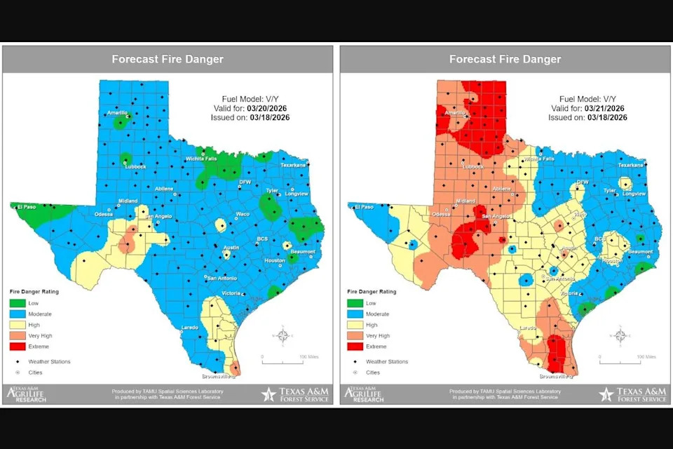
The Texas A&M Forest Service has placed much of the state under a moderate fire danger on Friday, but areas along and east of the Interstate 35 corridor, including the Austin metro area and the Hill Country, will be under a high risk of fire danger Saturday. (Texas A&M Forest Service)
Weekend and beyond
“The mid-level ridge (of high pressure) continues to build over Texas this weekend,” the weather service said, adding that record heat would be likely over the weekend.
Austin on Saturday should be sunny and breezy with daytime temperatures reaching 95 degrees, which would be about 20 degrees warmer than normal for March 21. A reading like that also would obliterate the 74-year-old record of 91 degrees set in 1952. Saturday night temperatures, also getting a bump from warm southerly winds of 5 mph, will stay above 63 degrees, which would be about 10 degrees warmer than normal.
We’ll get another day of sunshine and blues skies Sunday, with blustery winds of 5 to 10 mph, including gusts as strong as 20 mph. Daytime temperatures could soar to 94 degrees, while overnight temps will bottom out around 61 degrees before dawn Monday. If the forecast high of 94 holds up, that would be nearly 20 degrees hotter than normal and just 2 degrees shy of the March 22 daily heat record set in 1971.
A weak cold front arriving early next week could take the edge off the potentially record-setting heat, forecasters said.
“The mid-level ridge weakens and retreats to the west, allowing a brief cold frontal incursion early next week,” the weather service said. “As a result, high temperatures back off from record levels, though remain well above average.”
Monday and Tuesday will be sunny, with afternoon temperatures peaking at 89 or 90 degrees, as north northeast winds blow at around 5 mph. Overnight temperatures on both nights stay mostly in the 60s.
“High temperatures warm again midweek ahead of a late-week cold front,” the weather service said, adding that “the late-week cold front likely brings below-average temperatures and possibly a few showers.