
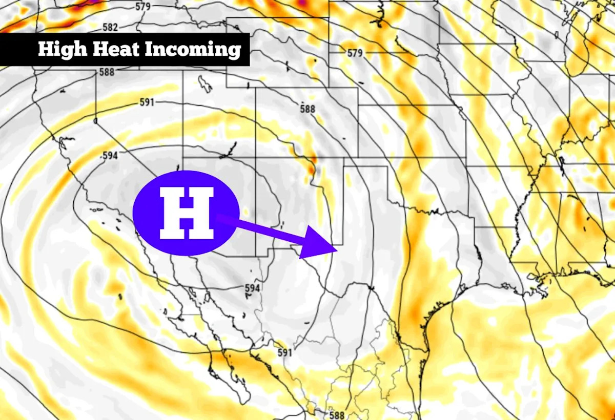
A strong high pressure system has been baking the desert Southwest this week. On Thursday, temperatures in Phoenix rose to 105 degrees, smashing the Arizona city’s daily temperature record for March 19 by nearly 10 degrees. The Las Vegas area also broke records, as temps rose into the upper 90s across southern Nevada.
That same system of high atmospheric pressure will shift eastward over the next couple of days, bringing summer-like heat to much of Texas. Thankfully, the high pressure is expected to weaken slightly as it moves east, so it won’t be quite as hot across the Lone Star State. How long will the heat last, though? Here’s what to expect.
Friday’s forecast
A cool, pleasant start is expected Friday morning across South Texas. San Antonio temps will sit in the mid-50s by 7 a.m. to 8 a.m., rising into the 60s by 9 a.m. Skies will be bright and sunny throughout the day, allowing temps to rise rather quickly.
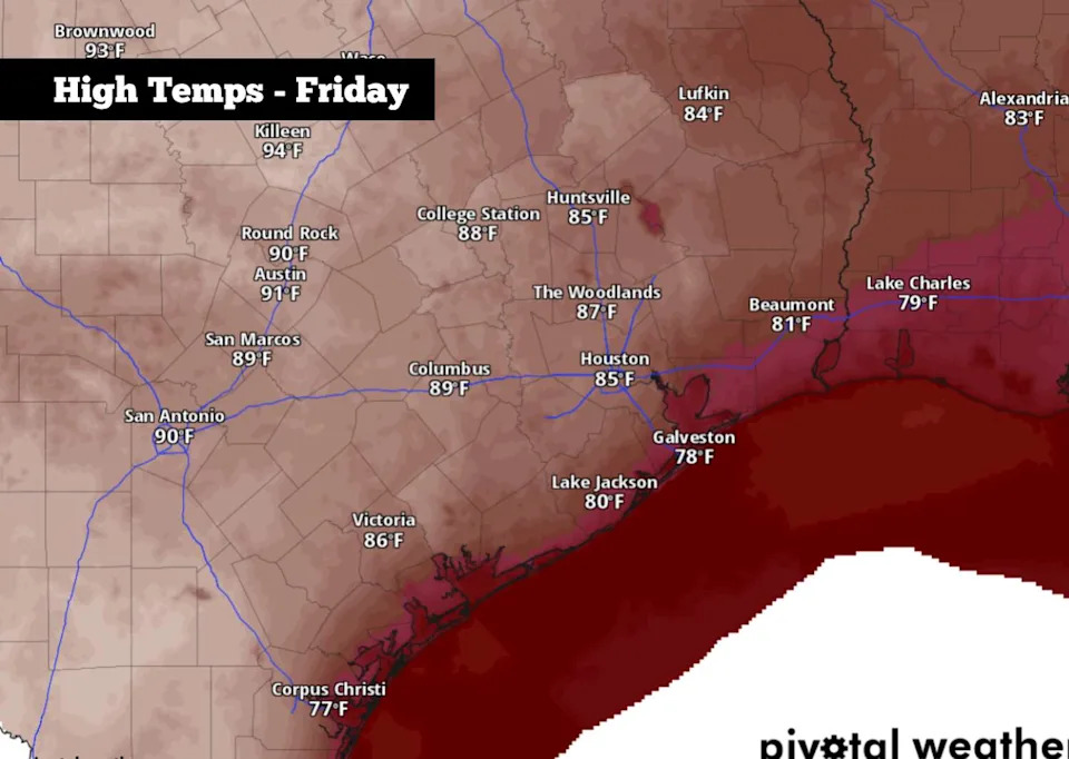
Afternoon temperatures on Friday could reach 90 degrees in San Antonio and the upper 80s across Texas. (Pivotal Weather)
By noon, San Antonio will see temperatures nearing the 80-degree mark, and they’ll continue rising into the upper 80s to around 90 degrees by the late afternoon. Peak temps will likely come a few degrees shy of the daily record of 93 degrees, set back in 1976.
Friday evening, temperatures will be slow to cool off. San Antonio will sit in the 80s through the early evening, only falling into the 70s after 8 p.m. By the overnight hours, temps will fall into the upper 50s to lower 60s.
Weekend forecast
As high pressure becomes more centered over Texas, temperatures will continue to inch higher. On Saturday, San Antonio will see afternoon temperatures rise to around 93 degrees, coming very close to the March 21 daily record of 94 degrees. Similar weather also is expected Sunday, as highs reach the lower to mid-90s once again.
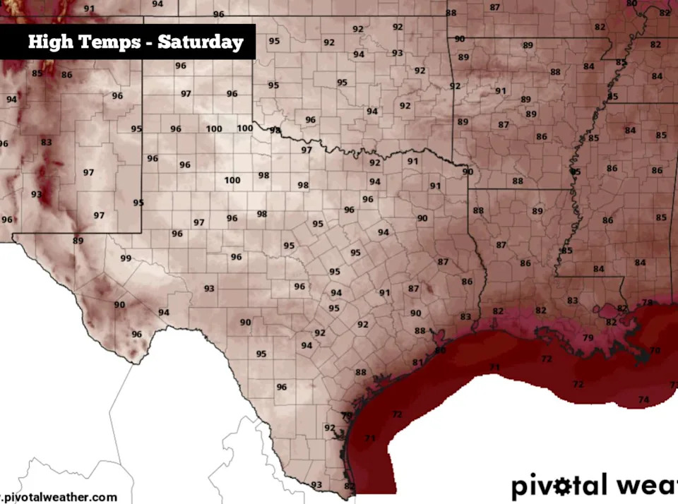
Shown are the expected peak daytime temperatures across Texas on Saturday. Parts of West Texas could hit 100 degrees. (Pivotal Weather)
High pressure also will cause sinking motion in the atmosphere, which will limit cloud formation and keep skies mostly sunny. We won’t have rain chances in South Texas, and drought is likely to expand or intensify across the region.
Any cooler weather coming?
By Sunday evening, a weak cold front is expected to start pushing though parts of North Texas and the Panhandle, bringing cooler temps to those regions by the start of the work week. However, the front is likely to stall well to the north of San Antonio, keeping temps quite warm in the southern part of the state.
Still, San Antonio will likely see temps fall slightly on Monday, as high pressure weakens and the front brings more clouds into the region. Highs will still be more than 10 degrees above average, though, topping out in the upper 80s.
Temperatures will inch higher again through the middle of next week, with afternoons expected to be in the lower 90s from Tuesday through Thursday, under mostly sunny skies. Predawn temps will also be relatively mild, falling to around 60 degrees each night.
Long-range models do show a potential cold front moving into the area by March 27-28, which could bring temperatures a bit closer to the climate-average for a short time. Be sure to stay with expressnews.com/weather for continued daily updates.
This article originally published at High heat is coming to South Texas, but when will temperatures cool back down?.