
LUBBOCK, Texas (KCBD) – Record high temperatures approaching dangerous levels will return to Lubbock and West Texas Wednesday and Thursday. Along with the heat, increasing wind, bringing a significant grassland fire threat that may impact your outdoor plans and activities.
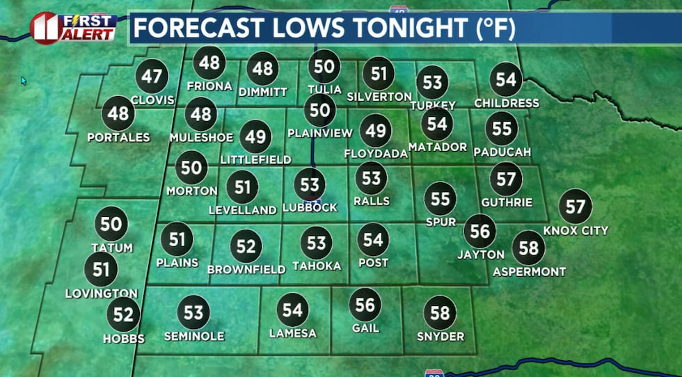 A cool but not as chilly start to the day.(KCBD First Alert)
The Heat
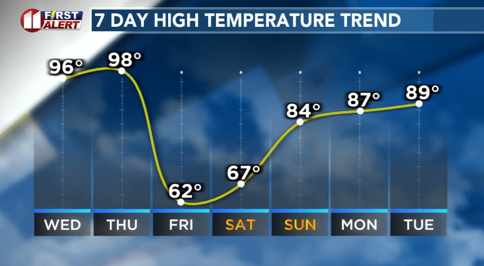
Over the next two days, Wednesday and Thursday, temperatures will climb to well above average for late March. Similar to the past weekend, it will feel more like Summer.
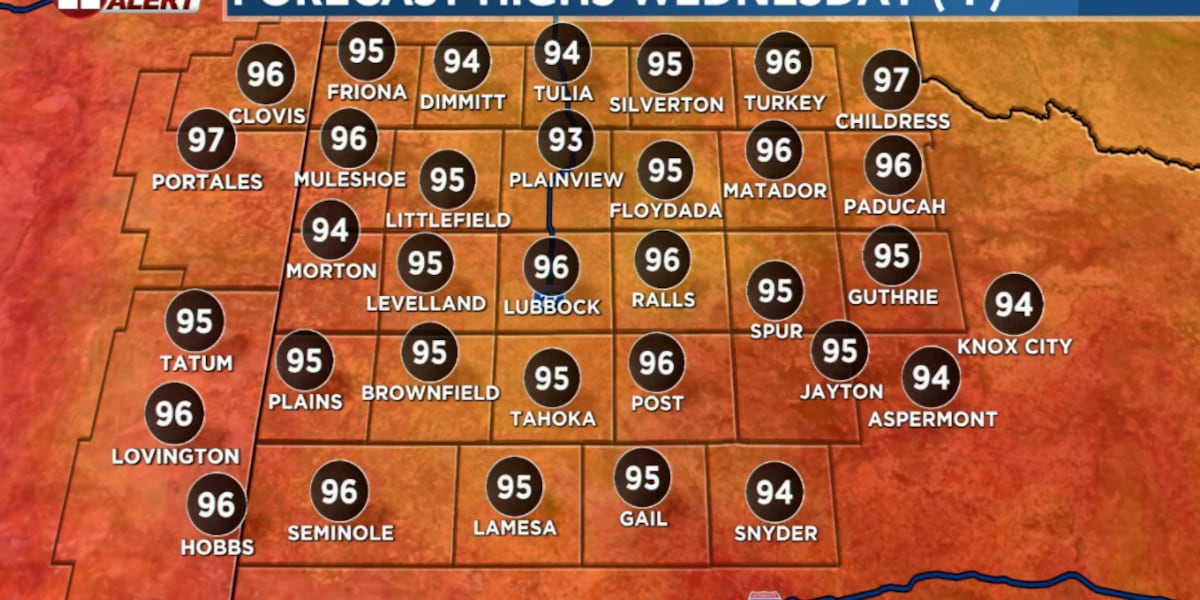
Lubbock-area temperatures Wednesday will peak in the mid-90s then Thursday – the real scorcher — in the upper 90s to near 100 degrees. This kind of heat in late March is very unusual and is likely to break records.
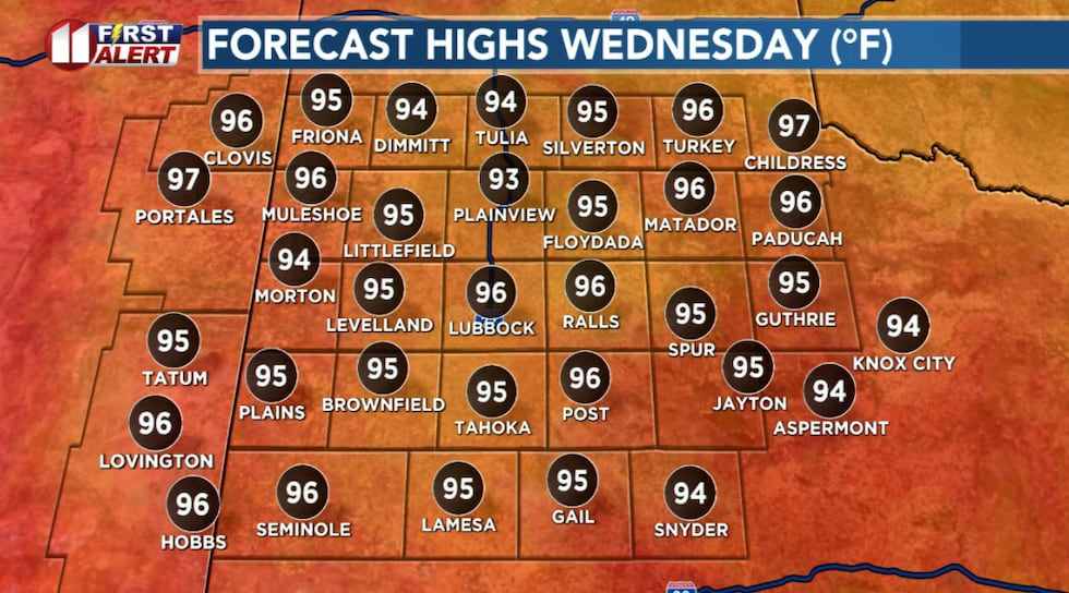 Record heat expected Wednesday afternoon. Lubbock’s March 25 record high is 91° (set just last year).(KCBD First Alert)
The culprit, if you will, is the same as the weekend. A extremely strong area of high pressure, settling directly over West Texas. Basically, a giant heat dome.
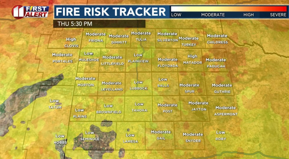
The Fire Danger
The combination of extreme heat, low humidity, wind, and dry fuels, will create critical fire conditions Wednesday and Thursday. Even through Friday will be MUCH cooler, it will be the windiest day, keeping the fire danger elevated. All three days are NO BURN DAYS.
 Record heat Wednesday and Thursday, then a major cooldown Friday.(KCBD First Alert)
The National Weather Service already has issued a Fire Weather Watch for the region from Thursday morning into Thursday evening.
Now is not the time for any outdoor burning or activities which might involve an open flame or generate sparks or even extreme heat. In the forecast conditions even small sparks can ignite a fire that spreads rapidly and is difficult to bring under control.
 The wildfire, or grassland fire, danger will increase as winds increase the next few days.(KCBD First Alert)
Burn bans are in effect for many West Texas counties and, as a reminder, any day a Red Flag Warning (aka a Fire Weather Warning) is in effect for Lubbock County there is an automatic burn ban in effect.
The Wind
Winds will increase Wednesday to around 15 to 25 mph with gusts around from 25 to 35 mph. Thursday the wind is anticipated to increase to around 20 to 30 mph with gusts from 30 to 40 mph possible.
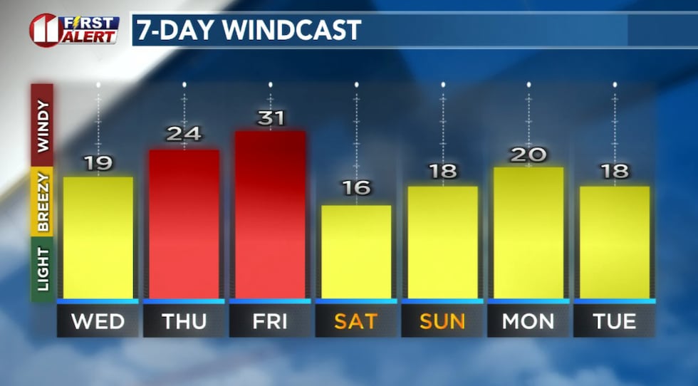 Forecast peak sustained winds are shown in this graph. Peak gusts will exceed the values shown here.(KCBD First Alert)
A cold front is expected to push through early Friday morning, bringing the strongest wind of the week. These winds, combined with the dry conditions, will maintain the elevated fire danger despite much cooler temperatures.
The wind Friday may be strong enough to make outdoor activities… challenging.
Weekend Relief
The good news is, for many people, the cold front Friday morning will bring a significant cooldown. We anticipate high temperatures will be 30 to 35 degrees lower than Thursday’s.
Breezy conditions are likely to linger into early Friday evening before gradually calming down.
We’ll see more typical late-March weather Saturday, though breezy (but not as windy as Friday!) conditions could develop during the afternoon.
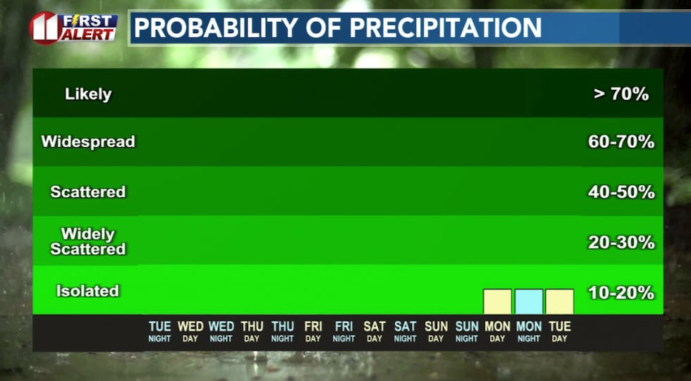
Slim Rain Chance
A slight chance of rain currently is in our forecast for late Monday into Wednesday. This is based on the anticipated approach of the next weather system. Small changes between now and then may raise or lower, or even erase, this chance.
 There is a slight chance a weather system may bring rain to the area next week.(KCBD First Alert)
Stay weather aware over the next few days, and make sure to stay hydrated if you’re spending time outdoors. Keep an eye on our forecast for potential updates.
On This Date
On this date in 1962, a severe dust storm dropped visibility to near zero over much of West Texas thanks to intense westerly wind gusts between 60 and 85 mph. The KLVT radio station in Levelland recorded the highest gust in the state during this event at 85 mph. Damage was confined mostly to signs, roofs, utility lines, and fences, however cotton trailers were overturned and damaged at Seminole. This was one of the worst dust storms in the area since 1955, with dust swept deep into South Texas.
(Source: National Weather Service, Lubbock)
Copyright 2026 KCBD. All rights reserved.