
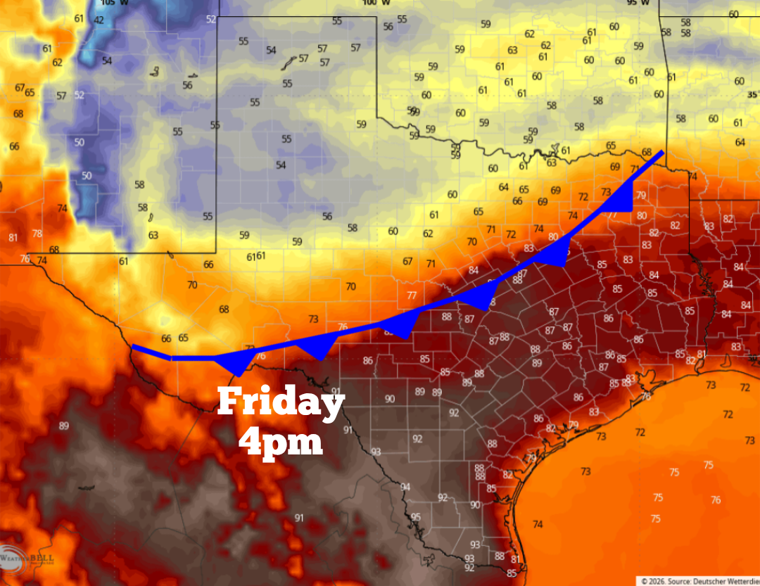
Shown are the expected temperatures across Texas at 4 p.m. Friday as a cold front bisects the state.
WeatherBell
There’s no sugarcoating it — March has been way hotter than it should be. Several Texas cities, including Dallas, Austin, Lubbock and Amarillo, are on track to record their warmest March in weather history. Mercifully, some temporary relief on the way, as a cold front is set to push through Texas throughout the day on Friday.
The front will be very strong across parts of West Texas and the Panhandle, bringing up to a 40-degree drop in afternoon temperatures between Thursday and Friday. Granted, the front will weaken as it progresses south, but it might still bring a noticeable drop in temperatures as far south as San Antonio. Here’s what you can expect.
Article continues below this ad
Thursday’s forecast
Before the front arrives, Thursday will be another very warm day across Texas, with temperatures in some locations likely to reach record-setting levels.
The Panhandle will be one of the hottest places in the state. Amarillo will top out near 99 degrees, completely shattering the March 26 record high temperature of only 88 degrees. Record highs are also expected to be set from Lubbock to Midland-Odessa.
Shown are the expected high temps across Texas on Thursday. Highs could reach near 100 degrees from the Panhandle to the Trans Pecos area of far West Texas.
Pivotal Weather
The weather won’t be quite as hot as you push eastward. In San Antonio, morning temps will sit in the mid-60s, under mostly cloudy skies. But by the afternoon, bright sunshine will return, resulting in temps rising back to near 90 degrees. Winds will be breezy, with frequent wind gusts of more than 20 mph expected.
Article continues below this ad
Similar weather is expected up the Interstate 35 corridor, from New Braunfels and Austin all the way up to the Dallas-Fort Worth metroplex. Highs will generally be 12 to 16 degrees above-average for late March.
Cold front Friday
The incoming cold front will surge through the Panhandle, along with West Texas early Friday. Then by the early afternoon, the front will likely already be through the Dallas-Fort Worth area and starting to move into the northern Texas Hill Country.
Article continues below this ad
Wind gusts could reach 40-50 mph across West Texas as the cold front moves through the region on Friday.
Pivotal Weather
A dramatic drop in temperatures is expected across West Texas. Amarillo, for instance, is likely to top out in the mid- to upper 50s on Friday, which would be more than 40 degrees colder than Thursday afternoon’s highs. Winds are also expected to be strong, with some gusts between 40 and 50 mph throughout the western half of the state.
The front will weaken and start moving slower as it approaches the San Antonio area. Still, it’ll likely arrive in the metro area by around 9 p.m. Friday night, as a northerly wind shift will bring cooler air into the region.
Cooler Saturday temps
This front won’t make the weather “cold” as much as “less hot” across South Texas. However, it will keep temperatures a bit closer to average for late March. Saturday morning temps are likely to drop into the upper 50s before warming into the upper 70s to lower 80s by Saturday afternoon. Overall, highs will be about 10 degrees cooler than Friday.
Article continues below this ad
A more significant drop in temps is expected across North Texas, where highs on Saturday will top out in the upper 60s to lower 70s. While the front will bring an increase in clouds, it’s not expected to bring significant rain chances.
The cooler weather will be short-lived. San Antonio will likely see afternoon temps in the mid-80s by Sunday, then rising back into the upper 80s to lower 90s during the first half of next week.