
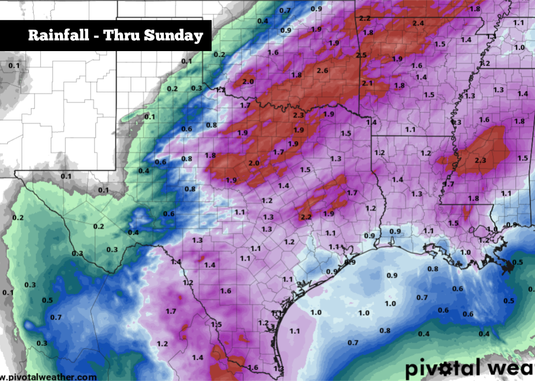
Shown are the potential cumulative rainfall totals across Texas through Sunday night.
Pivotal Weather
An active weather pattern is setting up across Texas, as a cold front pushing south through the region will interact with ample Gulf moisture moving north. The system is likely to bring high rain chances across the state over Easter weekend, as well as gusty winds and below-average temperatures.
If you’re planning on travelling for the holiday, heavy rain at times could force slower travel and longer commute times, especially on Saturday. Parts of the state also could still be rainy on Easter Sunday, as egg hunts get underway. Here’s a day-by-day timeline of what you can expect.
Article continues below this ad
Friday — the best day to travel
Much of the state will stay dry on Friday, at least for the majority of the day. Partly to mostly cloudy skies are expected from San Antonio to Dallas to Houston, and temps are expected to reach the 80s almost statewide. From the afternoon into the early evening, this will be the best time to travel, before rain chances increase.
Shown are the expected high temperatures on Friday in Texas, before the cold front arrives.
Pivotal Weather
Storm chances will start rising Friday evening, especially across North Texas, where storms are expected to become widespread after 6 or 7 p.m. Rain chances will be lower farther south, with about a 30% chance of rain expected from Austin to San Antonio after 10 p.m. Friday.
Article continues below this ad
Saturday: Cold front brings heavy rain
A strong cold font will start to push through North Texas early Saturday, and it will make its way into South Texas by the afternoon. As it progresses through the state, it’s likely to bring a line of showers and thunderstorms, some of which could be heavy.
The highest rain chances from the morning through midday will be in North Texas, with storms transitioning into Central and South Texas by the afternoon and evening.
Article continues below this ad
Shown is the likely position of the cold front at 2 p.m. Saturday, according to the 3kNAM weather model.
WeatherBell
For San Antonio specifically, the cold front will push into the metro area around 3 or 4 p.m. Saturday, resulting in widely scattered showers and storms throughout the region. Temperatures will also drop suddenly. After highs reach near 80 degrees, temps will be near 60 degrees by 7 p.m.
Sunday: Rain continues for some
Moisture will continue to move south on Easter Sunday. The highest chance of rain will be in deep South Texas, from Laredo eastward to the Rio Grande Valley and Corpus Christi. There, flash flooding will also be possible.
Article continues below this ad
In San Antonio, we’ll have a 40-50% chance of rain Sunday morning, especially before 9 a.m. By the middle of the day, rain chances will start to decrease, but chances of isolated showers will remain into the afternoon and evening.
Some good news: While rainfall is likely to affect Easter travel and force some of us inside, the threat of severe thunderstorms will be relatively low. However, some of the strongest activity, especially Saturday afternoon as the cold front arrives, could still produce small hail and gusty winds. Widespread severe weather is not expected to occur, though.
Temperatures are expected to be below average across much of the state on Easter Sunday. In San Antonio, expect morning temps in the mid-50s, and afternoon temps rising into only the mid- to upper 60s. Winds will be sustained around 15 mph through much of the day, with some gusts as strong as 25 mph expected.
Article continues below this ad
Temperatures will actually be slightly warmer as you move north across Texas because of more sunshine. The Dallas-Fort Worth area will rise to around 70 degrees, while parts of the Texas Panhandle will push into the mid-70s.