
LUBBOCK, TX (KLBK) – KLBK Chief Meteorologist Jacob Riley has an update on our Friday evening severe weather risk for April 3, 2026.
Another round of strong to severe storms are expected to develop across portions of the KLBK viewing area late Friday evening, lasting into the early morning hours of Saturday. While not everyone will see severe storms, let alone rainfall, some could see damaging wind gusts, large hail, and possibly even an isolated tornado or two.
TONIGHT
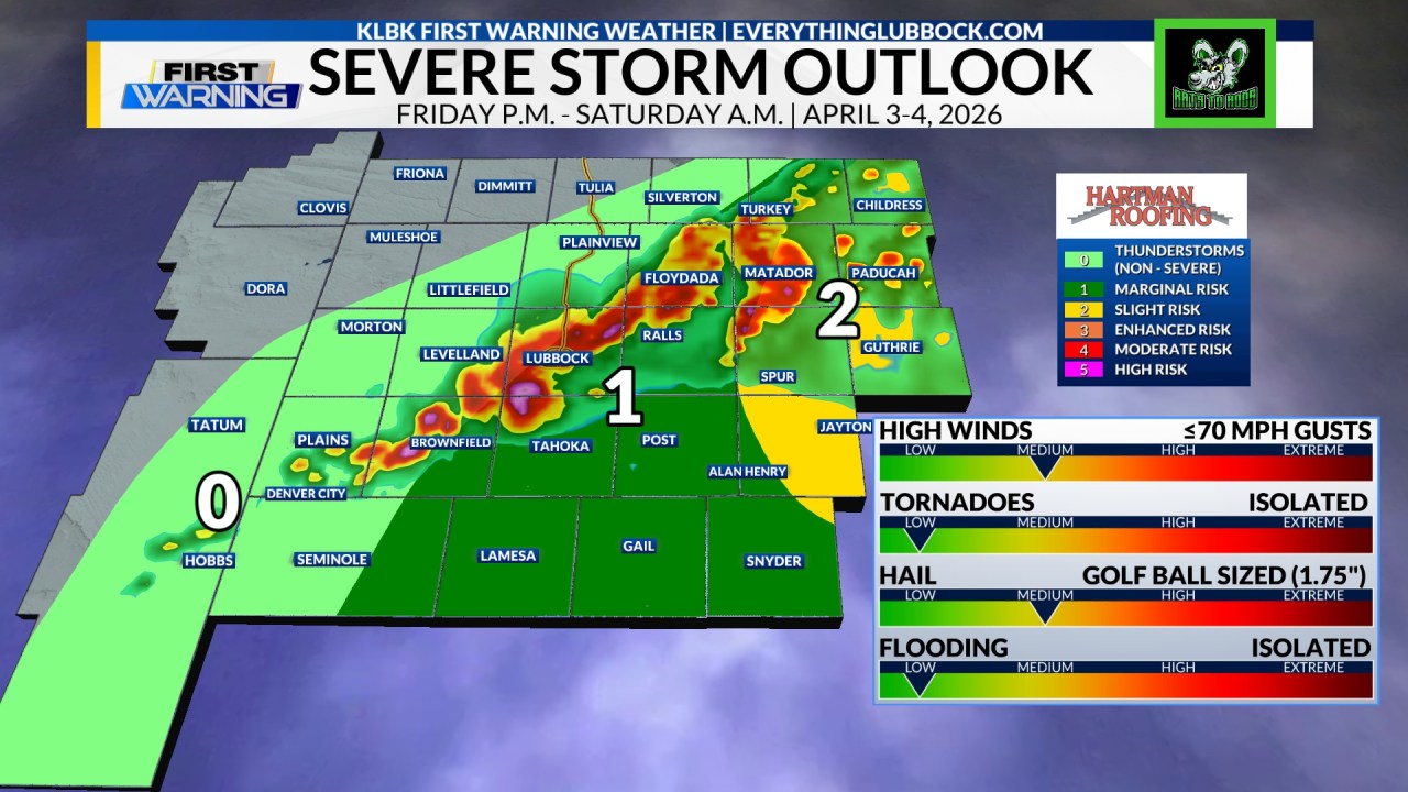
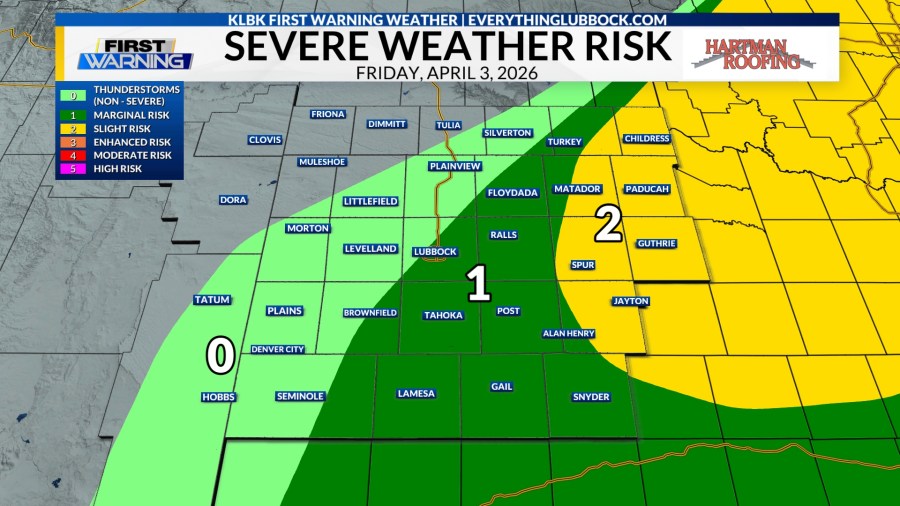
A level 2 out of 5 slight risk of severe storms has been issued for areas in yellow. This includes the cities of Childress, Matador, Paducah, Spur, Afton, Dickens, Guthrie, Jayton and Clairemont. A level 1 out of 5 marginal risk for severe storms has been issued for areas in dark green. This includes the cities of Turkey, Quitaque, Floydada, Ralls, Crosbyton, Kalgary, White River Lake, Lubbock, Lorenzo, Idalou, Ransom Canyon, Wolfforth, O’Donnell, New Home, Tahoka, Post, Slaton, Lake Alan Henry, Brownfield, Lamesa, Gail, Lake J.B. Thomas, Snyder, Fluvanna and Hermleigh. Severe storms are most likely within the level 2/5 slight risk, but will remain possible in the level 1 marginal risk areas as well. Once again, not everyone will see severe weather, let alone rain. Those that do see some could also see some locally heavy rainfall.
 Day 1 Categorical Severe Weather Outlook | Valid as of 7 PM CDT Friday, April 3, 2026.
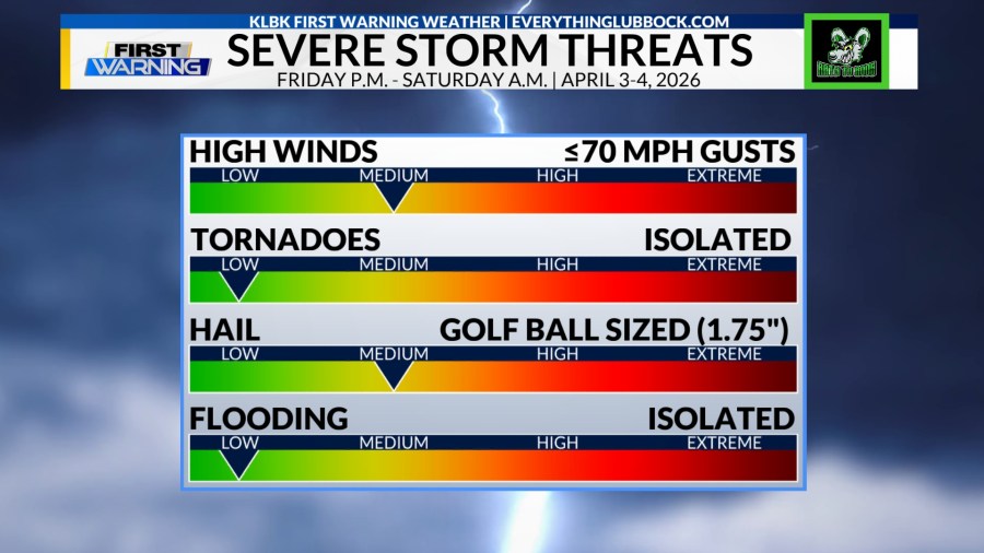
The primary concern with any storms that develop will be damaging wind gusts upwards of 70 MPH, and damaging hail up to golf ball sized (1.75″ in diameter). While not our greatest concern, an isolated tornado cannot be completely ruled out. The aforementioned areas have the potential to see severe weather, but it is most likely to occur along and east of U.S. Highway 385, which essentially runs from Dimmitt to Seminole. Localized flash flooding – while not likely – could occur in places like Lubbock or other city centers where heavy rainfall occurs within a short period of time. Again, not everyone will see severe weather. However, the strongest storms that do develop through the rest of the evening and overnight hours will be capable of producing the aforementioned threats.
 Severe Storm Threats | Valid as of 7 PM CDT Friday, April 3, 2026.
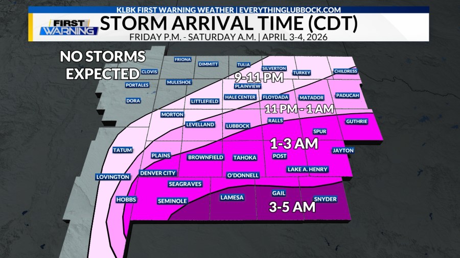
When it comes to storm arrival times, the main batch of activity looks to begin to develop initially over northeastern areas around the 8-9 PM CDT time frame. This activity will expand in coverage to the south-southwest, as individual storms also track to the east-southeast. The main line of storms will be tracking south-southeast out of the Texas Panhandle, developing as it moves into the northern locations this evening. This activity will continue to organize and strengthen, eventually expanding in coverage and bringing mainly areas along and east of U.S. Highway 385 areas of measurable rainfall. Again, these are the expected arrival times for storms. Storms will linger for some areas outside of the timeframes listed below. Also, not everyone will see severe weather, let alone rainfall.
 Expected Storm Arrival Timeline | Valid as of 7 PM CDT Friday, April 3, 2026.
Here is a look at one forecast model’s hypothesis as to what could occur with storms Friday evening through Saturday morning. Don’t take this as 100% truth, but rather pay attention to the general areas that will see activity, in addition to the rough time frame impacts could occur.
HRRR 22z Future Radar Hypothesis | Valid as of 7 PM CDT Friday, April 3, 2026.
As always, you can stay up to date with the latest information on Facebook, X, or on our website at everythinglubbock.com/klbk-weather/. If you don’t have it yet, make sure to download our new and improved EverythingLubbock Weather app. It is free in both the Google Play and Apple App stores. The EverythingLubbock Weather app is a great tool to have during severe weather.
Have a fantastic rest of your Friday, South Plains. Stay Weather Aware, and stick with KLBK!
-Jacob
Facebook: Chief Meteorologist Jacob Riley
X: @jrileywx