

LUBBOCK, Texas (KCBD) – Rain today, as expected, has been very spotty and very light. These showers, mostly sprinkles, will end by late evening. A much better potential for rain, and possibly severe storms, is on the way.
Light rain showers dot the Lubbock and West Texas area this evening, though most will just be sprinkles. If you’re heading out, you might not even need an umbrella, but might want to keep one handy just in case.
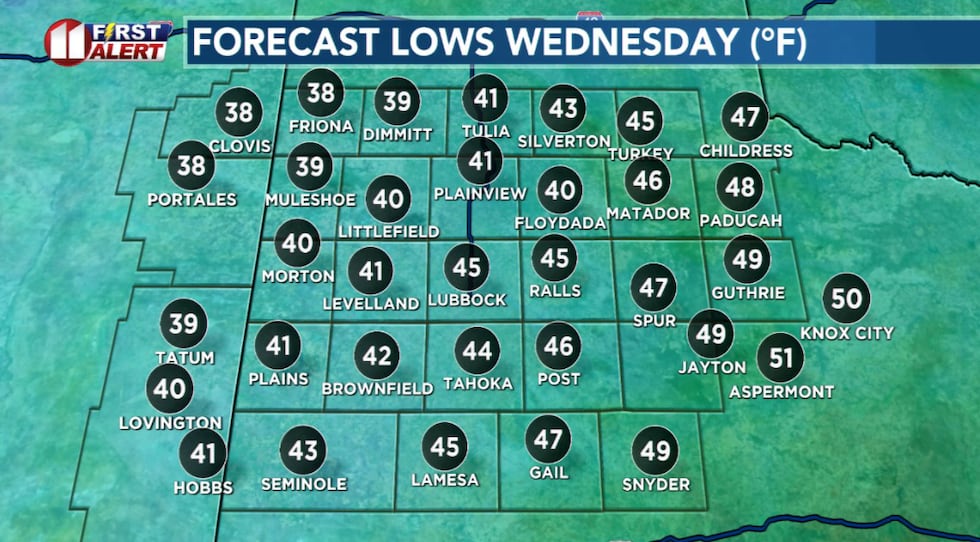 Chilly overnight but temperatures be near to what we typically see this time of year.(KCBD First Alert)
Skies will gradually clear out late tonight, and while it will be chilly overnight, temperatures will stick close to what we typically see this time of year.
Warmer Wednesday
Wednesday is shaping up to be a nice day. Skies will be sunny, and temperatures will climb into the mid- to upper 70s across the KCBD/FOX34 viewing area. A bit of a breeze, about 10 to 20 mph, will develop.
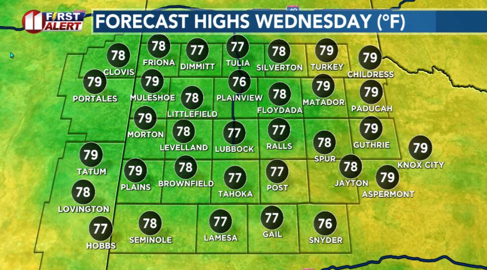 Much warmer under a sunny sky Wednesday afternoon.(KCBD First Alert)
Overall a good day to run errands or enjoy the outdoors before things get more active later in the week.
Slight Storm Chance
The pattern becomes more unsettled as we head toward the end of the week. There’s a slight chance for a few thunderstorms to develop late Thursday afternoon and again late Friday, mainly on the Caprock, which includes the Lubbock and Plainview areas.
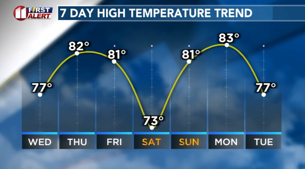 Much warmer afternoons before rain this weekend.(KCBD First Alert)
The threat for rain or a storm at any given spot will be low, but we’ll be watching it. If storms do develop, the main concern will be strong wind gusts and possibly some large hail.
Both days will feature warmer afternoons. Temperatures will peak around 80 to 82 degrees. Other than possible storm-related winds, I expect just a bit of a breeze, generally around 10 to 20 mph at times.
Strong Storm Potential
Rain and thunderstorms are expected in the area Saturday, and some could be severe. Some may also bring downpours, which could lead to localized flooding.
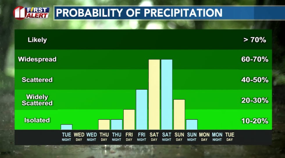 Rain, and possibly severe storms, currently are expected this weekend.(KCBD First Alert)
Make sure to stay alert and avoid driving into flood waters if you encounter them.
Lingering Storms, Then Windy
Storms and showers may linger into Sunday, though the main action will shift more toward the eastern part of the viewing area. Some of these storms could also be severe.
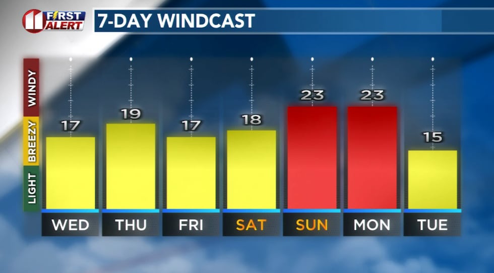 Breezy days ahead before the West Texas Wind Machine ramps up early next week.(KCBD First Alert)
As the day goes on, expect increasing wind and a warm afternoon.
Remain Weather Aware
An active weather pattern is setting up for the latter half of this week and into the weekend. Conditions could change, so keep checking back with us for the latest forecast. We’ll continue to monitor the situation and provide you with updates as the weekend approaches.
 KCBD Rain Gauge Grand Prize(KCBD)
On This Date
On this date in 1959, a likely tornado caused heavy damage to a bowling alley south of Denver City. No injuries were reported. Small hailstones also occurred with this storm. Either the same storm or a different one altogether produced a funnel cloud 15 miles northwest of Lubbock later that afternoon.
(Source: National Weather Service, Lubbock)
Copyright 2026 KCBD. All rights reserved.