
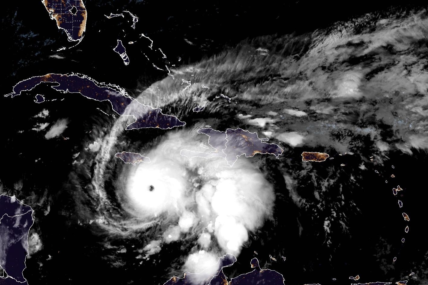
This weather satellite photo of the Caribbean Sea shows a clearly defined eye in the center of an organized Hurricane Melissa south of Jamaica last October. Melissa was the only major hurricane to make landfall during the 2025 season, reaching Jamaica as a Category 5 in late October.
Geostationary Operational Environmental Satellites/CIRA and NOAA
One of the nation’s most widely trusted and highly regarded hurricane season forecasts is predicting slightly below-average activity in the 2026 Atlantic hurricane season, largely because of a developing El Niño in the equatorial Pacific, where waters are growing much warmer than normal.
The outlook from the hurricane research team at Colorado State University is calling for only 13 named storms, including six hurricanes — two of which would be “major” or packing maximum sustained wind speeds of more than 110 mph. This projection, over the six-month hurricane season that runs from June 1 through Nov. 30, would fall short of the long-term average of 14 named storms, seven hurricanes and three major hurricanes.
The CSU forecast, which has been published every April since 1995, was released Thursday and is the first authoritative hurricane season outlook issued this year. The National Oceanic and Atmospheric Administration typically releases its official outlook in late May.
Article continues below this ad
ACCUWEATHER OUTLOOK: AccuWeather’s 2026 hurricane season forecast is out. Here’s what it means for Texas.
1. El Niño expected to limit storm activity
The primary reason for the muted outlook is the anticipated development of a moderate to strong El Niño, a naturally occurring climate pattern that typically suppresses hurricane formation in the Atlantic.
This diagram from the National Oceanic and Atmospheric Administration shows the typical influence El Niño has on hurricane season.
NOAA
Although El Niño is marked by above-normal surface temperatures in the Pacific, the world’s largest ocean, it can increase upper-atmospheric winds over the Caribbean and Atlantic. Those winds create vertical wind shear — a disruptive force that makes it harder for storms to organize and intensify.
Article continues below this ad
“While the average of our analog seasons is somewhat below normal, the large spread in observed activity … highlights the high levels of uncertainty,” said Phil Klotzbach, a senior research scientist at CSU and lead author of the forecast.
The tropical Pacific is currently in a weak La Niña phase, which is essentially the opposite of El Niño. Researchers expect a rapid transition to El Niño in the coming months, with the strongest effects likely occurring between August and October, the peak of hurricane season.
2. Atlantic waters show mixed signals
Sea-surface temperatures across the Atlantic are sending mixed signals.
Article continues below this ad
Waters in the western Atlantic also are warmer than normal, which can fuel storm development. However, parts of the eastern Atlantic, where many tropical cyclones originate, remain slightly cooler, and that tends to suppress activity.
This map of the Atlantic basin shows where sea-surface temperatures are above normal (orange and red) and below-normal (blue and green). The western Atlantic basin, including the Caribbean Sea and Gulf of Mexico, are running warmer than long-term average temperatures there.
WeatherBELL
Taken together with the expected El Niño, those competing factors have led researchers to project a season at about 75% of average activity based on historical data from 1991 to 2020.
3. Early forecasts carry high uncertainty
CSU researchers emphasized that April forecasts are among the least certain issued each year because ocean and atmospheric conditions can shift significantly before the peak of the season.
Article continues below this ad
The team compared 2026 to past seasons such as 2006, 2009, 2015 and 2023 — years that ranged from below-average to somewhat above-average activity. One of those seasons, 2023, brought Tropical Storm Harold to the Texas Gulf Coast, where it made landfall.
“It takes only one storm near you to make this an active season for you,” CSU atmospheric scientist Michael Bell said.
4. Landfall risk remains on Gulf Coast
Despite the below-average outlook, the forecast still indicates a 20% chance of a major hurricane making landfall along the Gulf Coast, including Texas. The projection is only slightly below the historical average of 27%.
PREPARE NOW: Check out the Houston Chronicle’s Hurricane Guide to help you prepare for whatever the season brings Texas.
Article continues below this ad
The probability for the entire U.S. coastline is 32%, compared with a historical average of 43%.
CSU researchers also noted that El Niño years tend to reduce storm activity in the western Atlantic, where most landfalls occur, further lowering risk compared to La Niña years.
5. Forecast draws on global models, AI tools
The CSU team used a combination of statistical models and major global forecasting systems, including those from leading international weather agencies.
For the first time, researchers also incorporated a machine learning-based climate model known as the Ai2 Climate Emulator, part of a growing effort to use artificial intelligence in seasonal forecasting.
AI AND FLOODING: Will AI help us solve Houston’s flooding issues? Texas A&M researchers hope to find out
While one statistical model suggested slightly above-average activity, the broader set of models, including the new AI system, pointed toward a quieter season overall.
6. Residents urged to be prepared, vigilant
Even in a quieter year, Gulf Coast residents are urged not to let their guard down. A single storm can define a season for coastal communities, particularly in Southeast Texas, where rapid intensification and flooding remain persistent risks.
ARE YOU READY?: Here’s what to put in a hurricane emergency kit
Now is the time when those in damage-prone areas should stock up and fill emergency kits. A home emergency kit should consist of a go-bag in case of an evacuation order and a shelter-in-place kit for situations when you can’t flee and must wait out the hurricane. Preparing the kit in advance means avoiding overcrowded stores with last-minute shoppers all trying to get their hands on the same supplies.
The CSU researchers will update their forecast three more times this season — in June, July and August — as the observed data and forecast modeling become clearer.