
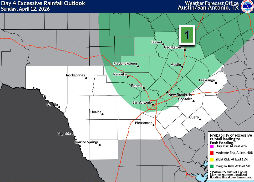
A Level 1 of 4, or at least a 5% risk of excessive rainfall has been issued for the Hill Country and the Interstate 35 corridor on Sunday.
nws austin/san antonio
A soggy weather pattern is setting up across South Texas, and it will result in daily rain chances in San Antonio from Friday and through the weekend. A few storms could even turn strong to severe by Sunday, as a system of low atmospheric pressure over the western United States moves closer to Texas.
If you have any big weekend plans, you’ll definitely want an umbrella. Thankfully, rain is not expected to last all weekend, as we will still have several dry periods. However, the dry weather will likely be interrupted by bursts of potentially heavy rainfall, some of which could produce isolated flooding. Here’s the latest information.
Article continues below this ad
Friday’s forecast
A few showers and weak storms are possible Friday early in the morning. Give yourself extra time for your commute, as even light showers can make roadways wet and dangerous for drivers. San Antonio’s rain chances are about 40% between 5 and 9 a.m.
Morning temperatures will be relatively mild, likely hovering in the mid- to upper 60s across Central and South Texas. Temperatures will rise slowly under cloudy skies and expected to reach only the mid- to upper 70s.
Shown are the expected afternoon temperatures, left, as well as the potential future weather radar for South Texas at 4 p.m. Friday.
Pivotal Weather
Rain chances are expected to peak later in the day, especially between 3 and 8 p.m. During this time, a few storms could produce locally heavy rainfall, with isolated totals of more than an inch possible. Most of us, though, will pick up less than a half-inch of rain throughout the day.
Article continues below this ad
Thankfully, atmospheric instability will be relatively low, which will keep storms from becoming too intense. The strongest cells still could produce very small hail and gusty winds, but severe weather is not anticipated on Friday.
Strong weekend storms
Another round of scattered showers and storms is possible Saturday morning and into the afternoon. Once again, rainfall will not last all day, and the overall chance of more rainfall for the San Antonio metro area will be around 50%-60%.
Article continues below this ad
Stronger, potentially severe thunderstorms are likely to develop across parts of West Texas on Saturday, affecting areas such as Midland-Odessa, Lubbock and San Angelo. There, large hail and even a few isolated tornadoes will be possible. A few of these stronger storms will move eastward overnight, possibly affecting parts of the northern and western Hill Country.
By Sunday, the risk of strong to severe storms will shift east and could affect the Interstate 35 corridor from Austin to San Antonio. With higher atmospheric instability in place, a few storms could produce hail by the afternoon and evening.
The National Weather Service also has included San Antonio, the Hill Country and the I-35 corridor under a level 1 of 4 risk, or at least a 5% chance, of excessive rainfall on Sunday. That means isolated flash flooding will be possible, but it’s not expected to be widespread.
Article continues below this ad
Shown are the potential cumulative rainfall totals across the region through Sunday, according to the National Blend of Models.
Pivotal Weather
How much rain to expect?
This storm system has the potential to bring some very beneficial rainfall to San Antonio, a city running a rainfall deficit of nearly 4 inches below average for this year. According to the National Blend of Models, between 0.75 inch and 1.5 inches of rain is likely for the Alamo City over the next three days, with locally higher amounts of up to 4 inches possible, especially out in the Hill Country.
Article continues below this ad
Rain chances will decrease by early next week, but with plenty of atmospheric moisture still in place, a few isolated storms are still possible. Overall rain chances are 20%-30% from Monday through Wednesday.