
The chances South Central Texas, including San Antonio and the Texas Hill Country, will see severe storms continues to amplify. Rain should reach the region Friday, April 10, and intensify over the weekend, brining large hail and flash flooding threats to the region.
There’s already a low-level threat for isolated flash flooding or flooding of urban areas in San Antonio Friday. But by Saturday, severe storm odds are climbing.
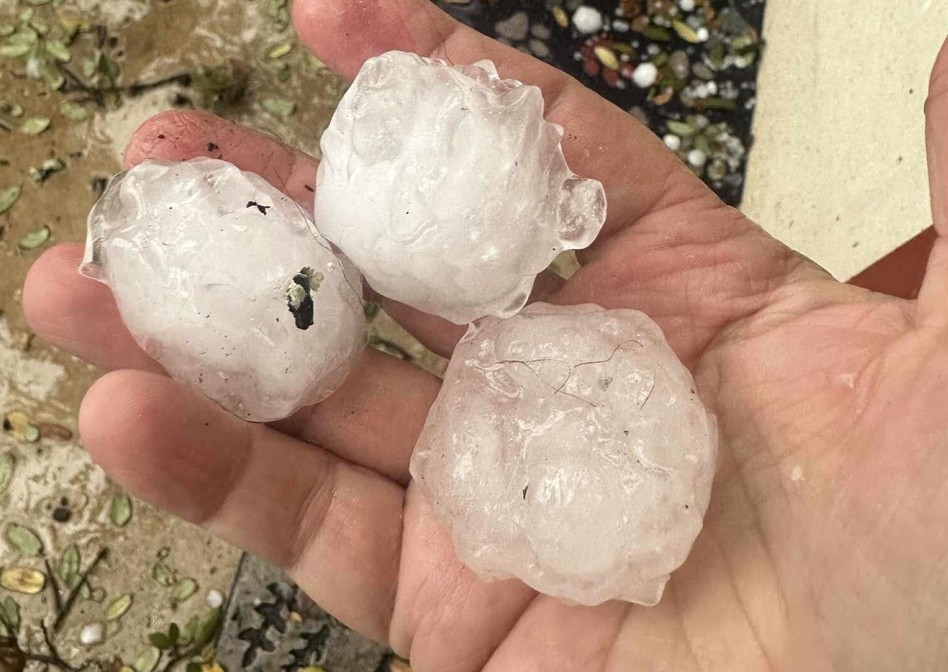
“Large hail and damaging winds would be the primary threat with this activity,” the National Weather Service Austin-San Antonio office warns, noting a system will blow in from West Texas Saturday night. Weather forecasters now place San Antonio and the Hill Country under a marginal risk for severe storms, while areas deeper into the Hill Country are at a higher risk.
Again these threats crop up in the area on Saturday night heading into Sunday morning, when another round of severe storm odds emerge. Excessive rainfall could lead to localized flooding around San Antonio, and forecasters warn large hail could hit again.
“Large hail and damaging winds would likely be the greatest severe hazards. Storms could produce heavy rainfall as well with rainfall rates enough that may result in isolated flash flooding,” the NWS says.
Original story:
The threat of severe storms over San Antonio, and South Central Texas overall, is ramping up quickly. In the latest from the National Weather Service, strong storms and flash flooding are most likely to hit the Alamo City on Sunday, March 12, after several days of rain clouds.
Storms began to roll in over South Central Texas Thursday. But days of doom and gloom are in the forecast as clouds linger over the entire weekend and well into next week. Now, forecasters say this continued dousing could lead to severe storms and flash flooding in San Antonio and the Texas Hill Country.
“This yields to the risk of some isolated to scattered severe thunderstorms, with a best focus along/north of the I-35 and Highway 90 corridor… Rainfall rates could become intense enough within these storms at times where an isolated risk for flash flooding will also exist,” the NWS Austin-San Antonio office warns for Sunday, noting severe storms throughout the weekend could hit north of the region.
At the tail end of the weekend, the Texas Hill Country all the way into the northern half of San Antonio could see some severe storms. The National Weather Service defines a severe storm as any event that produces hail 1 inch or greater in diameter or wind that’s 58 mph or stronger. Winds are considered “whole gale” at that speed and can cause “considerable structural & vegetative damage, especially no roofs.”
In an outlook sent out Wednesday, the national forecaster predicted the Texas Hill Country and upper half of San Antonio has a 15% to 29% chance of seeing severe storms develop Sunday. When it comes to excessive rainfall, San Antonio and Austin both have at a marginal risk of seeing flash flooding that day.