
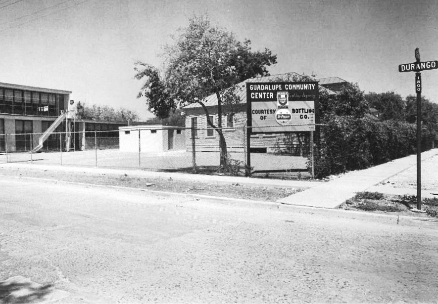
The Guadalupe Community Center, shown here in 1956, was one of the landmarks of Durango Street (later Boulevard). Its current address is 1801 W. Cesar E Chavez Blvd.
UTSA Special Collections
The Nathan Mitchell house, in 1967 at the northeast corner of South Presa and Martinez streets, was one of the old structures lost when Durango merged with Martinez and Victoria to make a wider, continuous east-west boulevard before HemisFair ’68.
UTSA Special Collections
A new sign, sponsored by the Zachry Foundation, marks the new name of the entryway to Hemisfair in Civic Park. Aro de Abrazos, or “circle of embraces,” refers to the shape of the entry and the welcoming nature of the design.
Courtesy of Zachry Corp./James Barrett
From left to right, Bob Shemwell, Andi Rodriguez, Susan Thompson, Tracy Watts, Sue Ann Pemberton and David Zachry all were involved in the realization of the new Aro de Abrazos entryway at Hemisfair, which opened to the public last month.
Courtesy of Zachry Corp./James Barrett
Morrison & Fourmy’s 1883 Revised Map of San Antonio probably is the first map to show the newly renamed section of streets named for Mexican cities or states that included Durango. At that time, Durango only extended as far east as South Laredo Street.
Courtesy SACS Foundation
Durango Street sign at South Pinto.
UTSA Special Collections
This column doesn’t typically take sides on current issues. It has come out against San Antonio’s shabby Jim Crow-era treatment of a Black baseball great (March 18, 2023), false imprisonment during World War I of “wayward” women (Sept. 8, 2018) and some other bygone bad choices.
But recently, readers have written with suggestions about a current affair, the renaming of a street that had been renamed already – Durango Street, later Boulevard, changed in 2011 to César E. Chavez Boulevard. Now there are calls to change the name again, either back to the historical one or to honor a different namesake.
Article continues below this ad
You could do a lot worse than Durango – and we did.
Early last month, what would have been San Antonio’s 30th annual César E. Chavez March for Justice, scheduled for March 28, was canceled because of a “sensitive matter” that turned out to be claims of sexual assault by several women against Chavez, the founder of the United Farm Workers Union who died in 1993.
Since then, the city has addressed the possibility of a name change with a survey, community outreach and meetings, expected to lead up to a public hearing and consideration by City Council next month, according to a timeline proposed in a March 20 memo by Assistant City Manager John Peterek, whose portfolio includes Development Services, which is tasked with the potential renaming process.
That gives us all time to think about what we’ve done and try not to do it again.
Article continues below this ad
RELATED: Southtown street namesake
San Antonio’s oldest streets were named for “the places they led to, how they looked, who lived on them or what happened there,” says David P. Green in “Place Names of San Antonio.” By the late 19th century, some areas beyond the traditional city center picked up theme names such as Alamo heroes, American cities or states, trees and vines or Mexican cities.
Durango was one of that last group, along with Laredo, Matamoros, Monterey, Puebla and Saltillo. Another one was El Paso, not for the Texas city but for what’s now Ciudad Juarez, known as El Paso del Norte until 1888, as noted by Beth Standifird, the San Antonio Conservation Foundation’s research librarian who has compiled a chronology of Durango-related events.
Themed names like these brought a kind of organization to street naming. You were meant to know you were headed southeast of downtown if you set off for Florida Street, or just north of downtown to Baltimore Avenue.
Article continues below this ad
The Mexican-cities theme was adopted between 1877 and 1883, renaming streets on an earlier grid pattern for streets west of San Pedro Creek that alternated numerical and directional names. According to research by local historian Maria Pfeiffer, “Third became Monterey, Fourth became Matamoros and Fifth became Durango.”
This homage may have been intended to highlight San Antonio’s economic ties across the border.
“The Mexican trade of this city is a heavy item in its business,” says the boosterish introduction to the city directory for 1879-1880. “Our merchants have dealings with all the principal cities of Mexico. “With care, this trade can be largely increased, and the wealth derived therefrom would alone be sufficient to resist the depressing effects of the most disastrous panic which could occur in the North.”
The first newspaper reference to Durango as a street name was in the San Antonio Daily Light, April 24, 1882, and its first appearance in the city directory came in the 1883 volume (probably compiled during the previous year).
RELATED: Street names after family properties
Article continues below this ad
Over the years, with some extensions, Durango grew into a vital connector between the West and East sides. Now 5.5 miles long, the street renamed for a now-tarnished civil-rights leader runs from Southwest 36th Street to South Hackberry Street, skirting the southern edge of downtown and crossing City Council districts 1, 2, 5 and 6.
Merged with Martinez and Victoria streets in the mid-1960s, the street ran between interstates 35 and 37 and after a relatively small section was widened and improved, it became known as Durango Boulevard and appeared as such on 1968 maps.
During the runup to the HemisFair ’68 world’s fair, there were proposals to change the name to HemisFair Boulevard or for a small portion to become the Avenue of Heroes, with a “structure” displaying the names of local greats. Both were nixed, as was a suggestion to turn Broadway into the Avenida de las Americas, in keeping with the fair’s Confluence of Civilizations in the Americas theme.
By the turn of the last century, there was a trend to rename streets or at least parts of them after organizations then located there. “In defense of the city’s 1881 naming of streets for cities in Mexico, the (San Antonio) Conservation Society kept a section of Laredo Street from being named Goodwill Way in 2005,” says Lewis F. Fisher in “Saving San Antonio: The Precarious Preservation of a Heritage.”
Article continues below this ad
RELATED: Streets named after farmers, Texian Army descendant
“Society opposition in 2003 led City Council to reverse its decision to rename Durango Boulevard in honor of the late Judge Hipolito Garcia, making that an honorary designation instead.” In 2005, the federal building and courthouse was named after Garcia (1925-2002), who served on the U.S. District Court for the Western District of Texas from 1980 until his death, according to the U.S. General Services Administration website.
Later, the group would successfully protest the change of part of El Paso Street to Cafecollege Drive and part of Perez Street to Robert B. Green Way, despite requests from the city’s Department of Human Service and University Health System.
The one the preservationists lost was the proposal to rename Durango after Chavez, whose name had been proposed in 1999 for Commerce Street. At that time, the downtown street received an unofficial designation for the California-based labor leader, there was unpopular talk of naming the airport after him, and Durango first was mentioned as an alternative.
Article continues below this ad
“Proponents of the name change argued that Durango Boulevard did not represent any particular individual or family and therefore, the name itself was not historically significant,” said Melissa Gohlke in the April 26, 2012, Top Shelf blog, published by UTSA Special Collections. “A judge ruled in favor of City Council, and in July 2011, Durango Boulevard officially became Cesar E. Chavez Boulevard.”
Where do we go from here? Either keep the tainted name, change it to that of another hero who might not be perfect either – or bring back Durango, surrounded by other streets with similar names that aren’t bothering anybody.
PARK PORTAL: A few blocks from the Boulevard That Must Be (Re-) Named is Hemisfair, the series of public spaces on the approximate site of the former HemisFair ’68 world’s fair grounds.
The official name of the new entrance to Hemisfair’s Civic Park at Market and South Alamo streets has been announced as Aro de Abrazos or “ring of embraces.” According to a press release shared by a spokeswoman for the project, supported by the Zachry Foundation, the name “reflects the area’s circular design and its purpose as a welcoming space for shared experiences.”
It’s also a nice callback to HemisFair’s Club Abrazo (covered here July 5, 2013), a VIP club for entertaining prominent visitors to the fair.
Something that’s not coming back, however, is the medieval-adjacent, green arched sign that marked the South Alamo entrance to Hemisfair Park from 1988 until 2015. Not part of the 1968 fairgrounds, it was a staple background for festive photos until it was dismantled and removed during the ongoing reimagining of the area.
Though the arch was said at the time to be in storage – never a good sign for public art – it was in no condition for a return.
“The light-gauge steel structure was rusting through,” said former Hemisfair CEO Andres Andujar. “It would have had to come down sooner or later for safety concerns.”
Article continues below this ad
Through the spokeswoman, the current Hemisfair team adds that the old arched sign “is no longer intact, so there are no plans to showcase it (but) there are plans to create more long-term monument signage that honors Hemisfair’s past while giving locals and visitors a distinct feeling that they are in the Hemisfair District at key entrances to our urban parks district.”
historycolumn@yahoo.com | X (formerly Twitter): @sahistorycolumn | Facebook: SanAntoniohistorycolumn