
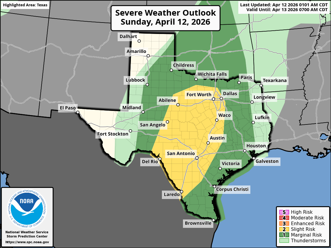
Much of Southeast Texas is under a Level 1 of 5 risk of severe thunderstorms on Sunday.
Storm Prediction Center
Active weather is expected across much of Texas on Sunday, as a low-pressure system from the west collides with deep moisture moving north out of the Gulf of Mexico.
The heaviest rain, along with the highest potential for severe thunderstorms, will stay across Central and North Texas. That said, a few strong storms are possible across parts of Southeast Texas, where a Level 1 of 5 risk of severe thunderstorms has been issued by the Storm Prediction Center. Here’s an overview of what you can expect.
Shown are the potential rainfall totals across Southeast Texas through Sunday. Totals in Houston are expected ton be very light, with heavier rain possible to the north and west.
Pivotal Weather
Sunday’s forecast
Morning: Mild, humid, and cloudy conditions are expected across Houston as Sunday gets started. Temperatures will hover in the low 70s through 9 a.m., rising very slowly into the upper 70s by the middle of the day. A few isolated showers are possible, but rain chances will only be around 20% through the morning hours.
Article continues below this ad
As you move north across the state, rain chances will be much higher. In fact, a cluster of strong storms is likely to move across the DFW and Waco areas during the early morning hours, progressing eastward by the middle of the day. Much of this moisture, however, will stay far from Houston.
Afternoon: Temperatures are expected to rise steadily, reaching high temps in the low 80s across Southeast Texas. The daytime heating will likely help spark a few scattered thunderstorms across the region.
Shown is the potential timing of the strong to severe storms possible across Southeast Texas on Sunday
NWS Houston/Galveston
The highest chance of thunderstorms is expected to stay north and west of Houston, in cities such as Crockett, Huntsville and College Station. Here, overall rain chances will rise to around 60 to 70% during the afternoon and evening. A few storms could be strong, too, capable of hail and damaging winds gusts.
In Houston, storm chances are lower. However, there will still be a chance of a few scattered showers and thunderstorm, particularly between the late afternoon and evening. Rainfall totals, if any, are expected to be light, with most areas likely to see less than a quarter-inch of precipitation. Houston’s overall rain chance is only about 40%, so not everyone will see rain.
Article continues below this ad
After 8 to 9 p.m., rain chances will fall to around 20% or less, making for a relatively pleasant night, Temperatures will hover in the 70s as south winds move in at just 10 mph.
What’s coming next?
During the upcoming week, persistent southeast winds will bring warm, humid air into Southeast Texas. Despite the added moisture, rain chances will remain very low as high pressure builds over the central Gulf of Mexico. The result will be a stretch of quiet, warm, and muggy weather across the region.
On Monday, expect morning lows in the low 70s, with temperatures climbing into the mid-80s by the mid- to late afternoon. An isolated shower can’t be ruled out near the coast, but most areas will stay dry.
Article continues below this ad
That same pattern holds from Tuesday through Thursday. Highs will consistently reach the mid-80s, while the high humidity will keep mornings mild and muggy, with lows only dropping into the low 70s each day.
Rain chances will finally start to pick up again by next weekend, as another low-pressure system will begin to traverse the Central Plains.