
A Rice University study warns that Houston neighborhoods outside flood zones could still face rapid flooding during extreme storms.
Houston Chronicle/Hearst Newspap/Houston Chronicle via Getty Imag
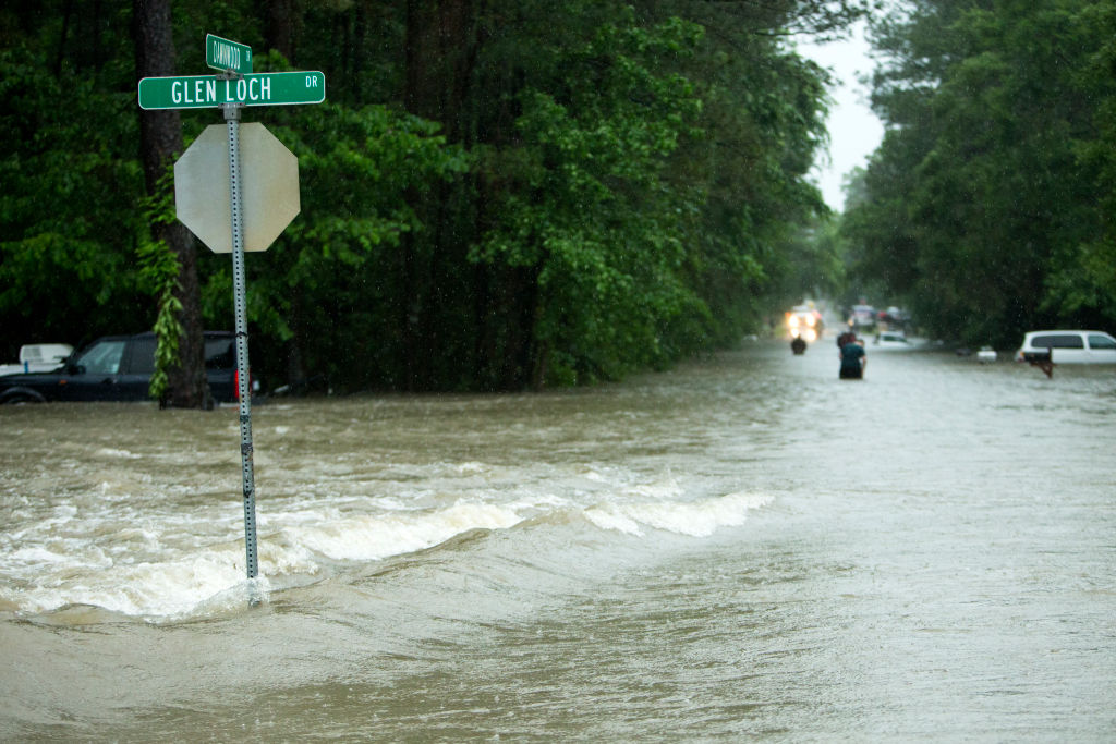
About 10 years ago—on April 17, 2016— the Tax Day flood caught Houston off guard, dumping over a foot of rain across parts of the region and overwhelming bayous and neighborhoods many residents had never considered at risk.
Now, new research suggests even “safe” areas were never truly safe.
Article continues below this ad
Researchers at Rice University’s Center for Coastal Futures and Adaptive Resilience (CFAR) recently simulated what could happen if a Tax Day-level storm struck more densely populated parts of the city.
“The most striking takeaway wasn’t just the depth of the water but how quickly it overwhelmed areas we’ve traditionally labeled as ‘safe,'” Dominic Boyer, professor of anthropology and co-director of CFAR explained. “The water didn’t just rise. It rapidly flooded neighborhoods with little warning, leaving little time for traditional emergency response.”
Researchers say that speed and intensity are exactly what make these storms so dangerous—and so difficult to plan for. Unlike longer-duration events that give cities time to mobilize, these sudden downpours can overwhelm drainage systems before warnings even register.
Motorists inch past White Oak Bayou, which was flooded up to the freeway at Quitman and North I-45, Monday, April 18, 2016, in Houston. ( Karen Warren / Houston Chronicle ) (Photo by Karen Warren/Houston Chronicle via Getty Images)
Houston Chronicle/Hearst Newspap/Houston Chronicle via Getty Imag
“Harvey was a marathon of misery. The Tax Day storm was a sprint,” Boyer added. “These shorter but incredibly intense deluges are in some ways harder to prepare for because they don’t give the city days to mobilize.”
Article continues below this ad
But the most alarming implication of the Rice simulation is not just how fast water rises—it’s where it could go next. Their simulation suggests that if a storm of similar intensity were to shift slightly in location—hitting denser parts of Houston—the outcome could be far more disruptive.
Rice researchers say the intensity is something many flood maps and planning tools still struggle to capture.
Alex Sanchez looks through the window of his stranded car at the North Main Street exit off of North I-45, as White Oak Bayou comes out of it’s banks, flooding the freeway, Monday, April 18, 2016, in Houston. ( Karen Warren / Houston Chronicle ) (Photo by Karen Warren/Houston Chronicle via Getty Images)
Houston Chronicle/Hearst Newspap/Houston Chronicle via Getty Imag
People wade through high water from their flooded apartment complex Monday, April 18, 2016, in Houston. ( Steve Gonzales / Houston Chronicle ) (Photo by Steve Gonzales/Houston Chronicle via Getty Images)
Houston Chronicle/Hearst Newspap/Houston Chronicle via Getty Imag
“It reveals that our flood maps are still looking in the rearview mirror,” Jim Elliott, the David W. Leebron Professor of Sociology and co-director of CFAR noted. “We are essentially using 20th-century statistics to prepare for 21st-century deluges.”
Article continues below this ad
The study also points to a growing challenge for cities like Houston, where rapid development and shifting population patterns continue to change how water moves across the landscape. Traditional flood zones, often based on historical data, may not fully reflect how modern storms behave in a built environment.
“In Houston, ‘not in a flood zone’ is a dangerous misnomer,” Yilei Yu, senior researcher at CFAR and postdoctoral fellow said. “The lines on a FEMA map are often actuarial, not physical. Even if you technically live outside the 100-year flood zone, you are still at risk.”
In other words, it’s not enough to look for a home in an area that isn’t a flood zone.
“Regardless of what the latest FEMA maps say, get flood insurance,” Yu said bluntly. “The map isn’t a wall.”
Article continues below this ad
Ten years after the Tax Day floods, the unease in Houston hasn’t gone away—it has evolved. With every heavy rain or thunderstorm (especially during hurricane season), our shoulders tense up over what it might evolve into.
“We often talk about floods as ‘acts of God’ or ‘freaks of nature,'” Boyer said. “But the increasing intensity and suddenness of extreme rainfall in our region is part of our new normal. The question is whether we are willing to plan for it before it happens again.”
Rice researchers also add that future planning will need to account not just for where flooding has happened, but where it could happen next—especially in neighborhoods that have not historically seen high water.
Article continues below this ad
“We need to stop asking how we can stop the water and start asking where the water is going to go when the next extreme event happens,” Elliott said.