
We just cannot ever seem to get a nice, easy rain without somebody getting too much of it.
Tonight, that concern is growing from the eastern Hill Country into South Central Texas, including the San Antonio metro, New Braunfels, Seguin, Universal City, and nearby communities. Several spots in this region already picked up 3 to 5 inches of rain today, and more heavy rain may end up redeveloping over some of the same areas overnight.
That is why the flood threat is going up tonight.
Areas of greatest concern tonight
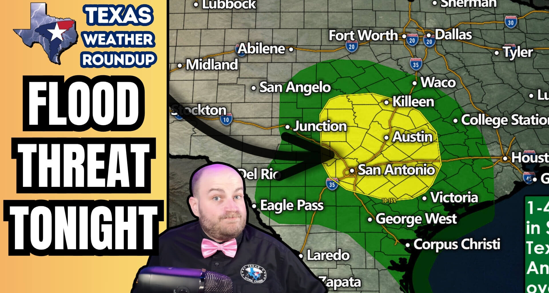
The part of the state we are watching closest runs from portions of the eastern Hill Country into South Central Texas, including places like Fredericksburg, Llano, Junction, Austin, Bastrop, San Antonio, New Braunfels, Seguin, and surrounding communities. Not every town in that zone is going to have problems, but where the heavier bands set up, flooding could develop in a hurry.
A Flash Flood Warning was already in effect earlier this evening for parts of the San Antonio to New Braunfels corridor, and that tells you this is no longer just a routine rainy day. We are dealing with places that have already taken on quite a bit of water, and now we may be looking at more storms moving over the same ground tonight.
Why the flooding risk is increasing
The issue tonight is not that everybody across Central and South Central Texas is going to get slammed by one giant shield of heavy rain.
The bigger concern is that we may see smaller bands of storms continue to develop and move across areas that are already saturated, especially from the north side of San Antonio up toward New Braunfels and parts of the eastern Hill Country. Once you have already had several inches of rain, it does not take much more to turn a manageable situation into flooded roads and fast runoff problems.
That is really what makes tonight different.
This is not about everybody having issues. It is about a more focused corridor potentially getting hit again before it has had any time to drain out.
How much more rain is possible tonight?
Forecast guidance suggests another 1.5 to 3 inches of rain may fall in the heavier bands tonight, with isolated higher totals up to 5 inches possible where storms repeat or train over the same areas.
And that is the part people around San Antonio and New Braunfels need to respect.
If those higher totals fall over areas that already picked up 2, 3, 4, or 5 inches today, then flooding issues can ramp up quickly. That is especially true in the more urban corridor from San Antonio toward New Braunfels, where runoff problems can escalate faster than they do in open country.
Main hazards tonight
The biggest concerns overnight are going to be flooded roads, rapid runoff, rising creeks and streams, and localized flash flooding.
Most of the problems tonight will probably begin with water-covered roads and low-lying trouble spots. But if the heaviest rain keeps targeting areas that were already soaked earlier today, then more serious flash flooding issues could develop overnight.
And as usual, nighttime flooding is a different animal. It is harder to see, easier to underestimate, and more dangerous when people try to drive through water they cannot judge in the dark.
It stays wet into Tuesday
This is not just a one-hour problem.
Through tomorrow morning and into early Tuesday afternoon, a broad part of the eastern half of Texas is expected to stay wet, including areas up through DFW, Texoma, Northeast Texas, the Brazos Valley, East Texas, Southeast Texas, the Coastal Plains, Austin, San Antonio, and parts of the Hill Country.
So while the most immediate flood concern tonight is focused on the eastern Hill Country and South Central Texas, a much larger part of the state is still going to be dealing with rain and thunderstorms through tomorrow.
That broader rain is not automatically a major problem. But for the places that have already taken on a lot of water today, it means there is not much margin left if heavier bands set up again tonight.
What people around San Antonio and New Braunfels should do tonight
If you live in or near San Antonio, New Braunfels, Seguin, Universal City, northern Bexar County, or the eastern Hill Country, tonight is a good night to stay weather-aware.
Do not assume a flooded road is passable just because it usually is.
Do not silence weather alerts if you live near a flood-prone creek, stream, low water crossing, or poor drainage area.
And if your neighborhood or property has a history of water issues, this is the kind of night where you need to pay attention before you go to sleep, not after the water is already rising.
Bottom line
The flood threat is increasing tonight from the eastern Hill Country into South Central Texas, especially around San Antonio, New Braunfels, and nearby communities.
Several areas already picked up 3 to 5 inches of rain today, and additional heavy rain may redevelop overnight. That could lead to more flooded roads, rapid runoff, and rising creeks and streams, especially in places that are already saturated.
This is a targeted flood concern, not just a generic rainy-night forecast.
If you are in a flood-prone area, keep warnings enabled overnight and be ready to move if conditions worsen.