
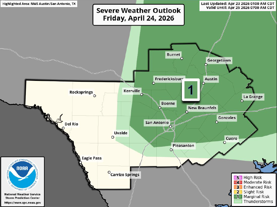
Much of Central and South Texas is under a low-end level 1 of 5 risk of severe thunderstorms on Friday.
nws austin/san antonio
While the steady rain has stopped, the atmosphere above South Texas is still packed with plenty of atmospheric moisture. So far, it has resulted in mostly cloudy skies and very humid conditions throughout the region.

That humidity will continue Friday and into the weekend, which could allow for humidity-driven heat index values to rise to nearly 100 degrees by Sunday. Before that, however, the elevated moisture is likely to result in a few isolated, strong thunderstorms. While coverage of these storms will be limited, a few could be severe, capable of producing large hail and damaging wind gusts.
Article continues below this ad
Friday’s forecast
Muggy, but relatively comfortable, weather is expected in San Antonio on Friday morning, leading up to the Battle of Flowers parade. Temperatures will hover near 70 degrees early in the morning, rising only into the mid-70s by the time the parade kicks off at 10:30 a.m.
Cloudy skies are expected during the parade, with just a 20% chance of an isolated shower or storm. Temperatures will rise to around 80 degrees by 1-2 p.m.
By the middle to late afternoon, a few isolated thunderstorms might develop across Central and South Texas. Overall storm coverage will stay low, with only about 20% of the region expected to see rain. However, the storms that do form could be in an environment where they can intensify quickly.
Article continues below this ad
The Interstate 35 corridor, including San Antonio, New Braunfels, San Marcos and Austin, has been placed under a low-end level 1 of 5 risk of severe thunderstorms. In this case, it means that most areas will stay dry, but a storm or two could produce isolated large hail and damaging winds.
The best chance of these isolated severe storms will occur between 5 and 10 p.m. Otherwise, expect temperatures topping out in the mid-80s before falling back into the 70s after sunset.
More storms Saturday?
Similar weather is expected Saturday morning, as temperatures will sit in the 70s under cloudy skies and muggy weather across the region.
Article continues below this ad
Skies will clear more efficiently by the afternoon, though, allowing temperatures to rise to around 90 degrees. When you incorporate the sky-high humidity, the heat index values, or the “feels like” temperatures that factor in the air moisture, could reach 98 degrees. If you plan on attending the King William Fair, be sure to stay properly hydrated throughout the day.
By the time of the Fiesta Flambeau parade, South Texas temperatures will be very warm, along with a slight chance of isolated thunderstorms.
WeatherBell/Pivotal Weather
By late Saturday afternoon and into the evening, a few isolated storms are likely to develop west of San Antonio and move east toward the city after sunset. The metro area will have about a 20% chance of storms between 8 and 11 p.m., which coincides with the Fiesta Flambeau parade happening downtown.
The overall chance of storms will stay low Saturday night. But if a storm does push into the metro area, it could be very strong. San Antonio has been placed under a level 1 of 5 risk of severe storms once again, so if you plan on attending the parade, stay tuned to expressnews.com/weather for updates.
Article continues below this ad
High heat incoming
Peak daily temperatures in the afternoon will continue to rise over the next few days. On Sunday, San Antonio will likely top out around 92 degrees, with maximum heat index values of 98 to 100 degrees. Monday and Tuesday could be a few degrees warmer, with heat index values of up to 102 degrees possible.
A weak cold front might push through by late Tuesday and into Wednesday. While it could bring temperatures down slightly, the main effect is likely to be an increase in storm chances. San Antonio will likely have a 20%-40% chance for storms by the middle of next week.
Article continues below this ad