

It is day three of dangerous severe weather impacting millions of Americans. FOX Weather meteorologist Haley Meier is live tracking storms from the FOX Weather Beast as the team intercepts a supercell that could produce a tornado.
More than 55 million people are in the threat zone for a dangerous weekend severe storm threat across the South and Central U.S., where giant hail, damaging winds have already been reported and strong tornadoes (EF-3+) remain possible.
Earlier in the evening, a confirmed tornado was reported in Archer City, Texas, as powerful supercells tracked through North Texas.
Meanwhile, tornado watches and warnings have been issued across parts of Oklahoma, Arkansas, and Texas. Additional warnings and confirmed tornadoes are expected as the evening continues.
THE SPC 5-POINT SEVERE THUNDERSTORM RISK CATEGORY SCALE EXPLAINED
This comes after a monster EF-4 tornado hit Enid, Oklahoma, on Thursday. Now, parts of the state are once again in the bull’s-eye of today’s severe weather.

Tornado tears across Vance Air Force Base in Enid, Oklahoma, on April 23, 2026.
(Clay Bowden via Storyful)
NOAA’s Storm Prediction Center (SPC) has issued a Level 4 out of 5 risk of severe thunderstorms over southeastern Oklahoma due to softball-sized hail (greater than 4 inches in diameter) and possible strong tornadoes developing this afternoon.
“This is the type of hail that shatters windshields and damages roofs,” the FOX Forecast Center said.
HOW ARE TORNADOES RATED? THE ENHANCED FUJITA SCALE EXPLAINED
Supercell thunderstorms capable of producing these kinds of giant hailstones, have started to form.
Additionally, tornadoes with up to EF-3 intensities, are expected to develop between 5 and 6 p.m. local time and could persist through the evening before weakening after midnight.
A broader Level 2 threat stretches from Kansas to parts of North Texas and the Ark-La-Tex region.
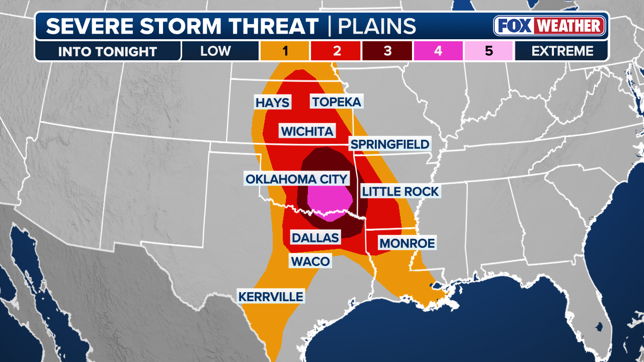 This graphic shows the severe storm threat in the Great Plains starting this weekend.
(FOX Weather)
Meanwhile, Tornado Warnings were ongoing early Saturday across parts of Louisiana — energy left over from Friday’s storms.
Severe weather even reached the Midwest Friday, including Indianapolis, where social media video showed tornado sirens blaring during a Severe Thunderstorm Warning Friday. Police said wind gusts were strong enough to knock down several trees onto local roads.
A 59 mph wind gust was clocked at Indianapolis International Airport Friday evening.
Tornado sirens blared across Indianapolis during a Severe Thunderstorm Warning Friday afternoon. Police said wind gusts were strong enough to knock down several trees onto local roads. A 59 mph wind gust was clocked at Indianapolis International Airport Friday evening.
According to the FOX Forecast Center, a deepening low will move across the Texas Panhandle throughout today, and a dryline will extend southward from it into the central and western parts of the state.
To the north, a warm front is expected to push northward across Oklahoma and northern Texas (the Ark-La-Tex region).
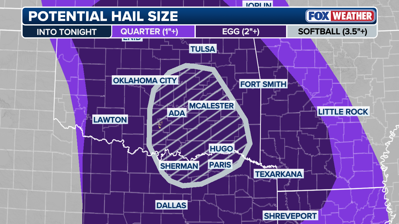 Potential hail size
(FOX Weather)
Strong instability along and east of the dryline, as well as near and south of the warm front, will be the areas to watch for storm development.
WHAT IS A DRYLINE FOR SEVERE WEATHER?
The greatest potential for strong tornadoes will be along and just south of the warm front, from Oklahoma City into southeast Oklahoma.
Hail greater than 3″ is also expected over portions of southeast Oklahoma and northern Texas.
Hail fell across Union, Missouri Thursday morning as severe storms shift east through the day. NOAA’s Storm Prediction Center says strong EF-2+ tornadoes are possible Thursday afternoon and evening across southern portions of Illinois and Indiana.
These storms could develop into supercells later in the night, posing a risk of very large hail and damaging winds.
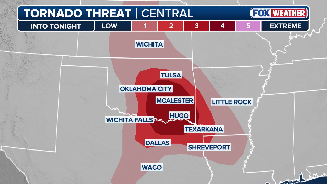 Most at risk of seeing a tornado
(FOX Weather)
SUNDAY’S THREAT ZONE
As the severe weather threat continues overnight and into Sunday morning, another area of low pressure is expected to move out of the Rockies and back into the Plains.
A level 3/5 severe storm threat extends from Central Kansas to Western Missouri for Sunday, with a broader level 2/5 severe threat extending from Southern Nebraska to Northern Texas.

next
A damaged home following a tornado in Enid, Oklahoma.
(Jarrod Maloney)

prevnext
Damage in Enid, Oklahoma, after a violent tornado.
(Jarrod Maloney)

prevnext
First light on Friday, April 24, 2026, reveals the extent of damage from a powerful tornado that ripped through Enid, Oklahoma.
(FOX Weather)

prevnext
Damage in Enid, Oklahoma, after a tornado ripped through the city just before 8:30 p.m. on April 23, 2026.
(KOKH)

prev
Damage to a farm in Enid, Oklahoma.
(Jarrod Maloney)
As the system intensifies, moist air and increased instability will be directed towards a warm front extending into Missouri and Arkansas.
As the severe storm threat develops, isolated to scattered supercells could develop along the dryline extending into South Texas by Sunday afternoon.
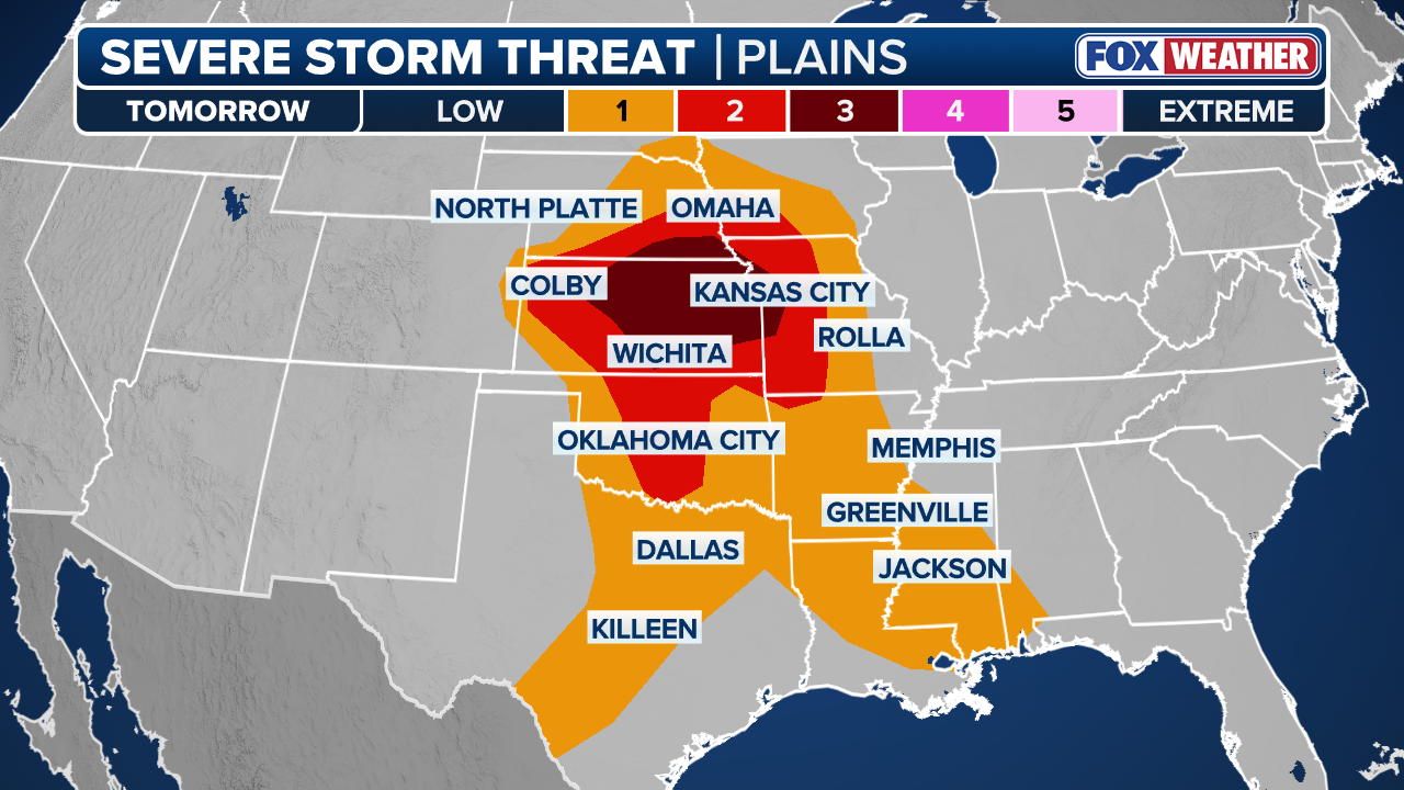 This graphic shows the looming severe storm threat in the Great Plains for Sunday.
(FOX Weather)
By the evening and into the overnight hours, storm development could expand, with an increasing potential for strong tornadoes, large hail and damaging winds.
Stay tuned to FOX Weather all weekend long as we continue tracking the development live of these severe storms.