
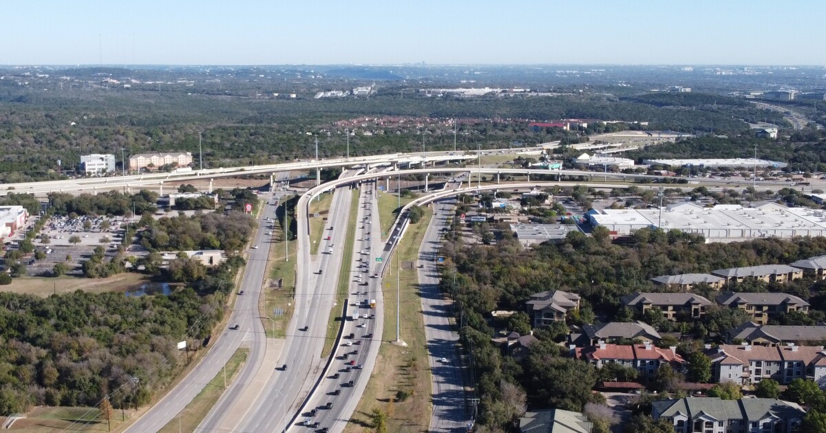
A new government review of the proposed MoPac South project lays out the most detailed picture yet of what the long-debated highway expansion would touch.
And it’s not just affecting MoPac.
The agency leading the project, the Central Texas Regional Mobility Authority (CTRMA), has issued a draft environmental assessment showing how construction would reach into public spaces including Zilker Park, how water quality could be affected and where noise walls could go.
Previous rounds of public feedback offered broader outlines of the proposal. Now, the public can read a 224-page draft environmental assessment, along with a stack of technical studies, spelling out the costs of the project and what CTRMA says drivers would gain in return.
The draft environmental assessment is open to public comment until 11:59 p.m. on Sunday, May 3.
Opponents say the new documents reveal why the current level of review still doesn’t go far enough. They argue the studies show the project is large and complicated enough to deserve a full environmental impact statement (EIS), which is a more rigorous review than the environmental assessment now on the table.
What is MoPac South?
At the center of the plan is a new set of toll lanes with prices that rise or fall based on demand, just like the existing toll lanes on MoPac North of Lady Bird Lake.
MoPac South would extend those lanes south to Slaughter Lane. For most of the 8.77-mile project, CTRMA would add two toll lanes in each direction. Those would narrow to one toll lane each way toward the north and south ends.
The project would also add flyover ramps near Barton Skyway and Bee Caves Road, so drivers on the frontage roads could reach the toll lanes in the middle of the highway. Another set of ramps farther south would connect the toll lanes to the U.S. 290 interchange.

Elevated ramps near Barton Skyway and Bee Caves Road would allow drivers on the frontage road to access the toll lanes in the middle of the highway.
The project would also include paved walking and biking paths along the route.
CTRMA says MoPac South is meant to make trip times more reliable and create a dependable route for buses and emergency vehicles.
Using a traffic forecasting model, CTRMA claims by 2045, drivers could travel the toll lanes from Slaughter Lane to Cesar Chavez in eight minutes during the morning commute. Same for the reverse direction during the afternoon rush hour.
The same analysis says drivers who stay in the non-tolled lanes could take that northbound trip in 16 minutes by 2045, which would be a four minute savings over the estimated travel time if MoPac South weren’t built. Afternoon commuters would save an estimated five minutes traveling southbound.
What does the environmental review say?
The environmental assessment provides more details about the project’s footprint and the impact on public spaces.
CTRMA says construction would temporarily use parts of Volma Overton Sr. Shores at Town Lake Park, Dick Nichols District Park, Williamson Creek West Greenbelt and Zilker Park.
Work would also temporarily affect the Ann and Roy Butler Hike and Bike Trail, the Violet Crown Trail, the Barton Creek Greenbelt, the MoPac pedestrian bridge across Lady Bird Lake and Austin High School’s boat launch.
The MoPac bridge over Lady Bird Lake would be widened, requiring construction barges and restricted access to boaters and recreational water users.
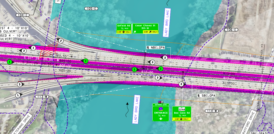
The MoPac South project involves expanding the highway bridge over Lady Bird Lake. The pink areas this the schematic represent areas where the crossing would be widened.
In Zilker Park alone, the environmental assessment says construction would require the temporary use of 3.84 acres in several locations. The work could require temporary overnight closures to the Butler Trail, the MoPac pedestrian bridge and the parking lot under MoPac, among other locations.
MoPac crosses the Edwards Aquifer recharge zone, the porous underground limestone where rainwater can move quickly underground to wells and Barton Springs. CTRMA says its contractor would take steps to avoid contaminating the water supply, but fears of accidental pollution have drawn scrutiny from environmental groups.
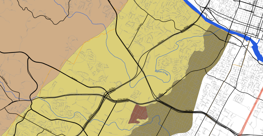
Barton Springs Edwards Aquifer Conservation District
MoPac travels through the middle of the environmentally sensitive Barton Springs Edwards Aquifer recharge zone — shown in yellow — where water filters through porous limestone and flows to Barton Springs.
For the first time, the environmental assessment lays out early plans for noise walls in specific locations. Five sound barriers are recommended. The largest would be 1.3 miles long and up to 20 feet high, and it would be installed next to Zilker Park.
A half-mile long noise barrier would be installed near the Legacy at Western Oaks apartments. A sound wall about 0.3 miles long would go in near Northland River Stone Ranch community. Noise walls more than 700 feet long are planned for MAA Barton Creek community and Sedona Springs Apartments.
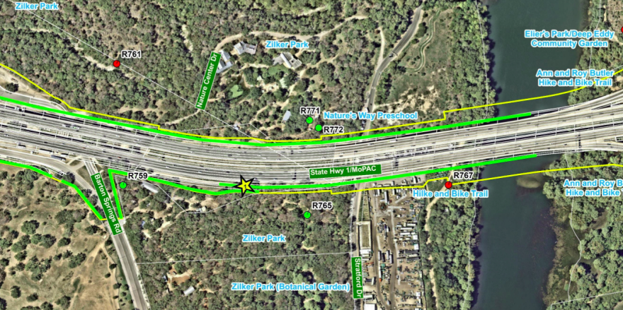
The largest noise wall for the MoPac South project would be installed next to Zilker Park, McBeth Recreation Center, the Butler Trail and Nature’s Way Preschool. The sound barrier would range in height from eight feet to 20 feet.
The project may also affect endangered species or critical habitat including the Austin blind salamander, Barton Springs salamander, Bee Creek cave harvestman, Tooth Cave spider, Golden-cheeked warbler, monarch butterfly, tricolored bat and bracted twistflower.
Fuel for critics
The details included in the report have revved up opponents of MoPac South who accuse CTRMA of downplaying harms caused by the project.
“They’re saying over and over, no significant impacts,” said Bill Bunch of Save Our Springs at a recent town hall organized by opponents of the project. “It’s simply not credible.”

Nathan Bernier
/
KUT News
Bill Bunch of the Save Our Springs Alliance speaking to a town hall opposed to the MoPac South project last week at Austin High School.
Those who have been concerned about the effects on traffic near Austin High School say the environmental assessment still doesn’t adequately account for how the project could funnel traffic onto Cesar Chavez near the school.
“It’s a chaotic traffic situation that has a lot of young drivers who we need to take care of,” Austin ISD Trustee Lynn Boswell told those gathered at the town hall. “We don’t have a good sense of what’s going to happen east to west.”
Travis County Commissioner Brigid Shea, another outspoken critic, said the project should undergo a rigorous environmental impact statement because of its effects on Barton Springs, water quality, endangered species and traffic.
“If you didn’t care about the environment, care about the traffic chaos this is going to create,” Shea told KUT News. “A full EIS requires them to look at the traffic impacts.”
Travis County commissioners approved a measure last week calling for a full EIS. They were joined a couple days later by Austin City Council.
After the May 3 public comment deadline, CTRMA will respond to each comment and prepare a final report.
TxDOT will ultimately decide if the project gets environmental clearance.
CTRMA previously told KUT News that design and construction of MoPac South could take about nine years.