
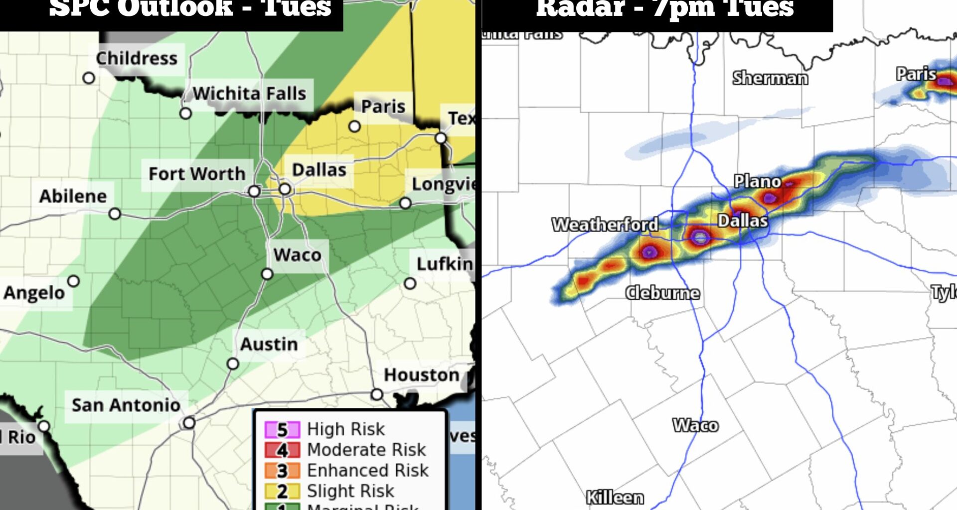
From left, the severe weather outlook in Texas on Tuesday from the National Weather Service’s Storm Prediction Center, along with the future weather radar model for 7 p.m. Tuesday.
Storm Prediction Center/Pivotal Weather
For much of Texas this spring, an active weather pattern has led to the constant threat of heavy rainfall and severe thunderstorms.
In San Antonio, 9.44 inches of rain have been recorded since April 1 — that’s the city’s highest rainfall total for that period in more than 60 years. Houston has picked up 9.02 inches over the same stretch, nearly double its climate-average. Dallas has seen less rainfall at 5.07 inches, but that’s still more than 20% above normal.
The active weather will continue across Texas over the next few days, as yet another cold front will slowly push through the state. The front will likely spark a few strong to severe storms in North Texas on Tuesday, before the severe weather threat shifts farther south on Wednesday. Scattered large hail will be possible for some.
Article continues below this ad
Tuesday severe weather
The incoming cold front will likely push across the Red River in far North Texas early Tuesday afternoon, eventually nearing the Dallas-Fort Worth metroplex by 4p.m. or 5 p.m. In the hours that follow, a few scattered strong thunderstorms are expected to develop across North Texas, especially between 5 and 9 p.m.
Dallas is under a level 2 of 5 risk of scattered severe thunderstorms Tuesday, along with areas to the northeast, such as Rockwall, Greenville and Texarkana. While severe weather is not expected to be widespread, this region will have the highest chance of seeing large hail and damaging winds. An isolated tornado is also possible.
The Storm Prediction Center’s outlook for Wednesday shows the severe weather threat in Texas will shift to the south.
Pivotal Weather
Wednesday storms shift south
The cold front will slide farther south on Wednesday, leading to a risk of storms developing across parts of Central, South and East Texas.
Article continues below this ad
The highest risk of storms will exist in East Texas, an area that includes Tyler, Lufkin and Huntsville, and stretches toward Waco. This is where a level 2 risk of severe weather is in place. Storms still likely won’t be widespread, but the scattered storms that do form may be capable of producing large hail and damaging winds.
Farther south and west, cities such as Austin, San Antonio and Houston are under a level 1 risk of severe weather. The lower risk means lower storm coverage expected over this region, so much of the area will stay dry.
San Antonio will have about a 20% chance of thunderstorms Wednesday afternoon and evening. However, if a storm is able to develop, it could strengthen quickly, become severe and be capable of dropping large hail.
Cooler air incoming
The cold front will slide through the San Antonio area overnight through Thursday morning, leading to cooler temperatures. Daytime temps are expected to reach only the lower to mid-70s on Thursday, which would be 12 to 15 degrees cooler than Wednesday’s expected peak temps.
Article continues below this ad
The front also will bring some atmospheric moisture into the area, with rain chances in San Antonio rising to around 40% by Thursday morning and afternoon. Although a few storms could be strong, widespread severe weather is not expected as the cooler air behind the front will help to stabilize the atmosphere.
The coolest temperatures will arrive Thursday night and into early Friday, as low temps across South Texas will sit in the upper 50s to low 60s. The cooler weather will be short-lived, however, as highs will rise back to the 80s on Friday and Saturday.