
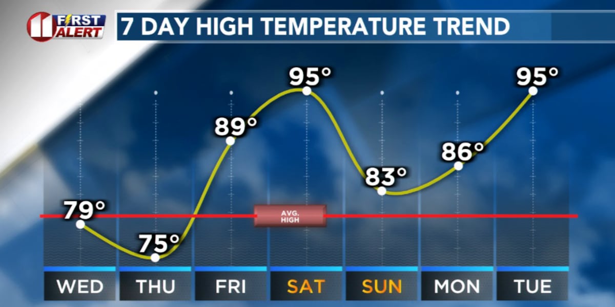
LUBBOCK, Texas (KCBD) – A cold front pushed through the South Plains early Tuesday, and while it brought some relief from the heat, the warmth and wind aren’t done with us just yet. Wednesday and Thursday will bring cooler temperatures, but by Friday the pattern quickly flips with warmth and wind returning.
Quiet Night
Tonight winds will be light (in speed) and variable (in direction) as the cold front settles across the region.
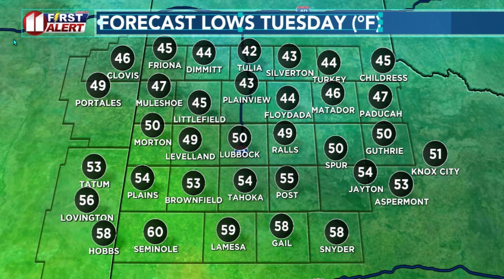 Quite a range in low temperatures tonight into early Wednesday.(KCBD First Alert)
Lows will drop into the 40s across the northern KCBD/FOX34 viewing area with upper 50s to low 60s across the southern viewing area. A low stratus cloud layer will develop over much of the area overnight.
Breezy and Cooler
Wednesday will bring a similar setup to what we’ve seen today. The clouds, however, are expected to finally clear out with a mostly sunny afternoon. Low pressure developing over northeastern New Mexico will gradually switch winds back to southwesterly and ramp up speeds to around 15 to 20 mph in the afternoon. Gusts around 30 mph will be possible.
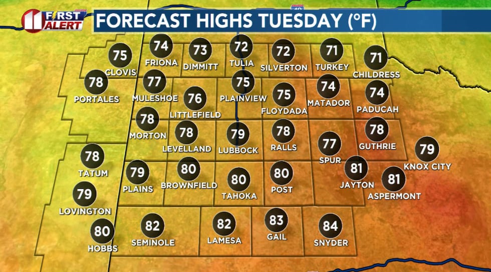 Temperatures will vary considerably Wednesday afternoon from north to south.(KCBD First Alert)
Though cooler than recent days, the wind and dry conditions will elevated the wildfire danger once again, especially along the New Mexico border. If you will be engaged in outdoor activities, be mindful of fire safety.
The Calmest Day
A light freeze or frost is possible early Thursday morning across the far northwestern KCBD/FOX34 viewing area, southwestern Texas Panhandle, where temperatures potentially may dip to near freezing. If you have sensitive plants or outdoor concerns, keep an eye on those early morning lows.
Thursday afternoon brings the best of the cooler pattern. Light winds are anticipated across the region, and highs will settle into the 70s. It’s the day to enjoy milder temperatures before the heat returns.
Wind Returns
By Friday afternoon the pattern will shift back to warmth and wind.
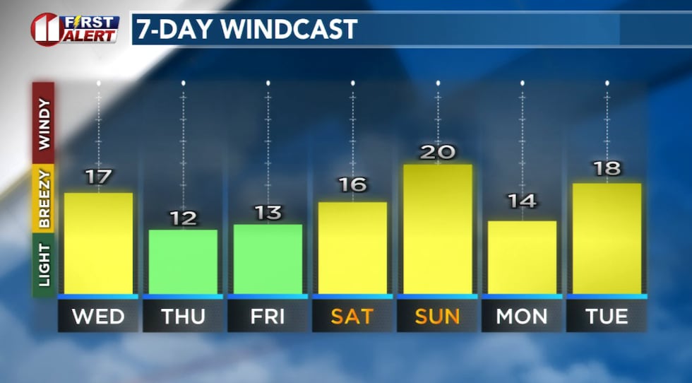 Forecast peak sustained winds are shown in this graph. Peak gusts will exceed the values shown here.(KCBD First Alert)
South to southwesterly winds will develop as another system moves through the Rockies, and temperatures will climb back into the 80s, perhaps 90s in the lower elevations of the eastern viewing area.
Heat Returns
Saturday afternoon will get hot — very hot. Some areas across the southern Rolling Plains, the southeastern KCBD/FOX34 viewing area, may see triple-digit highs.
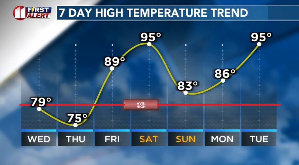 Briefly cooler Wednesday and Thursday.(KCBD First Alert)
Along with the heat comes wind. Saturday will be breezy to windy, and the combination of hot temperatures, strong winds, and dry conditions will create elevated to critical fire danger across the region. This is not a day for outdoor burning or anything that could spark a fire.
Mothers’ Day
A cold front is expected to push through overnight Saturday into early Sunday, bringing slightly cooler air for Sunday. We don’t expect a dramatic cool-down — with highs likely still in the 80s.
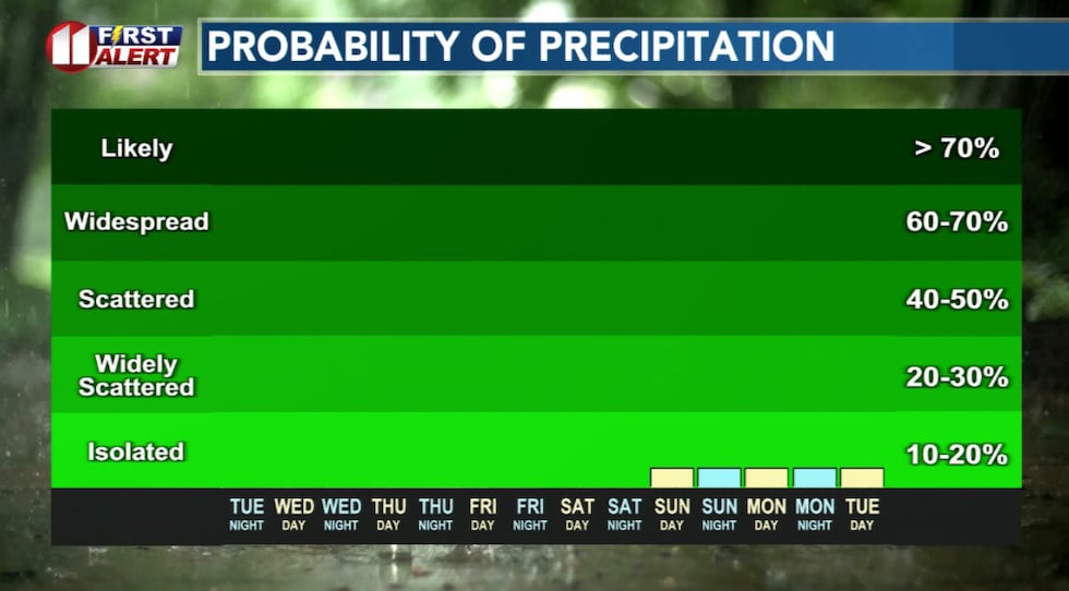 There is no significant signal for measurable rainfall into early next week.(KCBD First Alert)
There still is no sign of measurable rainfall in the forecast through early next week.
Stay with KCBD for possible updates, here on-line, or on-air or in the free KCBD weather app.
On This Date
On this date in 2002, a deadly outbreak of tornadoes occurred in the extreme southern Texas Panhandle. Over the course of 4.5 hours, at least nine tornadoes touched down from Castro County east to Childress County. The worst claimed two lives on the southeast side of Happy when a mobile home was rolled and destroyed. Four injuries also occurred in mobile homes that were in the same area.
In total, this F2 tornado destroyed fifteen homes, caused major damage to another seventeen, and minor damage to eighteen others. Thirty vehicles, including two tractor trailers, were damaged or destroyed. In addition to tornadoes, many of the supercells produced equally-destructive downburst winds as high as 100 mph. In Memphis a wind gusts up to 82 mph caused extensive damage to about 50 buildings and overturned four tractor trailers, snapped power poles and trees.
(Source: National Weather Service, Lubbock)
Copyright 2026 KCBD. All rights reserved.