
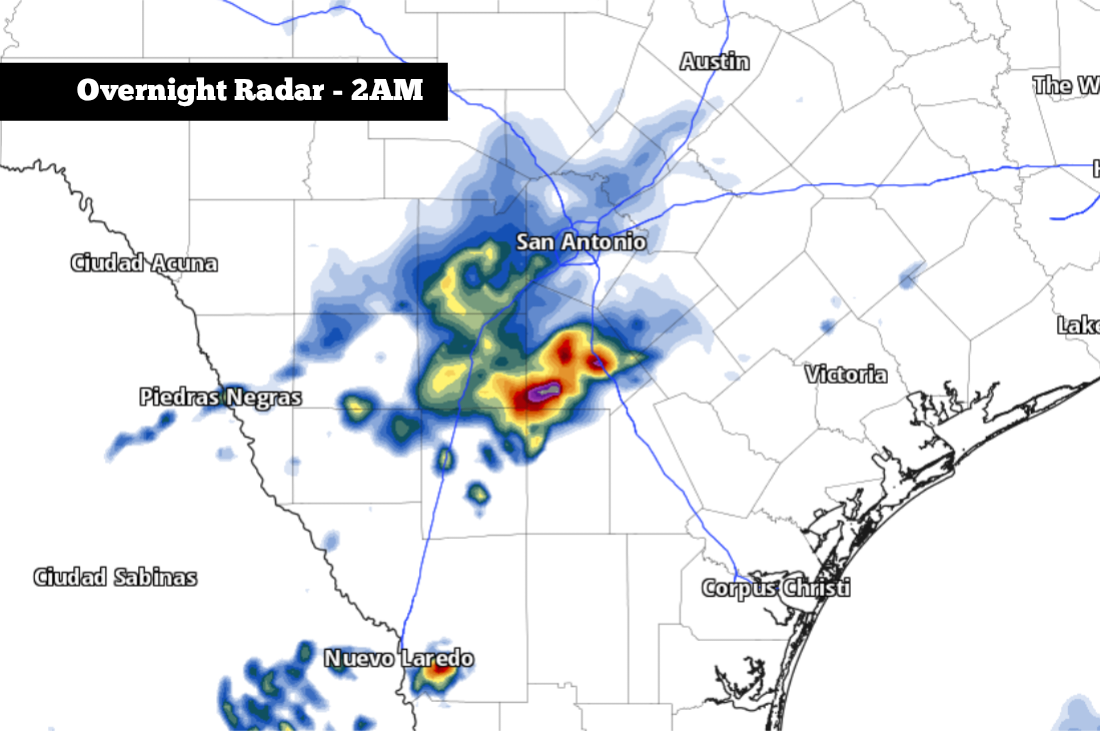
The potential weather radar model for 2 a.m. Saturday shows a cluster of showers and storms moving over South Texas.
Pivotal Weather
After a cool and relatively quiet Thursday across South Texas, more changes in the weather are coming Friday, courtesy of a low pressure system expected to sweep into Texas by the evening. Combined with rising levels of atmospheric moisture, this will create the opportunity for a few storms to develop across South and Central Texas, although rain is not expected to be widespread.

The vast majority of the day will remain dry, but this weather system will bring two opportunities for rain. First, light rain and drizzle will be possible early Friday. Then, after a quiet afternoon and evening, there’s potential for a few thunderstorms late Friday and into the overnight hours.
Article continues below this ad
Friday forecast timeline
Morning (4 a.m. to 10 a.m.): Cool and cloudy weather is expected early Friday, with temperatures likely to sit in the mid-60s through 10 a.m. Along with overcast skies, a few isolated light showers and patchy drizzle will be possible across the San Antonio metro area.
Rainfall, if any, won’t amount to much during this time, but it could result in some wet roadways during the morning commute.
Midday (10 a.m. to 5 p.m.): Mostly dry weather is expected through the middle of the day, although an isolated shower or weak storm remains possible. Overall rain chances during the afternoon will only be around 10% in San Antonio.
Article continues below this ad
Temperatures will slowly rise, likely reaching 70 degrees at noon before topping out in the upper 70s. Skies will stay mostly cloudy, but a few peeks at sunshine are possible, mainly after 3 p.m.
Evening (5 to 10 p.m.): Rain chances will stay low throughout the evening, with less than a 20% chance of an isolated shower or storm. Temperatures will also be comfortable, expected to hover in the low 70s.
Article continues below this ad
Late night/overnight (10 p.m. to 6 a.m.): This is when the higher rain chances will take shape, as a cluster of storms may develop near the Rio Grande late Friday and spread eastward toward San Antonio. However, recent model data suggests that chances will not rise as high as previously expected.
Overall storm chances for San Antonio will start to rise after 9 p.m. (20%), with the greatest chances (30%) expected after midnight. Because this activity is expected to stay scattered, many areas will stay dry. A few storms could be capable of producing hail and frequent lightning, but widespread severe weather is not expected.
Slightly higher storm chances are expected south and west of San Antonio, in areas like Eagle Pass, Pearsall and Pleasanton.
Saturday and Sunday
From left, the expected peak daytime temperatures across South Texas on Saturday and Sunday.
Pivotal Weather
The weekend is expected to bring much warmer weather into South Texas. Skies are expected to become mostly sunny by Saturday afternoon, allowing high temps to reach the mid- to upper 80s. A small chance of a few isolated storms remains during the afternoon, but most are expected to stay dry.
Article continues below this ad
Rain chances will stay very low on Mother’s Day — great news if you have any plans scheduled with Mom. However, you can expect especially warm weather on Sunday. Morning temperatures in the 70s will transition into the low 90s by the afternoon. The air will be humid, too, causing the “feels like” temp to rise into the mid-90s.
A cold front is likely to push into South Texas by around 10 p.m.Sunday night, bringing cooler temps, gusty winds, and a 20% chance of rain.