
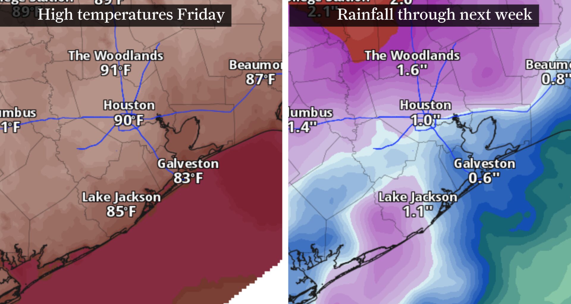
From left, a map of forecast high temperatures Friday in the Houston metro area, and forecast rainfall through the middle of next week. After a hot and dry week, slightly cooler and wetter weather returns next week.
Pivotal Weather
The spring heat dome baking Houston this week is finally expected to weaken by this weekend, setting the stage for a stormier weather pattern next week.
An upper-level atmospheric ridge of high pressure brought Southeast Texas some 90-degree days this week, with one more expected Friday. As southeasterly winds return, drawing in atmospheric moisture, humidity will surge back into the region and help fuel a potentially stormy start to next week.
Houston has one more day near 90
As a surface high pressure system moves east toward Florida, Friday weather should feature slightly better air quality and an increasingly humid feel.
Article continues below this ad
Surface winds around high pressure rotate clockwise, which means southerly to southeasterly winds will pick up in intensity. Gusts during the afternoon could reach 25 to 30 mph at times, far stronger than in recent days, when winds were generally below 5 mph.
HEAT TRACKER: Track Texas temperature swings using the Houston Chronicle’s interactive map.
Even as the high pressure shifts east, it will keep temperatures elevated across Southeast Texas. Afternoon temps are expected to peak around 90 degrees in Houston. Neighborhoods outside of the city’s urban heat island may stay just below 90 degrees, with the coolest weather confined to the immediate coast.
The biggest difference between Friday’s forecast is the increased cloudiness. A moisture-rich air mass will allow puffy fair-weather cumulus clouds to bubble up during the afternoon, which would be a big change from the mostly sunny skies earlier this week.
Article continues below this ad
Muggy and (mostly) dry weekend
If you’re checking the weather app on your phone, this weekend might appear cooler at first glance. Unfortunately, those numbers don’t tell the full story.
Yes, air temperatures this weekend may nudge below 90 degrees. But dew point temperatures are expected to climb into the 70s by Saturday afternoon.
Remember that dew points, or how cool the air has to get for dew to form, can indicate how saturated the air is with moisture. A dew point above 65 degrees typically means sticky, muggy air. Too much atmospheric moisture, or humidity, makes it harder for sweat to evaporate from your skin, which is how your body cools down.
That’s where the heat index comes in, providing a more accurate depiction of temperatures because it takes humidity into account. Those dew points this weekend in the 70s will push heat index values — or how hot it feels outside — into the 90- to 95-degree range by Sunday.
Article continues below this ad
Southeast Texas rain chances Sunday afternoon, as shown on this map, indicate that isolated to widely scattered storms could bubble up as humidity ticks higher.
NOAA’s National Weather Service
All of that extra moisture could lead to isolated storms each afternoon, although Sunday’s storm chance is slightly higher at around 20% compared to Saturday’s.
If you’re looking for more storms to water your lawn, a pattern change next week could bring you better luck.
Next week: Daily storm chances
A trough of low air pressure is expected to push into the western United States on Monday. This feature, which might sound far removed from Texas, will send ripples of atmospheric energy into the Lone Star State during the first half of next week.
Article continues below this ad
Increasing atmospheric moisture and rising air will enhance storm chances across Southeast Texas. Based on the most recent forecast trends, the highest rain chances likely arrive Tuesday into Wednesday, but scattered downpours are possible as early as Monday.
Although daily storms will be driven primarily by afternoon heating, a few overnight storms are still a possibility.
Some areas of Southeast Texas could pick up more than an inch of rain through the middle of next week. Rainfall totals will vary considerably from one neighborhood to the next.
Article continues below this ad