
People cool off in what’s commonly known as Barking Springs, just downstream of Barton Springs Pool, on a hot afternoon last year in mid-May. On Friday, temperatures will climb into the lower 90s during the afternoon.
Jay Janner/American-Statesman
Weekend warriors across Central Texas are in luck, as warm and mostly dry weather is expected to hold through Sunday, making it ideal for outdoor plans and events.

Morning clouds, afternoon sunshine, rising humidity, and breezy south winds will dominate the weekend weather, with afternoon temperatures climbing to around 90 degrees — which would be about five degrees above average for mid-May. Despite the warmer days ahead, May has been relatively mild so far. This month has had only a handful of 90-degree days compared to last year, when Austin had already recorded two days of triple-digit temperatures by mid-month.
Article continues below this ad
Through the first half of May, the average temperature has been 70.9 degrees, ranking this month among the 30 coolest Mays on record, dating back to 1898.
The coolest start to May occurred in 1917 with an average temperature of 63.8 degrees, while the warmest came in 2022 when the average temperature soared to 83.1 degrees.
What is the Friday forecast?
The large, dry air mass that has been in place over Texas this week will begin to weaken Friday, as strengthening south-southeast winds draw in more atmospheric moisture, leading to higher humidity to the region.
Article continues below this ad
Even with the added moisture, rain chances remain low because of a strong capping inversion — a layer of warmer air aloft that acts like a lid on the atmosphere, preventing clouds from rising high enough to produce rain. Underneath that cap, humidity-driven heat index values, or “feels like” temperatures, will continue to build each day heading into next week.
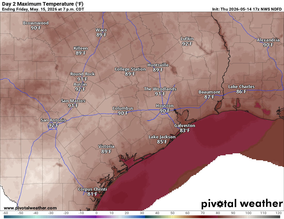
Daytime temperatures will climb into the lower 90s on Friday afternoon with humidity driving the “feels like” temperatures into the mid-90s.
Pivotal
Morning temperatures will start near 70 degrees before climbing into the low 90s during the afternoon. Heat index values should stay manageable, only running a degree or two warmer than the actual air temperature. Increasing afternoon wind gusts near 25 mph also should help keep the weather from feeling too sticky and uncomfortable.
Article continues below this ad
What is the weekend forecast?
Saturday’s weather will be a repeat of Friday’s with morning temperatures starting in the lower 70s before warming into the lower 90s. However, we’ll see a little more sunshine in the afternoon and the heat index values will creep up a bit, into the mid-90s.
By Sunday, the heat and humidity will become more uncomfortable with heat index readings climbing into the upper 90s to near 100 degrees, especially south and west of Austin. We’ll also see more clouds and gustier southerly winds of up to 30 mph.
Humidity-driven heat index readings will be much higher for areas south and west of Austin, mainly ranging from 98 to 103 degrees.
Pivotal
“Now those higher heat indices may come with a caveat,” meteorologists at the National Weather Service wrote in their daily forecast discussion on Thursday. “The capping inversion is expected to hold through the afternoon Sunday and for most areas Monday, but destabilizing conditions begin to warrant some low chance PoPS (probability of precipitation) for western counties Sunday night and expand into the rest of the forecast area by late Monday.”
Article continues below this ad
As storm chances return early next week, a few thunderstorms could become strong to severe and produce heavy rainfall.
Right now, the weather service’s Storm Prediction Center has higher concerns about severe weather focused across North Texas and the Panhandle on Sunday and Monday, with no organized severe weather risk outlined for Central Texas yet. However, with May being the heart of severe weather season, we’ll still need to keep a close eye on the potential for a few locally strong or severe thunderstorms during that time.