
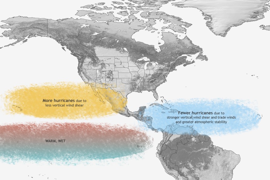
El Niño is expected to emerge in the next several weeks, much earlier than expected. Its effects on hurricane season can vary, depending on where tropical cyclones form.
Climate Prediction Center/National Oceanic and Atmospheric Administration
Earlier this year, El Niño wasn’t expected to arrive until the fall or early winter. However, recent forecast trends have significantly accelerated that timeline. According to the latest update from the National Weather Service, released Thursday, there is now an 82% chance that El Niño develops between May and July.
For El Niño to officially develop, sea-surface temperatures in the eastern equatorial Pacific Ocean must be at least 0.5 degree Celsius warmer than the long-term average. As of Thursday, temperatures in that region were already 0.4 degree above average, meaning that El Niño status could be reached within the next few weeks.
For El Niño to officially develop, sea-surface temperatures in the eastern equatorial Pacific Ocean must be at least 0.5 degree Celsius warmer than the long-term average. Forecasters are giving El Niño an 82% chance of forming between May and July.
Climate Prediction Center/National Oceanic and Atmospheric Administration
Forecasts show El Niño continuing to strengthen through the fall and winter months. The weather service’s outlook indicates a nearly 40% chance of a “very strong” El Niño, which would mean sea-surface temperatures rising to more than 2 degrees Celsius above average. That has happened only six times since 1950, with the most recent one occurring in 2024.
Article continues below this ad
Some forecast models — particularly the ECMWF global ensemble model — even suggest the incoming El Niño could become the strongest ever recorded.
Forecasts show El Niño continuing to strengthen through the fall and winter months. The weather service’s outlook indicates a nearly 40% chance of a “very strong” El Niño, which would mean sea-surface temperatures rising to more than 2 degrees Celsius above average.
Climate Prediction Center/National Oceanic and Atmospheric Administration
El Niño’s effect on hurricanes in the summer
When the tropical Pacific warms during El Niño, stronger winds high in the atmosphere over the Atlantic and Caribbean can disrupt developing storms, making it harder for hurricanes to organize and intensify.
Because of that effect from wind shear, El Niño events typically result in fewer Atlantic hurricanes than average. During strong El Niño events, hurricanes have rarely threatened the Texas Gulf Coast. Since 1850, only one storm — Hurricane Audrey in 1957 — came close, making landfall in far southwest Louisiana during a moderate El Niño.
Article continues below this ad
Last month, the hurricane season forecast from Colorado State University researchers, one of the nation’s most widely trusted and highly regarded hurricane season assessments, predicted slightly below-average activity in the 2026 Atlantic hurricane season, largely because of the developing El Niño.
WEATHER EXPLAINED: What a rare ‘Super El Niño’ could mean for Texas winter weather and the Atlantic hurricane season
Typically, El Niño has its biggest effect on Texas during the winter months, as the Pacific jet stream becomes stronger and shifts closer to Texas. This leads to more frequent cold fronts and a more active storm track across the southern United States, resulting in cooler and wetter weather across the Lone Star State.
But what about summer? Could an active El Niño also bring cooler temperatures and more rainfall during the hottest months of the year? We looked back at previous El Niño events to find out.
This chart shows periods when El Niño or La Niña events have occurred since 1950 through 2024.
Climate Prediction Center/NASA
Does El Niño affect summer weather?
Since 1950, the Northern Hemisphere has had 16 summers when El Niño was active.
Article continues below this ad
During those years, El Niño summers in Houston averaged about a half-degree warmer than normal, while rainfall was even more noticeably reduced, with 23% less rainfall observed during El Niño summers.
In San Antonio, the city’s average summertime high temperature was 94.9 degrees — about a half-degree warmer than in non-El Niño summers. Of those 16 El Niño summers analyzed, nine produced above-average temperatures, three were near-average, and four years resulted in below-average temps.
San Antonio also has averaged only 7.05 inches of rain during El Niño summers, which is 12.4% drier than non-El Niño summers.
While the differences in the temperature data are not dramatic, the numbers suggest that a summertime El Niño slightly favors warmer and drier weather in Houston and San Antonio. That’s the opposite of El Niño’s typical wintertime effects, which tend to bring cooler and wetter weather.
Article continues below this ad
However, the pattern is not consistent across the entire state. In Austin, the effects have been much less pronounced. Temperatures during El Niño summers have averaged just 0.3 degree warmer than normal, while rainfall totals have been nearly identical to the long-term average.
Across North and West Texas, historical data shows little difference in summertime weather during El Niño years. Both Dallas and Lubbock have seen almost no change in average temperatures or precipitation when El Niño is active.
Overall, the data suggests El Niño might have only a small effect on summer weather in Texas, especially across the southern half of the state, where conditions tend to be slightly warmer and drier than average. However, those effects are relatively minor compared to the much stronger influence El Niño typically has during the winter months.
Article continues below this ad
Newsroom meteorologist Justin Ballard contributed to this report.