
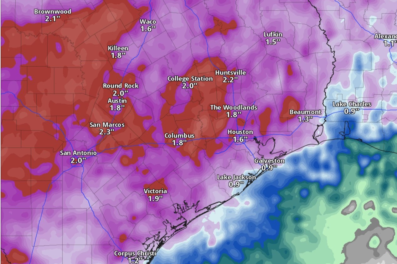
Cumulative rainfall amounts through Thursday night could exceed 2 inches across Texas, according to the National Blend of Models, a composite weather forecast model.
National Blend of Models/Pivotal Weather
Central Texas, including Austin, cities along the Interstate 35 corridor and parts of the nearby Hill Country, will be under an elevated risk of severe weather starting Tuesday night and lasting into the rest of the work week. The repeated occurrence of thunderstorms could lead to heavy rainfall and localized flooding across the region.

Here’s the likeliest storm timeline, based on the latest forecasts from the National Weather Service.
Article continues below this ad
Tuesday
Afternoon: Although Tuesday is starting out sunny in Austin with clear skies, we can expect rain chances to start creeping higher after 10 a.m. Temperatures should climb as high as 91 degrees, which would be slightly higher than normal for May 19. However, the humidity-driven heat index values could make the heat feel more like it’s 101 degrees, forecasters said.
Thanks to south-southeast winds of around 10 mph, including gusts as strong as 20 mph, bringing in more atmospheric moisture, rain chances will be as high as 40%.
“Dry conditions are likely through late this afternoon before a weak cold front slowly moves towards our area, evident by likely ongoing convection (storm development) north of our area in the afternoon,” the weather service said in a forecast bulletin Tuesday morning. “Further west, isolated to scattered storms may develop near the dry line over the higher terrain of Mexico, then make its way wast towards the Rio Grande before colliding with the front.”
Article continues below this ad
The Storm Prediction Center has placed an area along and west of the I-35 corridor under a level 2 of 5 risk of scattered severe thunderstorms capable of producing large hail, damaging winds and possibly a brief tornado.
Storm Prediction Center/National Weather Service
Night: With rain chances ramping up to 80%, we can expect showers or thunderstorms in Austin before 10 p.m., then more rain into the overnight hours.
“Scattered to widespread showers and thunderstorms will be nearing the Hill Country from the north or northwest in the evening then move across the area tonight into Wednesday morning,” the weather service said.
Article continues below this ad
The weather service’s Storm Prediction Center has placed an area along and west of the I-35 corridor under a level 2 of 5 risk of scattered severe thunderstorms capable of producing large hail, damaging winds and possibly a brief tornado.
“While there could be some isolated storms ahead of the front and in the west ahead of the dry line, the main activity will likely be in a line or broken line as it enters our area this evening,” forecasters said. “The main severe risk continues to be isolated strong to severe wind gusts, though potentially large hail cannot be ruled out with the strongest updrafts.”
Meanwhile, the weather service’s flood forecasters at the Weather Prediction Center have placed most of South and Central Texas under a level 2 of 4 risk, or at least a 15% chance, of excessive rainfall that could lead to flash flooding.
Overnight: Temperatures from overnight into early Wednesday will bottom out around 73 degrees. After midnight, the balmy southeast winds of 5 to 10 mph will become northeast breezes.
Article continues below this ad
Austin, the I-35 corridor could receive at least 0.75 inch to a full inch of cumulative rainfall through Wednesday morning, but pockets of locally higher amounts could range from 3 to 5 inches, forecasters said.
Wednesday
Morning: “Most storm activity will be south of our area near sunrise with more stable conditions in place as the atmosphere recovers,” the weather service said. “Cooler temperatures in the 80s are expected for a majority of the area Wednesday.”
Afternoon: Austin on Wednesday will have only a 30% chance of rain, mainly after 10 a.m., under partly sunny skies. Daytime temperatures will stay solidly in the 80s, peaking at 85, which would be closer to the climate-average.
Article continues below this ad
Night: Rain chances in Austin rebound to 80% Wednesday night, thanks in part to the return of east-southeast winds carrying atmospheric moisture from the Gulf Coast into Central Texas.
“The atmosphere may still be recovering for most areas Wednesday evening but a highly moist air mass and stalled (front or) surface boundary to the north will allow for continued medium to high rain chances Wednesday night and Thursday,” the weather service said. “Some (forecast model) guidance indicates a complex of storms developing in West Texas and moving towards the area late Wednesday night and gradually working its way across the area Thursday.”
Overnight: Temperatures overnight into Thursday morning will stay above a comfortable 72 degrees.
Thursday
Austin on Thursday will have another day with an 80% chance of rain or thunderstorms. Rain-cooled air will help keep daytime temperatures capped at 83 degrees, which would be slightly cooler than normal for May 21.
Article continues below this ad
“There is some potential for severe weather but higher confidence would be for some heavy rain given high precipitable water values,” the weather service said. Precipitable water values are a measure of how much liquid water could be extracted from a column of air rich with water vapor.
Portions of the Hill Country, the I-35 corridor and the Coastal Plains will continue to be under a level 2 of 4 risk, or at least a 15% chance, of flood-producing excessive rainfall on Thursday.
“Each round of rainfall will lead to a deeper moistening of soils and possibly more runoff late week as grounds saturate,” the weather service said. “The pattern may lead to widespread beneficial rain for most areas, but areas that receive repeated rounds and higher totals will likely see increasing potential for flash flooding or river flooding.”
Article continues below this ad