
At the edge of the Ship Channel in Pasadena, children playing at a 122-unit housing complex have a front-row view of a forest of industrial facilities — tank farms, a chemical processor, a gas manufacturer, a fertilizer-maker — that federal officials have tentatively moved to higher-risk flood zones.
“It’s very risky to live here in this area,” said Esmeralda Sifuentes, who moved to the building recently but has lived in Pasadena for years. Chatting in Spanish at the end of a long workday, she said she appreciates the convenience and quiet community where she lives, but worries about her family’s exposure to pollution from industrial neighbors.
“It’s difficult to sleep. Anything can happen. It could flood, something could explode,” she said.
Sifuentes knew to be wary of flooding but was unaware that the Federal Emergency Management Agency had released drafts of updated flood maps for Harris County this spring, factoring in new data for a more realistic look at the risks communities face. The plants she can see from her home would move into the 100-year floodplain or even the floodway, FEMA’s highest-risk designation, if the draft maps take effect.
A Houston Chronicle analysis of flood maps and property records shows that 455 industrial facilities across Harris County could face a heightened flood-risk designation under FEMA’s proposal. While some of the facilities don’t handle hazardous substances, others are federally regulated facilities on the EPA’s Toxic Release Inventory list or are permitted to store chemicals.
Storage tanks on a Chevron property can be seen across from single-family homes along Red Bluff Road in Pasadena, Monday, May 18, 2026. The Chevron property would be in a higher flood risk zone under the new FEMA draft maps. Brett Coomer/Houston Chronicle
Such facilities have been the subject of numerous research efforts over the past decade that have shown how the danger of chemical contamination increases with sea level rise and extreme weather events.
“Harris County is No. 1 in the nation in terms of counts of the number of active, toxic industrial facilities that are at elevated flood risk,” said Jim Elliott, a Rice University scholar.
Elliott has researched the “toxic gumbo” that emerges when floodwaters sweep through petrochemical infrastructure and into communities. His work has examined flood projections beyond the FEMA maps, which he said tend to lag behind other risk data.
“Even with these expanded maps, they’re still just capturing the tip of the iceberg,” he said.
Higher risk for 455 industrial sites
FEMA’s newly released draft maps show a striking shift since the last flood zones were established in 2007. If the maps take effect, nearly half a million properties would fall into higher-risk flood areas than previously established, which would directly raise insurance costs for homeowners with federally backed mortgages when the maps are completed in the next few years.
Many homeowners also find themselves sharing a newly identified flood-prone area with industrial neighbors, from warehouses to chemical processors, including many along the Ship Channel.
“This change does not fundamentally affect how our members prepare for or respond to extreme weather, but it is likely to result in additional flood-hardening improvements at affected sites,” said MaryJane Mudd, executive director of the East Harris County Manufacturers Association.
She added that once completed, the FEMA maps “can affect factors like insurance requirements, future construction standards and how facilities evaluate flood risk.”
Under the proposed flood maps, 31 industrial properties would move, at least in part, into the floodway. An additional 245 properties would move into the 100-year floodplain — the area thought to have a 1% chance of flooding each year. And 158 would overlap for the first time with the 500-year floodplain.
Other industrial properties that already straddle several flood zones in the current maps would move farther into the riskier zones — the 100-year floodplain and floodway — if the draft maps take effect.
Federal regulations offer specific guidance for waste stored in special flood hazard areas, stipulating that “a facility located in a 100-year floodplain must be designed, constructed, operated, and maintained to prevent washout of any hazardous waste by a 100-year flood.”
The federal Environmental Protection Agency also requires industrial sites holding large amounts of chemicals to have up-to-date emergency plans.
These “must address flood‑related release scenarios, coordination with local responders at least annually, public notification, and periodic exercises that can include flooding,” said Joe Robledo, a regional EPA spokesman.
Robledo said that new FEMA maps would, in some cases, oblige companies to update their plans.
Industrial plants are seen near the Camino del Sol apartments in Pasadena, Monday, May 18, 2026. Residents and companies would move to a higher risk zone under the new draft maps. Brett Coomer/Houston Chronicle
In the Ship Channel, many facilities are strategically grouped for easy access to water and transport. With no zoning in the area, homes cluster at their fencelines.
Of the large companies with active facilities near Sifuentes’ apartment complex, many — including PCI Nitrogen, Air Products, Sekisui and Patriot Industries — did not respond to questions about what they would change if the proposed flood maps go into effect.
Chevron, which owns a cluster of massive storage tanks down Red Bluff Road, did offer comment, though the company did not say whether their property could face new regulations due to the flood-map update.
“Protecting people, property, communities and the environment are our top priorities,” said Chevron spokesman James Craig.
“The company has a robust risk-management process that considers both existing and potential risks, including floods. This process includes the development of contingency plans if needed.”
Toxic exposure for communities
Kristen Schlemmer, the legal director of local nonprofit Bayou City Waterkeeper, said research shows that contamination during minor flooding and excess chemical discharge are a common problem for the Houston region.
“When storms happen, it’s even worse, and often companies get a pass. We saw this during Harvey,” Schlemmer said. “Often these storms don’t trigger penalties, they’re considered acts of God. Which is really troubling, because it removes the incentive to do something about it.”
Even in emergency scenarios, facilities are required to report excess chemicals they release into the water or air to the Texas Commission on Environmental Quality. Some, like those handling wastewater, also need to plan for floods during state permit applications or renewals.
Wastewater treatment units and disposal sites “must be protected from inundation from a 100-year frequency flood event,” said TCEQ spokeswoman Laura Lopez. She said solid waste sites also face stricter requirements once they are in FEMA’s 100-year floodplain, which would kick in during permit applications, renewals or major changes.
Industrial plants are seen behind Red Bluff Road near a neighborhood of single-family homes in Pasadena, Monday, May 18, 2026. Residents and companies would be in a higher risk zone under the new FEMA draft maps. Brett Coomer/Houston Chronicle
Individual companies share their state and federal plans for chemical emergencies with a patchwork of local emergency planning committees, or LEPCs.
“They’re going to have a plan for how they would deal with, for example, floodwaters that jeopardize a large chemical tank,” said Brian Murray, Harris County’s deputy emergency management coordinator. He said the county has no authority to create regulations in this arena beyond the state and federal rules.
“Everything that happens relies on the response plans that those companies have,” Murray said.
Jackie Medcalf, who grew up along the ship channel and now runs the Texas Health and Environment Alliance, worried that messages on chemical risk and preparedness did not always reach communities. She remembered a mother who lives near a toxic waste site calling her after Hurricane Harvey.
“She said, ‘Jackie, my kids and my grandkids are here helping us clean out our house from the flooding. We’ve got all this mud in our house. Is it safe?’” Medcalf remembered telling her that anything touched by floodwaters could be carrying industrial toxins, and to “assume that it is contaminated.”
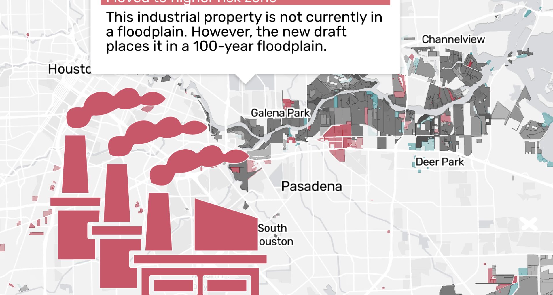
Increased flood risk in Pasadena
FEMA’s draft maps highlight a large cluster of industrial properties that could soon be moved into the floodplain
Map: Caroline Ghisolfi/Houston Chronicle • Source: Federal Emergency Management Agency; Harris Central Appraisal District.
Many residents living next to Pasadena’s new risk zone are clear-eyed about the water that regularly fills their streets.
Eddie Randall lives in the same area as Sifuentes and has pit bull mix puppies, two of the many pet dogs who play in the grass to the side of the complex. But when it starts to flood, he keeps them away from standing water.
“It’s dangerous for them because they think it’s the same as the water from their bowl, and they can get sick. The water’s got all kinds of things, it can have chemicals,” he said.
Pat Gonzales lives further from the plants now, following years of asthma and other health issues. She started the local group Caring for Pasadena Communities five years ago to address what she says is a lack of clear information available to community members about the risks they face.
Often, news of a leak or spill during a flood surfaces long after people could be exposed. She said many community members are unaware that the draft FEMA maps put more of the ship channel in the floodplain.
“I wish they would put that out in the community so they can be aware of any contamination that might happen,” she said. “People should have the right to know.”
About the data in this story
The Houston Chronicle sourced floodplain data from the Federal Emergency Management Agency. Floodplains appear in the data as a series of zones with different risk designations in the event of a flood.
Harris County has not had a comprehensive flood map overhaul since 2007. Although FEMA has made small, incremental updates to the maps since then (the data used in this story is based on a study conducted in November 2019 and was last revised in January 2026), the current maps rely on rainfall data that is two decades out of date.
Years in the making, the latest draft maps use higher rainfall estimates and more advanced modeling techniques, significantly expanding flood zone boundaries. The draft flood maps shown on this page were provided by FEMA to local communities for a review period. These maps are early in the development process and will be refined further before being published as preliminary maps.
Assigning risk to properties
The Chronicle overlaid the current and draft flood maps, and parcel boundaries sourced from the Harris Central Appraisal District to measure the effect of the new maps on the risk faced by properties across the county.
A property was considered affected if any part of its parcel boundary intersected a flood zone in either the current or draft maps. Properties were then categorized based on how their risk designations changed from one map to another.
For properties that span multiple flood zones – say, for example, a property that sits across a 100-year floodplain and a 500-year floodplain – we calculated a combined exposure score for each map and compared the two.
You can see the full list of current and draft flood zones affecting any property by clicking on it in the map.
 A morning newsletter that keeps you connected to Houston in 5 minutes or less.