
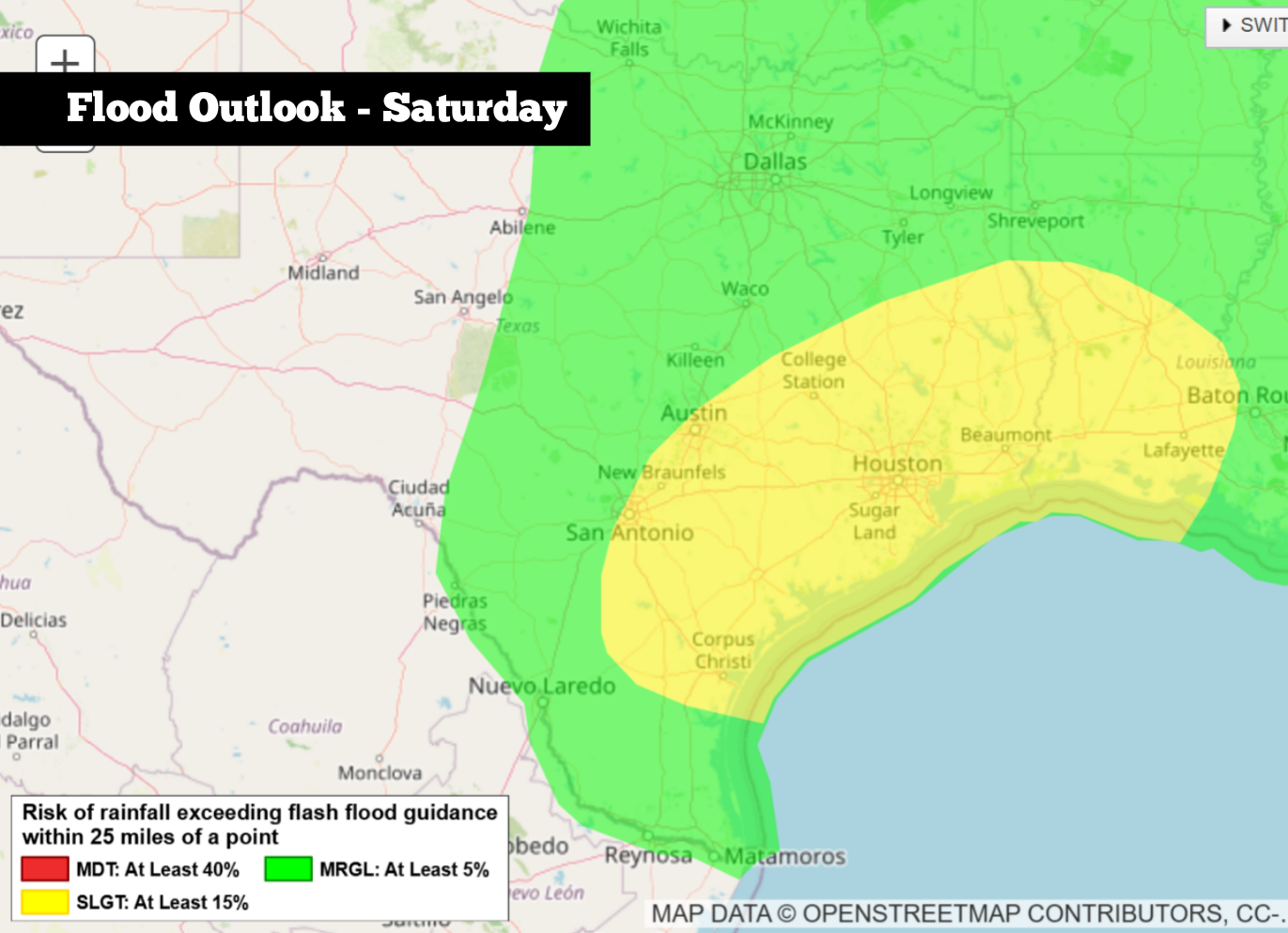
Shown is the excessive rainfall outlook across Texas on Saturday, which shows a level 2 of 4 risk, or at least a 15% chance, of flooding for San Antonio, Austin, Houston and Beaumont.
National Weather Service
Widespread rainfall has already fallen across much of Texas this week, and the weather pattern is expected to remain active through the Memorial Day weekend. A low pressure system in northern Mexico, combined with especially high atmospheric moisture levels, will result in several more rounds of rain over the next few days.

If you have outdoor plans, don’t panic just yet. This storm system is unlikely to produce widespread, all-day rainfall. Instead, the pattern will likely feature long, dry stretches interrupted by shorter periods of heavy rainfall and thunderstorms.
Article continues below this ad
However, because the ground is already saturated across much of South-Central and East Texas, more heavy rainfall could still lead to scattered flash flooding. Some weekend plans might still be good to go, but with a flood threat in place, it will be important to stay updated with the latest forecasts at expressnews.com/weather.
Weekend flood threat
Expect a lull in the storms for a large part of Friday, as rain chances will only be around 20% to 30% across South Texas. However, storm chances increase significantly overnight and into Saturday morning, with off-and-on rainfall possible into the afternoon and evening.
The highest rain chances on Saturday will be focused across the southern half of the state, including cities like San Antonio, Austin, Corpus Christi, Victoria, Houston and Beaumont. This large region — stretching from the Interstate 35 corridor east to the Texas-Louisiana border — is under a level 2 of 4 risk for excessive rainfall, according to the Weather Prediction Center, which provides flood forecasts for the National Weather Service.
Article continues below this ad
What does that mean, exactly? If you’re under a level 2 of 4 risk of flash flooding, that means there is at least a 15% chance of flash flooding within 25 miles of your given location. While it’s difficult to pinpoint exactly where flooding will develop, residents across this region are under an elevated flood threat.
Another round of downpours is possible from overnight Saturday into early Sunday morning. However, the heaviest rainfall is expected to shift farther east. Houston, Beaumont and Lufkin will remain under a level 2 of 4 flash flood risk on Sunday, but San Antonio and Austin will be downgraded to a minimal level 1 threat. Overall rain chances in San Antonio will drop to around 50%.
Potential rainfall totals across Texas through Monday could range from 3 to 5 inches, according to the National Blend of Models, a composite weather forecast model.
Pivotal Weather
Memorial Day outlook
As rain chances continue shifting east on Monday, the flood threat across South and Central Texas will diminish. San Antonio is expected to have only a 20% to 30% chance of more rainfall on Memorial Day.
Article continues below this ad
Outside of the slight storm chance, the weather is shaping up to be fairly pleasant in San Antonio for the holiday. Morning temps in the upper 60s to lower 70s will transition into afternoon temps in the mid-80s under partly cloudy skies. Humidity, however, could push heat index values, or “feels like” temps, closer to 90 degrees.
Higher rain chances are expected to persist across East Texas, with a 40% to 50% chance of more storms in cities such as Houston, Beaumont, Lufkin and Texarkana. A small flooding risk could accompany some of those storms.
Long-range models indicate that another round or two of thunderstorms will be possible between Tuesday and Thursday of next week. After that, drier weather might finally return to South Texas.
Article continues below this ad