
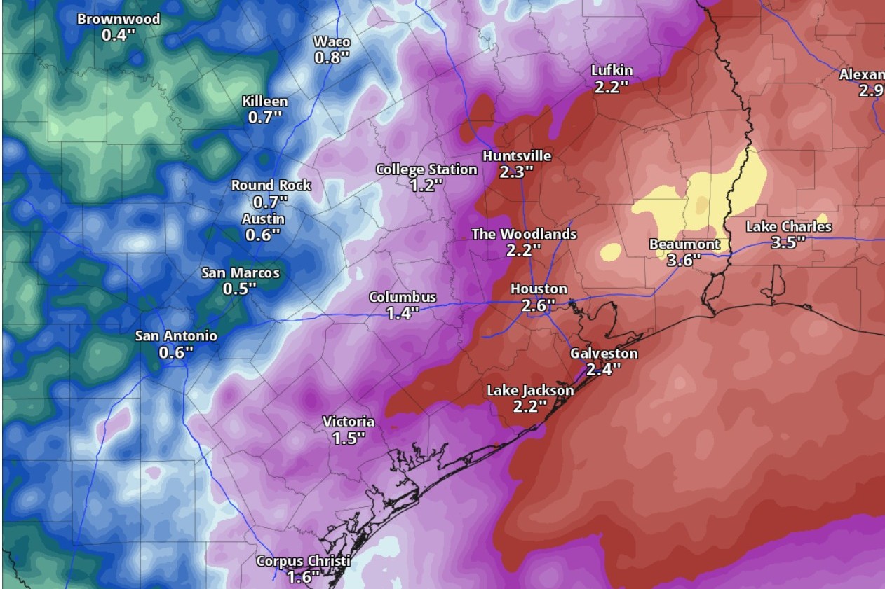
Through Monday night, the highest cumulative rainfall totals will be east of the Interstate 35 corridor, according to the National Blend of Models, a composite weather forecast model.
National Blend of Models/Pivotal Weather
The flood watch for Central and South Texas — including the Austin and San Antonio metro areas along the Interstate 35 corridor and the Hill Country — remains in effect through Monday night, the National Weather Service said. Forecasters are concerned about thunderstorms rolling through the regions over the Memorial Day weekend, and leaving rainfall amounts of up to 2 to 4 inches in their wake.

Here’s the rain timeline, based on the most recent weather service forecasts:
Article continues below this ad
Saturday
Morning-afternoon: Austin has an 80% chance of rain, which means most of us in the metro area will get wet. Austin’s best chances for showers and possibly storms will be after 1 p.m., as afternoon daytime heating occurs and the warm, vapor-saturated air rises to form storm clouds. Temperatures are expected to reach 84 degrees, which would be lower than on previous days, thanks to the resulting rain cooling the air.
Forecasters think Austin could see new rainfall totals of a tenth to a quarter of an inch, with higher amounts possible from stronger storms.
The flood watch for Central and South Texas, including the Austin and San Antonio metro areas along the Interstate 35 corridor and the Hill Country, remains in effect through Monday night, the National Weather Service said.
National Weather Service
Evening-overnight: Although Austin’s rain chances will ease to 60%, the showers or even storms are most likely to occur throughout the night under overcast skies. Meanwhile, temperatures will bottom out around 69 degrees before sunrise Sunday.
Article continues below this ad
“The elevated rain chances are even higher and broader in coverage into daytime Saturday,” the weather service said in a forecast bulletin Friday. “Given the fairly progressive eastward motions of this activity and the flow aloft, it’s probable that most areas will only see enhanced chances in one of the Saturday or Saturday night periods.”
Forecasters expect some parts of Central and South Texas east of I-35 to accumulate as much as an inch of rain throughout all of Saturday, with some isolated spots recording 3 to 4 inches.
Sunday
Morning-afternoon: The weather service is scaling back rain chances on Sunday, giving Austin only a 50% chance, but beginning as early as 7 a.m. Otherwise we can expect mostly sunny skies, with temperatures again peaking at 84 degrees.
Article continues below this ad
Evening-overnight: Skies over Austin turn partly cloudy at night, but overnight temperatures will stay above a balmy 70 degrees.
“If Saturday morning overachieves with the (storm) activity that begins late Friday night, then Saturday night and Sunday could be a brief recover period with a downward (probability of precipitation) trend by the time we get there,” the weather service said. “But the pattern is still unstable and could be also be shifted later on timing.”
Monday
Morning-afternoon: Memorial Day in Austin is shaping up to be relatively rain-free, with only a measly 20% chance of afternoon rain. You might be able to enjoy cooking out of taking a swim for the holiday under mostly sunny skies, as temperatures rebound to a high of 86.
Article continues below this ad
Evening-overnight: Skies stay mostly clear at night but temperatures stay largely in the 70s.
The week ahead
“Our unsettled weather pattern remains in place through at least next Thursday and potentially into next weekend,” the weather service said.
Article continues below this ad
Austin’s rain chances on Tuesday stay manageable at 30%, with showers again most likely after 1 p.m. under otherwise mostly sunny skies. Peak daytime temperatures start approaching 90 degrees, with a possible high of 88.
But the return of south-southeast winds in the afternoon mean an increase in atmospheric moisture — and that also means higher rain chances at night. Austin will have a 60% chance of rain Tuesday night into early Wednesday.