
Memorial Day is shaping up to be a good day to spend outdoors across South and Central Texas. While there’s a small threat of scattered storms by the afternoon, most of the day will be completely dry, which is perfect if you plan on grilling outdoors or spending time out by the pool.
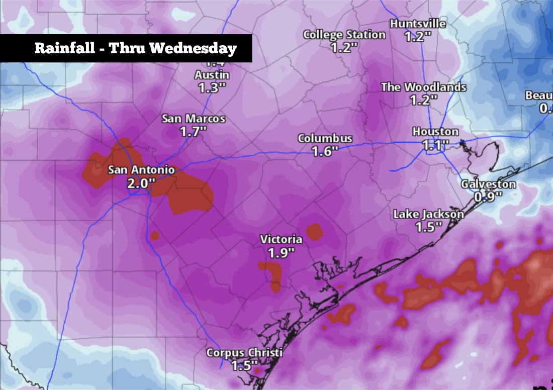
However, South Texas has been locked into an active weather pattern for the past week, and it’s not done quite yet. Yet another round of strong thunderstorms is expected by late Tuesday and into Wednesday, and it could bring heavy rain and potential flooding back into the region. Here’s the latest.
A beautiful morning is expected Monday in San Antonio, as morning low temperatures hover in the upper 60s to low 70s under partly to mostly clear skies. Temps will warm quickly throughout the day, reaching 80 degrees as early as 11 a.m. before topping out in the upper 80s by the late afternoon under mostly sunny skies.
Humidity levels will be slightly elevated, but atmospheric moisture levels will not be as high as they were last week. Expect the “feels-like” temperature to be just a couple degrees warmer than the actual air temperature, settling into the low 90s.
A few isolated showers or weak storms may develop by the late afternoon and evening. However, rain chances will be only about 10% to 20%, so most areas across South Texas will stay dry. A pleasant night is expected, as San Antonio temperatures will fall back into the 70s after 9 p.m.
On Tuesday, a low-pressure system in the western U.S. will strengthen and move closer to Texas, which will bring the energy necessary for widely scattered showers and thunderstorms.
For most of the day on Tuesday, San Antonio will stay dry, as high temperatures top out in the mid- to upper 80s under partly cloudy skies. Rain chances, though, will move into the region by the evening. San Antonio will have a 30% chance of scattered storms between 4 and 9 p.m., with chances rising significantly – to around 80% – during the overnight hours and into early Wednesday.
A few storms could produce damaging wind gusts, as well as isolated large hail. The largest threat is likely to be heavy rain and potential flooding. The National Weather Service has placed San Antonio and the Hill Country in a level 2 of 4 risk of flash flooding during this time.
According to the National Blend of Models, between 1.5 and 2 inches of rain is likely late Tuesday and into Wednesday. Isolated higher amounts of up to 4 inches will also be possible.
A few lingering showers and storms may be possible Wednesday afternoon. But by Thursday and Friday, much drier conditions are expected as rain chances will fall to less than 20%. Instead, high temperatures will rise back into the upper 80s to low 90s, under partly cloudy skies.
Long-range weather models do suggest that thunderstorm chances may return to the region next weekend and into early next week. Be sure to stay with expressnews.com/weather for daily forecast updates as we soon move into meteorological summer.