
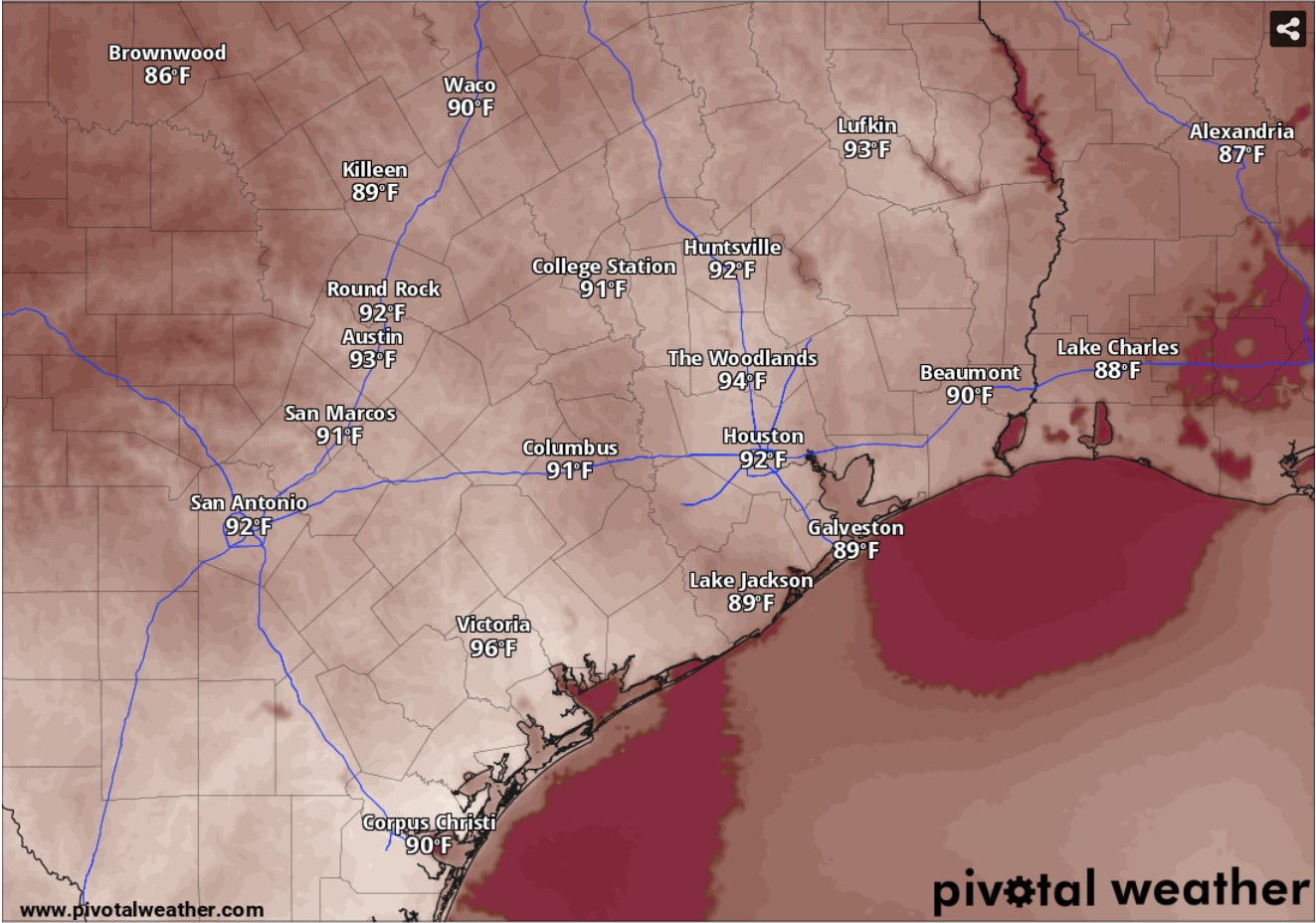
Humidity will drive up heat index values across Texas, including those in Houston, where highs in the upper 80s will feel several degrees warmer by 3 p.m. Thursday, according to the National Blend of Models.
National Blend of Models/Pivotal Weather
Thursday in Houston kicks off a stretch of drier, less active weather in Southeast Texas, at least until early next week, according to the National Weather Service.
Houston has only a 30% chance of afternoon rain on Thursday under otherwise partly sunny skies, forecasters said. Temperatures might start in the lower 70s at sunrise, but they’ll climb steadily and approach 90 degrees, likely peaking at 87.
More clouds will roll in Thursday night, which will help keep overnight temps above 74 degrees before dawn Friday.
Article continues below this ad
Dew point temperatures, particularly when they are above 65 degrees, can indicate uncomfortably muggy air. Dew points in Houston will be solidly in the 70s for the next several days, so brace for sticky weather through the weekend and into next week.
Recovering from Wednesday
Wednesday’s thunderstorms produced high winds, heavy rainfall, thousands of lightning strikes and resulted in widespread power outages.
CenterPoint’s outage tracker showed 20,000 reported power outages as of 7:30 a.m. Wednesday across the Greenspoint, Rosenberg and the South Houston areas, according to the utility’s outage map.
Article continues below this ad
STORM COVERAGE: 6,000 lightning strikes, strong winds leave thousands without power in Houston
Thursday is likely to offer welcome relief from the wet weather.
“Following the departure of (Wednesday’s) system, the region looks to get a break from active MCS (mesoscale convective system) patterns,” the weather service said in a forecast bulletin Wednesday. Mesoscale convective systems are essentially complexes of thunderstorms that organize on a scale larger than individual storm cells, and normally persist for several hours or more.
The six- to 10-day temperature outlook from the National Weather Service’s Climate Prediction Center has high confidence that temperatures across Texas will be cooler than normal in the first week of June.
Climate Prediction Center/National Weather Service
Dry weekend emerging
Forecasters said they anticipated “a subtle mid- to upper-level ridge” of high atmospheric pressure to build over Southeast Texas through the weekend.
Article continues below this ad
Houston on Friday should be mostly sunny, with light southerly winds adding breeziness to 90-degree afternoon temperatures. At night, expect more cloudiness and temps to bottom out only around 75 degrees into early Saturday.
“While this ridge (of high pressure) won’t be strong enough to completely suppress convection, any (storm) development should remain isolated to scattered and largely driven by daytime heating and any surface boundaries (e.g. sea breezes),” the weather service said.
As we close out May and prepare to enter June, the first month of meteorological summer, forecasters said we can “expect near-seasonal high temperatures to close out the workweek and persist into early next week.”
Houston on Saturday will likely have partly sunny skies with temperatures breaking into the lower 90s, possibly hitting 91 degrees. Mostly cloudy skies at night will help temps stay above a balmy 75.
Article continues below this ad
The six- to 10-day rainfall outlook from the National Weather Service’s Climate Prediction Center has high confidence that rainfall amounts across Texas will be higher than normal in the first week of June.
Climate Prediction Center/National Weather Service
Rain chances return
Rain chances start to creep back into the forecast on Sunday, when Houston has a slight 30% chance of afternoon rain. After sunset, rain chances edge higher to 40% as more clouds roll in.
For the first day of June, Monday’s weather in Houston will bring a 50% chance of rain, the highest chances for showers and thunderstorms in this forecast. Under partly sunny skies, clouds could keep temperatures below 89 degrees.
Article continues below this ad
The six- to 10-day temperature outlook from the National Weather Service’s Climate Prediction Center has high confidence that temperatures across Texas will be cooler than normal in the first week of June. That’s likely connected to the fact that the six- to 10-day rainfall outlook from the CPC also has high confidence that rainfall amounts across Texas will be higher than normal during the same period.