
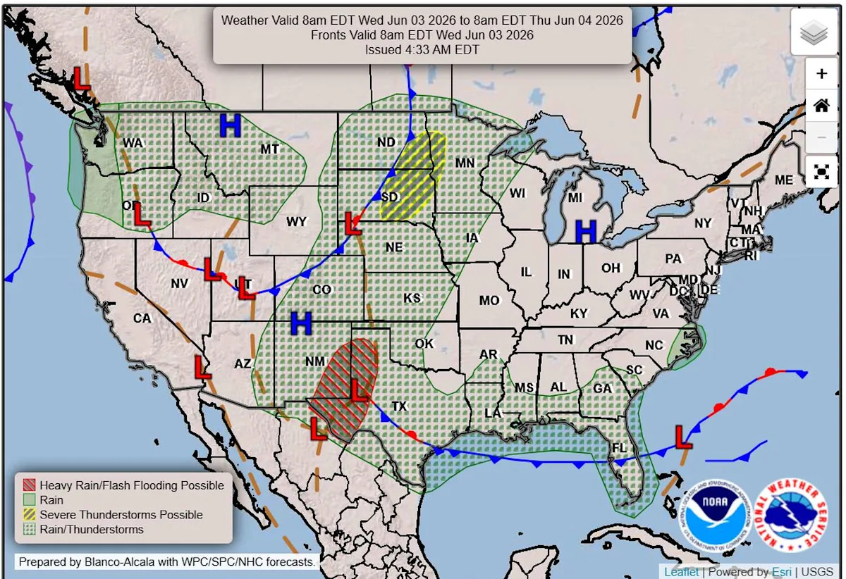
Active weather has returned to Central Texas after several days of hot, humid and largely dry conditions across the region.
Texas now sits between a ridge of high pressure to the east, producing clockwise flow, and a trough of low pressure to the west, generating counterclockwise flow. Together, this weather pattern is opening the door for tropical moisture to continue funneling northward from the Gulf, setting the stage for a more unsettled stretch of weather as several disturbances roll into Texas.
Wednesday will begin with a mix of sun and clouds, light east-to-northeast winds and temperatures in the mid-70s. By the afternoon, highs will climb into the upper 80s to low 90s as a nearby stalled frontal boundary becomes a focus for scattered showers and thunderstorms near Austin.
Farther west, the dry line across West Texas may also help spark storm development, placing Central Texas between two potential weather triggers and keeping scattered storm chances in the forecast through the late afternoon and evening.
Thursday will bring a similar setup, with muggy conditions starting in the low 70s before temperatures warm into the upper 80s during the afternoon. Scattered showers and thunderstorms will again be possible, particularly during the late afternoon and evening. While most locations are expected to see less than a quarter inch of rainfall, isolated pockets of heavier rain could produce quick, heavy downpours.
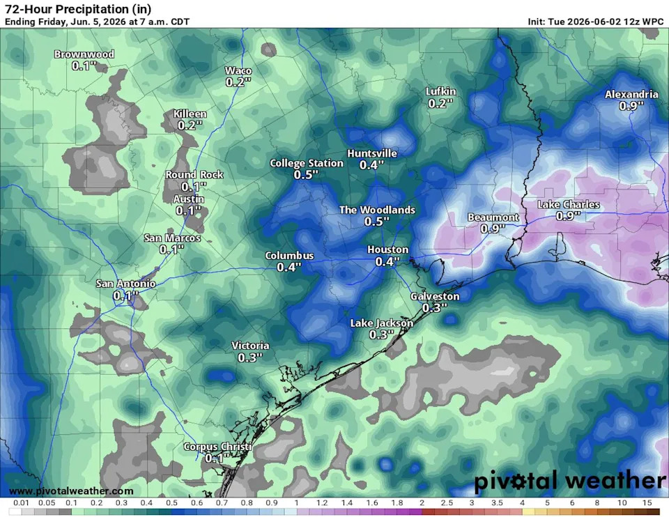
Rain totals will remain less than 0.25 inches of rain with isolated amounts up to 1 inch through Thursday night. (Pivotal)
On Friday, the attention turns to an upper-level low near Baja California that will move into Texas through the weekend. As it approaches, deep tropical moisture streaming northward from the Gulf will interact with the system, resulting in a more moisture-rich atmosphere and increasing the potential for heavy rainfall.
While forecast rainfall totals may exceed 2 inches in some areas, that does not mean everyone will receive that amount of rain. Instead, rainfall will vary from one location to another, with pockets of heavy rain capable of producing localized totals of 2 inches or more. The Weather Prediction Center is highlighting this potential for heavy rain and has painted most of Central Texas with a level 1 out of 4 marginal risk of flooding from Thursday through Saturday.
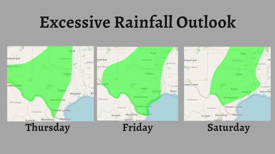
Moderate to heavy rainfall is possible across the areas shaded in green through Saturday. Localized flooding may develop anywhere within the highlighted region, especially where heavier downpours persist. (Weather Prediction Center)
“While the location and form of potential rains during this time period is uncertain this far in advance, storms that develop in the forecast environment could have the potential to produce torrential rainfall,” meteorologists at the Austin and San Antonio National Weather Service said. “Currently, the most favored period for heavy is Friday to Saturday, which is when the stream of deep tropical moisture is most likely to be centered over our area.”
Temperatures will remain warm and seasonable with high temperatures on either side of 90 degrees.
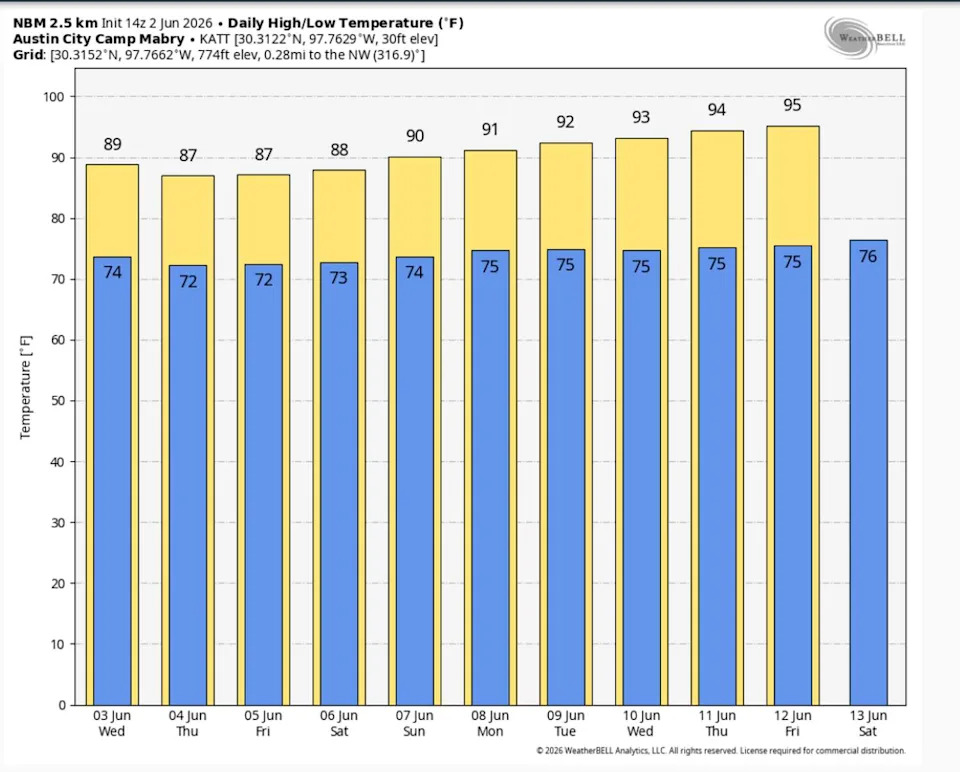
Average temperatures for early June are around 90 degrees for highs and 70 degrees for lows. Forecast temperatures through the remainder of the week are expected to stay close to those seasonal averages. (WeatherBell)
Welcome to Atlantic Hurricane Season
June also signals the official start of the Atlantic hurricane season, which runs through Nov. 30, peaking on Sept. 10. This year, activity in the Atlantic is more likely to be below normal, while activity in the eastern Pacific is more likely to be above normal.
While tropical activity in the Atlantic usually remains limited early in the season, forecasters still monitor the Gulf Coast and Southeast coastline for “homegrown” tropical disturbances. These storms can form close to the United States, organize quickly and occasionally bring tropical rainfall or coastal impacts with little lead time or warning.
HURRICANE SEASON: Atlantic hurricane season forecast to be milder than normal thanks to El Niño
Meanwhile, the eastern Pacific hurricane season, which began in mid-May, is already underway. Early-season tropical disturbances in the Pacific are common, and forecasters at the National Hurricane Center are monitoring an area that could develop into a tropical cyclone over the next few days.