
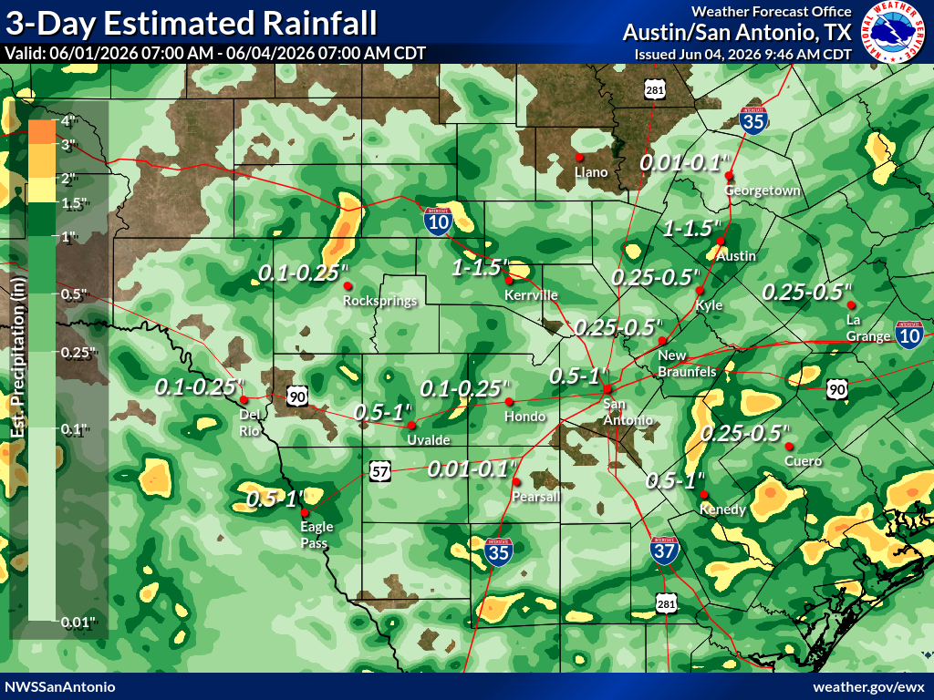
Pockets of heavy rain have fallen over Central Texas with some isolated areas recording over 2 inches of rain.
National Weather Service
What a treat we’ve had so far this month with over 2 inches of rain in the first week across parts of Central Texas. Officially, the Austin-Bergstrom International Airport has recorded 1.48 inches of rain, and the downtown location has picked up a little less at 1.30 inches, but both locations have a surplus of between 0.75 and 1 inch.

The latest outlook from the Climate Prediction Center shows wetter-than-normal conditions through the middle of the month.
Article continues below this ad
The wet weather pattern is expected to persist through mid-June, with above-normal rainfall chances continuing through June 17.
Climate Prediction Center
Rain and thunderstorms will remain through Friday and Saturday, with pockets of heavy rainfall possible, like what we’ve seen over the past several days. However, storm coverage should become more organized as an upper-level low moves into Texas from northern Mexico.
The weekend won’t be a washout, but be prepared for scattered thunderstorms capable of producing a quick 1 to 2 inches of rain. With recent rainfall leaving the ground saturated, it won’t take much additional rain to trigger localized flooding. That’s why the Weather Prediction Center has highlighted the region with a Level 1 out of 4 flood risk.
Heavy rain could produce localized flooding on Friday and Saturday. The Weather Prediction Center has a level 1 out of 4 flooding risk both days.
Weather Prediction Center
Timing of storms on Friday
Friday morning will be mainly dry in Central Texas except for some light showers or sprinkles. The cluster of storms that developed overnight in West Texas will be losing steam as it moves east into the Hill Country. Temperatures will be warm and muggy, in the low 70s.
Article continues below this ad
Light sprinkles or brief showers will be possible Friday morning, but the heavier rain is expected to remain west of the area for a few more hours.
Pivotal
As the atmosphere warms through the morning, instability will increase, allowing isolated showers and thunderstorms to develop shortly after lunchtime before becoming more widespread during the afternoon. Temperatures will climb into the mid- to upper 80s by 3 p.m.
“As the upper low slowly moves eastward during the daytime hours on Friday, some additional lift will move across the region in the southwesterly flow aloft,” meteorologists at the Austin and San Antonio National Weather Service wrote in their weather bulletin. “This will aid in rain chances expanding eastward across the remainder of south-central Texas, especially during the peak heating hours.”
Article continues below this ad
Scattered rain and thunderstorms are likely with some storms producing heavy rain and gusty winds.
Pivotal
The best chance for stronger storms and heavier downpours will be during the late afternoon and evening. With that said, if you have date-night plans, be sure to pack an umbrella. The good news is that widespread severe weather is not expected, although some storms could produce gusty winds up to 40 mph, frequent lightning and heavy rainfall.
Storms continue through the late evening before wrapping up during the overnight period.
Pivotal
The storms will continue until around midnight, but with the loss of heating and instability, they will begin to weaken.
Article continues below this ad
Saturday and Sunday forecast
The upper-level low will finally begin lifting northward across West Texas on Saturday. Moisture levels will remain high across the region, and another round of scattered afternoon and early evening thunderstorms is expected.
By Sunday, the weather system responsible for the recent rounds of rain will lift north of Central Texas, resulting in lower storm chances, especially east of Interstate 35. Temperatures will remain seasonable, with highs ranging from the mid-80s to around 90 degrees.
Article continues below this ad
We will return to a more typical summer weather pattern next week as the subtropical ridge begins to build over Texas. As a result, temperatures will climb back into the 90s.
Temperatures will remain below normal this weekend as clouds and scattered rain showers linger across the region. Once the wet weather moves out, a return to summer heat is expected, with highs climbing back into the 90s next week.
WeatherBell