
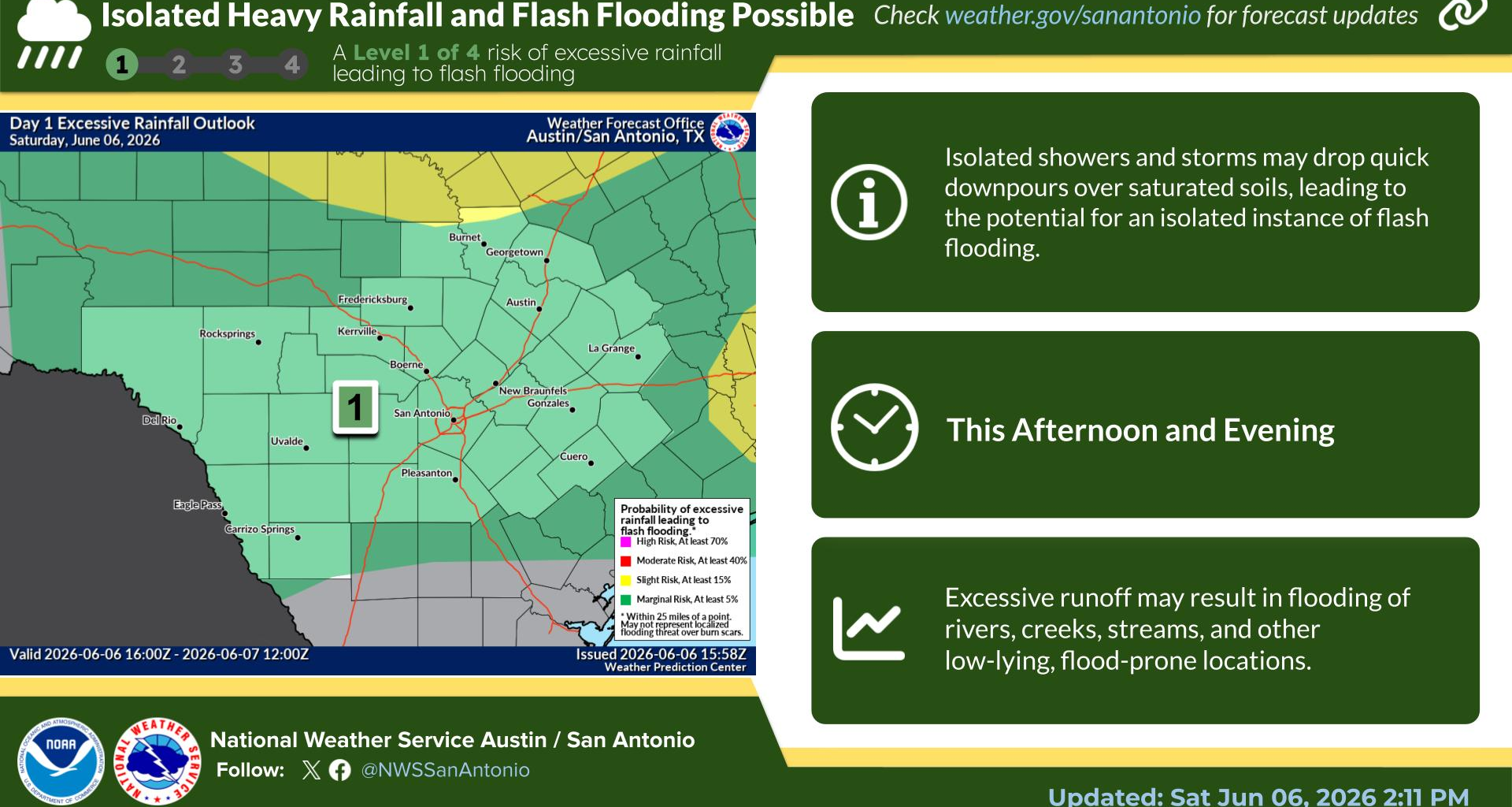
Excessive Rainfall Saturday
Today
Tonight
Weekly Outlook
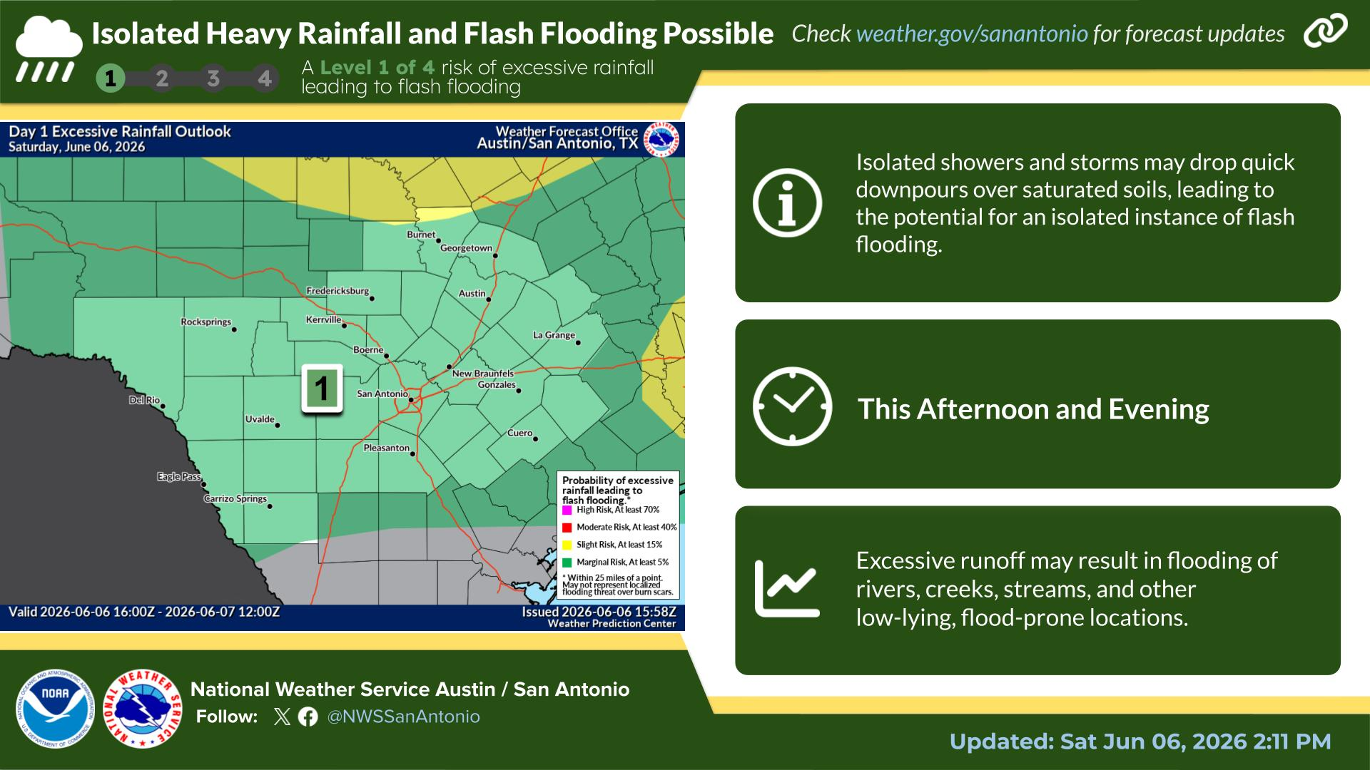
Low chances for showers and thunderstorms continue today into this evening, but any storms that do form could produce locally heavy rainfall. After heavy rain on previous days any additional rain will increase the likelihood of flooding. Stay weather aware.
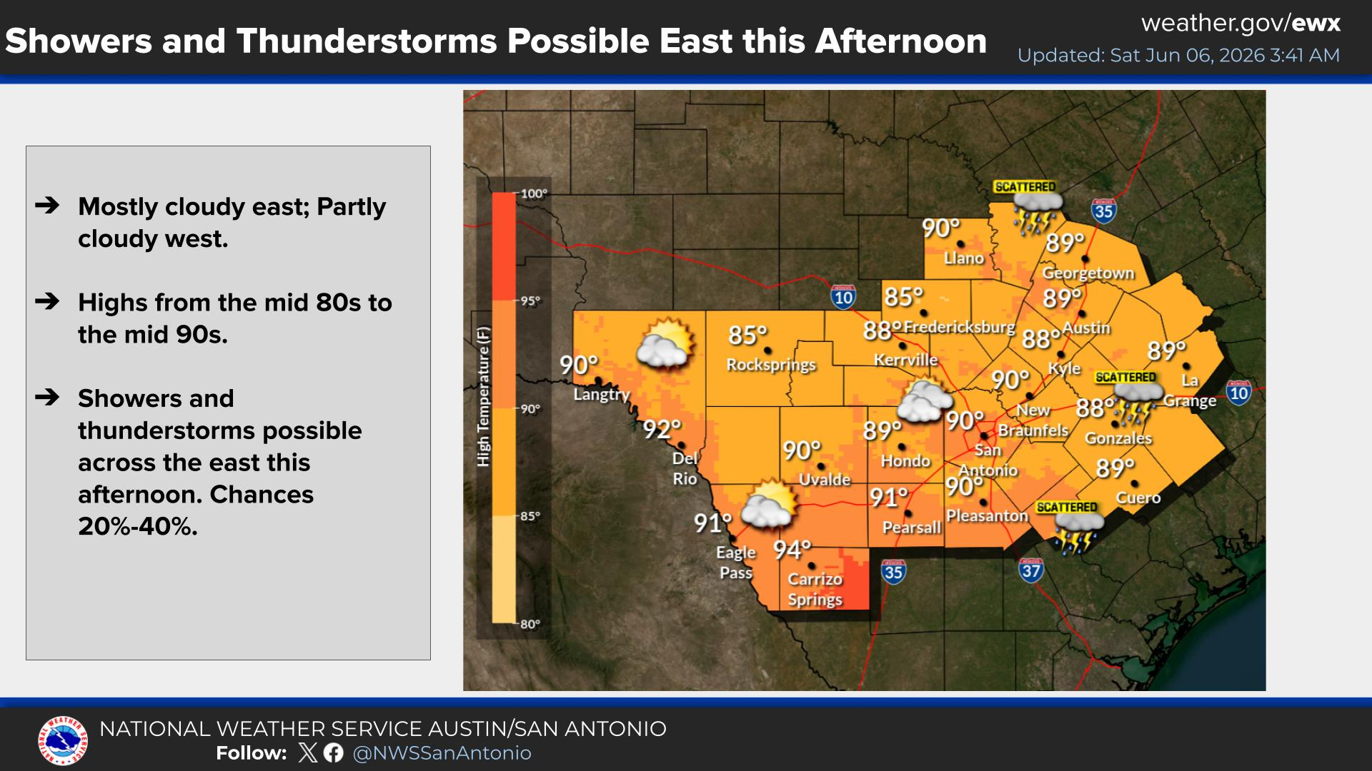
Today will be partly to mostly cloudy. There will be a chance for showers and thunderstorms over the eastern part of South-Central Texas. High temperatures will range from the mid 80s to the mid 90s.
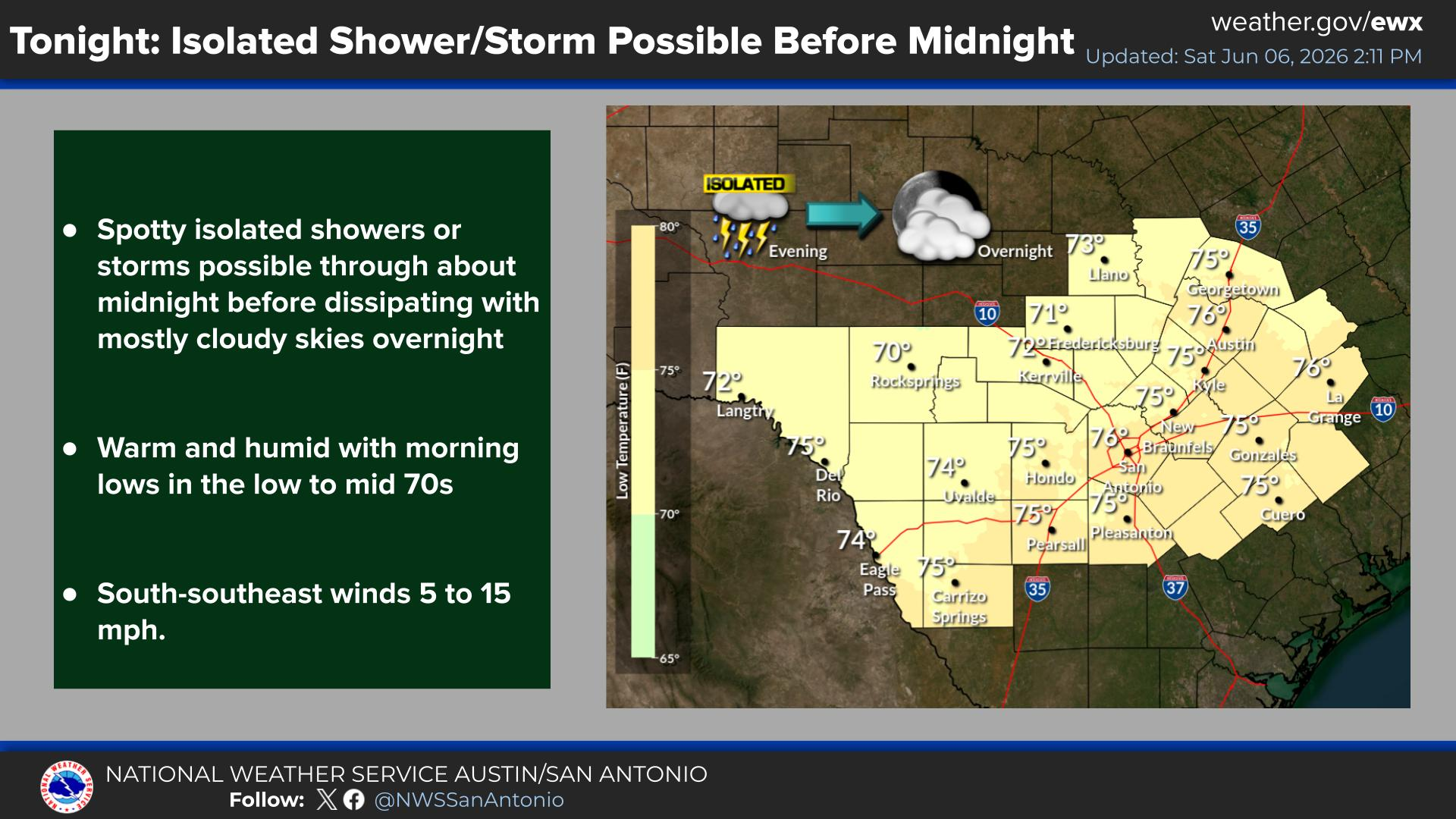
Spotty, isolated showers or storms are possible through about midnight tonight before dissipating. Skies will remain mostly cloudy overnight, keeping conditions warm and humid with morning low temperatures in the low-to-mid 70s. Winds will prevail from the south-southeast at 5 to 15 mph.
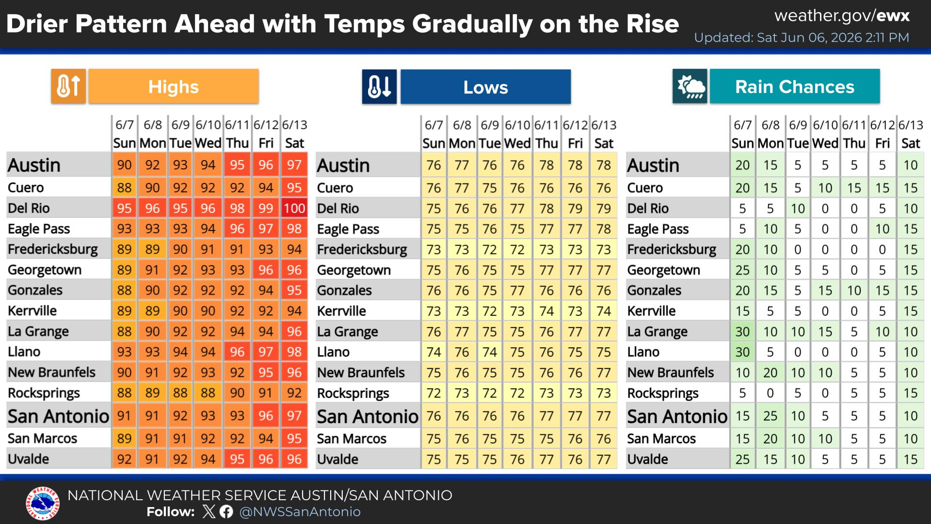
A much drier weather pattern settles into the region for the upcoming week, causing temperatures to steadily rise each day. Afternoon highs will climb from the upper 80s and low 90s on Sunday into the mid-to-upper 90s by Friday and Saturday, with Del Rio hitting 100°F. Low rain chances linger Sunday before dropping next week, remaining at 10% or less for most areas through the week.
Latest NWS Austin/San Antonio Text Products Public Information Statement (PNS)KEWX (New Braunfels) Radar Message (FTM)KDFX (Del Rio) Radar Message (FTM)KGRK (Granger) Radar Message (FTM) Area Forecast Discussion (AFD)Zone Forecast (ZFP)Tabular State Forecast (SFT)Point Forecast Matrices (PFM)Short Term Forecast (NOW) Hourly South Central Texas Regional Weather Roundup (RWR)Miscellaneous Hydrologic Data (RRM)Local Cooperative Observations (LCO)Local Storm Report (LSR) Austin Bergstrom Int’l Airport (AUS) Daily Climatological Report (CLI)Austin Bergstrom Int’l Airport (AUS) Monthly Climatological Report (CLM)Austin Bergstrom Int’l Airport (AUS) Preliminary Local Climatological Data (CF6)Austin Bergstrom Int’l Airport (AUS) Record Event Report (RER)Austin Camp Mabry (ATT) Daily Climatological Report (CLI)Austin Camp Mabry (ATT) Monthly Climatological Report (CLM)Austin Camp Mabry (ATT) Preliminary Local Climatological Data (CF6)Austin Camp Mabry (ATT) Record Event Report (RER)Del Rio Int’l Airport (DRT) Daily Climatological Report (CLI)Del Rio Int’l Airport (DRT) Monthly Climatological Report (CLM)Del Rio Int’l Airport (DRT) Preliminary Local Climatological Data (CF6)Del Rio Int’l Airport (DRT) Record Event Report (RER)San Antonio Int’l Airport (SAT) Daily Climatological Report (CLI)San Antonio Int’l Airport (SAT) Monthly Climatological Report (CLM)San Antonio Int’l Airport (SAT) Preliminary Local Climatological Data (CF6)San Antonio Int’l Airport (SAT) Record Event Report (RER) Hydrologic Statement (RVS)Hydrologic Summary (RVA)Flood Statement (FLS)Flood Warning (FLW)Flood Watch (FFA) Flash Flood Statement (FFS)Flash Flood Warning (FFW)Special Weather Statement (SPS)Severe Thunderstorm Warning (SVR)Severe Weather Statement (SVS)Tornado Warning (TOR)Watch County Notification Message (WCN)Non-Precipitation (NPW)Winter Weather (WSW)Air Quality Alert (AQA) Austin Bergstrom Int’l (AUS) Airport Weather Warning (AWW)Austin Bergstrom Int’l Airport (AUS) Terminal Aerodrome Forecast (TAF)San Antonio Int’l (SAT) Airport Weather Warning (AWW)San Antonio Int’l Airport (SAT) Terminal Aerodrome Forecast (TAF)Stinson Municipal Airport (SSF) Terminal Aerodrome Forecast (TAF)Del Rio Int’l Airport (DRT) Terminal Aerodrome Forecast (TAF) Fire Weather Planning Forecast (FWF)Fire Weather Point Forecast Matrices (PFW)Fire Weather Spot Forecast (FWS)Fire Danger Statement (RFD)Red Flag Warning (RFW)Drought Information Statement (DGT) Hurricane Local Statement (HLS)Tropical Cyclone Watch/Warning (TCV)Post Tropical Cyclone Report (PSH) Rawinsonde Freezing Level Data (FZL)Rawinsonde Observation Mandatory Levels (MAN)Rawinsonde Observation Significant Levels (SGL)Rawinsonde Data Above 100 Millibars (ABV) Child Abduction Emergency (CAE)Civil Emergency Message (CEM)Fire Warning (FRW)911 Telephone Outage Emergency (TOE)