
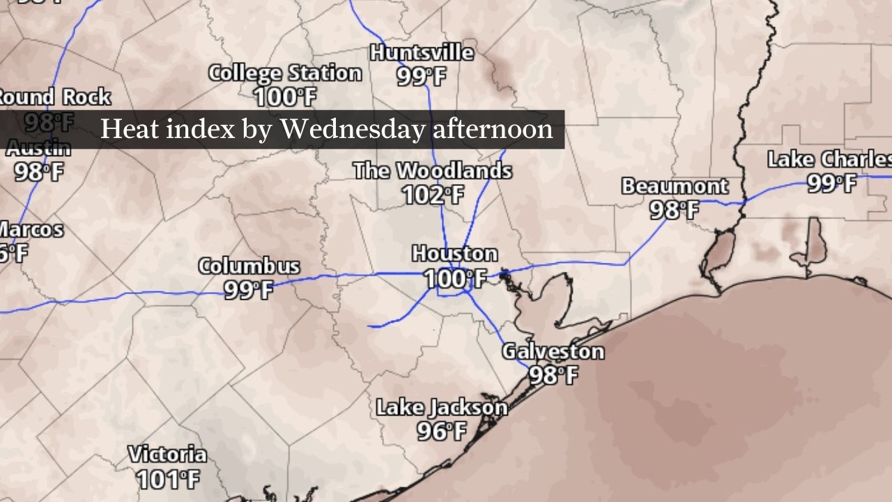
Southeast Texas will heat up this week as rain chances drop. Heat index values by Wednesday could approach 100 degrees, as shown by this map.
Pivotal Weather
After a soggy start to June, Houston’s weather is about to feel a lot more like summer.
A drier pattern is expected to settle across Southeast Texas this week as widespread rain chances diminish and temperatures steadily climb. While an isolated afternoon thunderstorm remains possible, the bigger story will be increasing heat and humidity that could push heat index values above 100 degrees by the weekend.
How hot Houston could get this week
Temperatures will gradually climb throughout the week as a strengthening area of high pressure limits storm coverage across the region.
Article continues below this ad
Highs are expected to reach the upper 80s and low 90s through the first half of the week before climbing into the mid-90s by Saturday. That’s a few degrees above normal for this time of year and will mark a noticeable change from the cooler, rain-cooled conditions many areas experienced recently.
ROADMAP OF CLOUDS: Cloud formations appeared to reflect Houston’s freeways one morning last week. Here’s why.
Houston is not currently expected to reach 100 degrees this week, but it may feel close.
Humidity will remain high, thanks to persistent southerly winds off the Gulf pushing heat index values to around 100 degrees early in the week and into the middle and upper 100s by late week. If that trend continues, heat advisories could become necessary by the weekend.
Article continues below this ad
For residents looking to escape the heat at the beach, caution will still be needed. Persistent onshore winds are expected to maintain an elevated risk of rip currents along the Gulf Coast through much of the week. Beachgoers should swim near lifeguards when available and pay attention to local beach safety flags and warnings.
Rain chances drop as flood risk fades
The shift toward hotter weather comes as Southeast Texas moves away from the active pattern that brought heavy rainfall and localized flooding to parts of the region.
Scattered afternoon showers and thunderstorms remain possible most days, especially as the sea breeze moves inland. Any stronger storm could still produce brief heavy rainfall because abundant moisture remains in place.
Rainfall through the next seven days will primarily be confined to areas of North Texas and the Piney Woods. Closer to Houston, rain will be harder to come by.
NOAA’s Weather Prediction Center / Pivotal Weather
However, storms are expected to be much more isolated than they were during the past week, and the overall threat of widespread flooding has diminished considerably.
Article continues below this ad
A few locations could still experience temporary street flooding or ponding, particularly in areas that have received repeated rounds of rain recently, but most communities should see a quieter stretch of weather.
Houston heat to last beyond sunset
The heat won’t be confined to the daytime hours.
Overnight lows are expected to remain in the upper 70s to around 80 degrees throughout the week, limiting opportunities for meaningful cooling after sunset.
Heat index values even at night aren’t likely to drop much below 80 degrees, as shown by this map of forecast heat index values early Thursday morning across Southeast Texas.
Pivotal Weather
That may sound manageable compared to afternoon temperatures in the 90s, but warm nights can make hot weather more difficult to tolerate because homes, roads and buildings have less time to release heat accumulated during the day. The result is muggy mornings and a gradual buildup of heat stress over several days.
Article continues below this ad
HOUSTON WEATHER [SIMPLIFIED]: Sign up for texts to get forecasts and extreme weather alerts on your phone.
High humidity will also play a role. Moist air and overnight cloud cover can act like a blanket, trapping heat near the surface and preventing temperatures from falling very far overnight.
For many residents, the combination of increasingly hot afternoons and limited nighttime relief may be the most noticeable weather change this week.