
The National Hurricane Center’s seven-day tropical weather outlook highlights an area in the Gulf of Mexico’s Bay of Campeche where a broad area of low pressure could develop during the next seven days. The disturbance has a low chance of tropical development.
National Hurricane CenterA tropical disturbance in the Bay of Campeche has a 10% chance of development over the next week, with near-zero odds in the next 48 hours.The system is expected to move inland across eastern Mexico late this weekend, limiting its potential to strengthen over water.Moisture from the disturbance could increase rain chances in Southeast Texas late this weekend and early next week.
A tropical disturbance is expected to develop in the Gulf of Mexico’s Bay of Campeche later this week. Although it is unlikely to become a significant tropical threat, it could bring higher rain chances to Southeast Texas heading into next week.
The westward-moving tropical wave of low atmospheric pressure could form into a broader area, the National Hurricane Center said Wednesday. forecasters give it a 10% chance of development during the next seven days, with near-zero odds through the next 48 hours.
Article continues below this ad
The disturbance is forecast to move inland across eastern Mexico late this weekend, limiting its ability to organize over water. Is a tropical cyclone forming in the Gulf of Mexico? Almost certainly, it is not.
IS YOUR NAME ON THE LIST? : These are the hurricane names for the 2026 season and why ‘Melissa’ is retired from it.
Could Arthur form?
The likelihood that the disturbance becomes Arthur, the first name on the 2026 Atlantic hurricane season list, is even lower. An area of low atmospheric pressure area might develop over the next several days, but atmospheric conditions are not expected to support significant strengthening as it nears eastern Mexico.
Even if a low pressure system forms, forecasts indicate it will move inland before it has much opportunity to strengthen. Nothing indicates that the disturbance will become a significant tropical threat.
Article continues below this ad
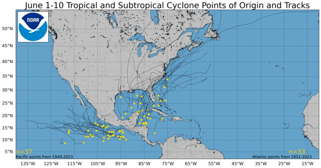
Shown are historical points where tropical development has occurred across the Atlantic and Pacific basin from June 1-10. Common hotspots for tropical development are found in the Gulf of Mexico, off the southeast coast of the United States, and in the northwestern Caribbean.
National Hurricane Center
Shown are historical points where tropical development has occurred across the Atlantic and Pacific basin from June 11-20. Common hotspots for tropical development are found in the Gulf of Mexico and the northwestern Caribbean.
National Hurricane Center
Shown are historical points where tropical development has occurred across the Atlantic and Pacific basin from June 21-30. Common hotspots for tropical development are found in the Gulf of Mexico and off the southeast coast of the United States.
National Hurricane Center
Will the disturbance affect Houston?
While the disturbance is not expected to move toward Texas, with current forecasts showing it heading inland across eastern Mexico late this weekend, Southeast Texas could still feel indirect effects. Moisture associated with the disturbance could spread northward late this weekend and early next week, increasing rain chances across the region.
Some locations could see periods of locally heavy rainfall, but it remains too early to determine rainfall totals or where the heaviest rainfall could occur.
Why does the Bay of Campeche matter in June?
The Bay of Campeche is one of the first places to watch during the opening weeks of Atlantic hurricane season.
Article continues below this ad
Disturbances frequently develop there in June, taking advantage of warm Gulf waters before moving inland over Mexico. That short window over water often limits development, which is one reason this system has such low odds of becoming a tropical cyclone.
The disturbance might also share roots with what was Tropical Storm Cristina in the eastern Pacific, which weakened into a depression Wednesday. Tropical waves of low pressure can occasionally influence weather on both sides of Mexico, though the systems themselves remain separate.
FEWER STORMS: A quieter hurricane season is taking shape for Texas. Don’t let that fool you.
Even when development is limited, southwestern Gulf disturbances can still pull tropical moisture northward. For Southeast Texas, the more relevant question is not whether this becomes Arthur, but whether it increases rain chances heading into next week.
What should Southeast Texas residents watch for?
At this point, the disturbance is not a cause for concern in Southeast Texas.
Article continues below this ad
The disturbance does not currently pose a direct tropical threat to Southeast Texas, and development odds remain low. The main forecast aspect to watch is whether moisture associated with the system increases rain chances across the region late this weekend and early next week.
This forecast map shows tropical moisture spreading northward across the western Gulf of Mexico by early next week. Shades of pink indicate deeper volumes of moisture that could increase rain chances across Southeast Texas.
Pivotal Weather
Forecast confidence remains highest that the disturbance will move into eastern Mexico. Confidence is lower regarding how much rainfall Southeast Texas may receive and where the heaviest rain could occur.
Residents should continue monitoring forecasts through the weekend as details become clearer.
Article continues below this ad