
El Niño has officially arrived, according to the National Oceanic and Atmospheric Administration’s Climate Prediction Center – and that could be good news for Austin and the Texas Gulf Coast with hurricane season now underway.
El Niño conditions have developed over the past month and are expected to strengthen into the rest of the year, forecasters said on the Climate Prediction Center’s web site. Here’s what we know so far:
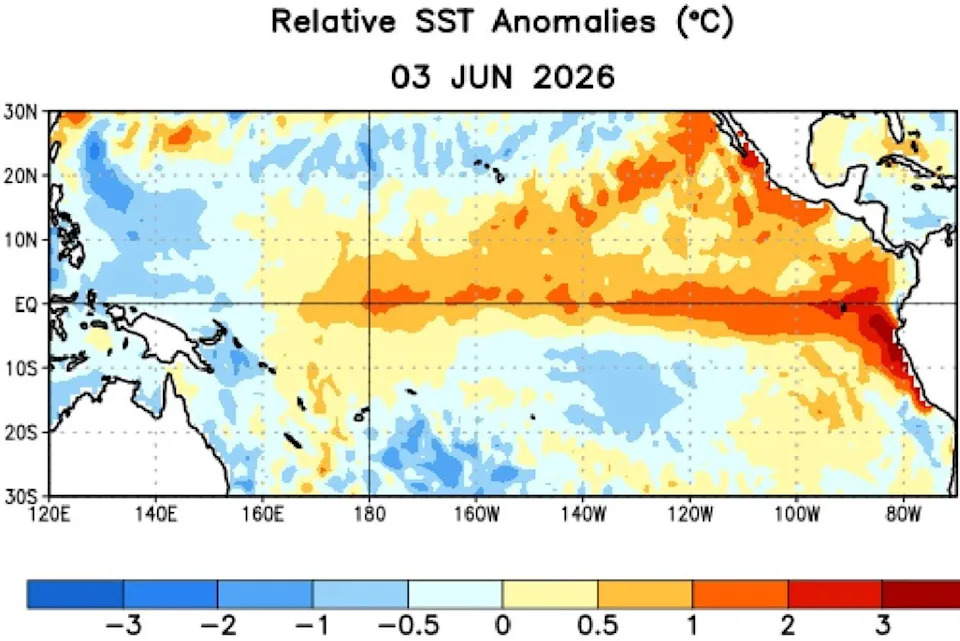
This map of sea-surface temperature anomalies in the Pacific Ocean, as of June 3, shows that the tropical waters of the eastern Pacific are warmer than the long-term average, indicating the presence of El Niño. (Climate Prediction Center/National Oceanic and Atmospheric Administration)
What is El Niño?
El Niño is not a storm nor is it a single weather event, like a freeze or a heat wave. It is a naturally occurring but relatively infrequent event that happens when the equatorial waters of the eastern Pacific Ocean become warmer than normal.
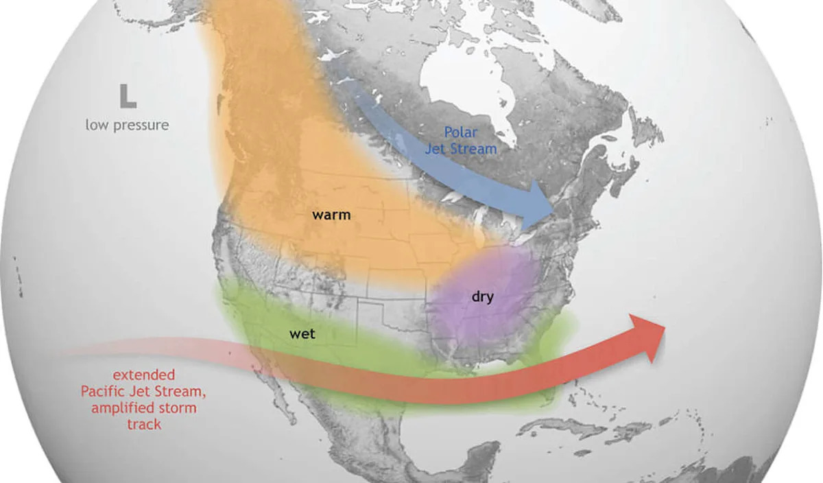
The phenomenon results in a significant transfer of heat energy in the world’s largest ocean, so it ends up influencing weather patterns globally. In Texas, particularly in the fall and winter, El Nino tends to produce wetter and cooler weather than normal.
El Nino officially arrives when sea-surface temperatures in the tropical waters of the eastern Pacific exceed the long-term average by 0.5 degrees Celsius. The latest El Nino index reading this month shows temperatures 0.7 degrees Celsius higher than normal.
What does El Niño mean for Texas weather?
Typically, El Niño has its biggest effect on Texas during the winter months, as the Pacific jet stream becomes stronger and shifts closer to Texas. This leads to more frequent cold fronts and a more active storm track across the southern United States, resulting in cooler and wetter weather across the Lone Star State.
But since 1950, the Northern Hemisphere has had 16 summers when El Niño was active. During those years, El Niño summers in Houston averaged about a half-degree warmer than normal, while rainfall was even more noticeably reduced, with 23% less rainfall observed during El Niño summers.
In San Antonio, the city’s average summertime high temperature was 94.9 degrees – about a half-degree warmer than in non-El Niño summers. Of those 16 El Niño summers analyzed, nine produced above-average temperatures, three were near-average, and four years resulted in below-average temps. San Antonio also has averaged only 7.05 inches of rain during El Niño summers, which is 12.4% drier than non-El Niño summers.
However, the pattern is not consistent across the entire state. In Austin, the effects have been much less pronounced. Temperatures during El Niño summers have averaged just 0.3 degree warmer than normal, while rainfall totals have been nearly identical to the long-term average.
Across North and West Texas, historical weather data shows little difference in summertime weather during El Niño years. Both Dallas and Lubbock have seen almost no change in average temperatures or precipitation when El Niño is active.
What does El Niño mean for hurricane season?
El Niño’s influence can extend far beyond the Pacific by increasing upper-level winds across the Caribbean and tropical Atlantic. Those stronger winds create vertical wind shear, a change in wind speed or direction with altitude. In practical terms, shear can tilt a developing storm, disrupt its thunderstorms and prevent the system from organizing vertically. Hurricanes need a relatively calm column of air above them to strengthen efficiently.
That is why a moderate to strong El Niño often works against Atlantic hurricane development.
On Wednesday, researchers at Colorado State University, whose annual hurricane season forecasts are nationally recognized and highly trusted, have revised downward their 2026 projections because of El Niño. The CSU team is now calling for only 11 named storms, down from 13 in its original forecast in April. The forecast is broadly in line with NOAA’s own outlook released in late May, which also projects a below-normal Atlantic hurricane season because of El Niño.
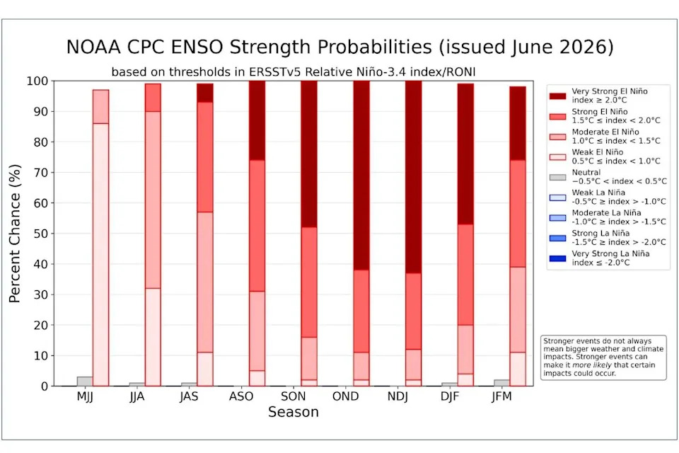
NOAA’s Climate Prediction Center forecasts show El Niño continuing to strengthen through the fall and winter months. (Climate Prediction Center/National Oceanic and Atmospheric Administration)
How long will El Niño last?
Climate Prediction Center forecasts show El Niño continuing to strengthen through the fall and winter months, which means the rest of 2026 and at least the first two months of 2027. The chances of a “very strong” El Niño – when mean sea-surface temperatures rise to more than 2 degrees Celsius above average – are expected to rise over the summer and into the winter months.
For instance, during the months of August, September and October, when Atlantic hurricane activity has been the strongest and most intense, forecasters are calling for about a 25% chance of a “very strong” El Niño.
The chances of a “very strong” El Niño rise as high as 63% during the months of November, December and January, a probability figure that could put this event among the largest El Niño events in the historical record going back to 1950, according to the Climate Prediction Center.
This article originally published at El Niño has officially arrived. Here’s what it means for Austin and Texas summer weather.