
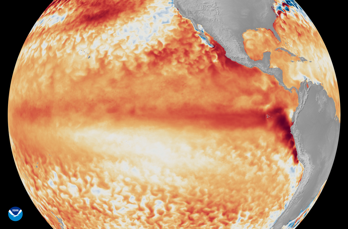
Satellite imagery from the first week of June shows average sea-surface temperatures at the equator in the tropical Pacific Ocean are warmer than average (seen as various shades of red and orange). This level of warmth means El Niño status has officially been reached.
NOAA Satellites
According to the National Weather Service’s update on Thursday, El Niño conditions are now present over the eastern Pacific Ocean near the equator, and an El Niño advisory has been issued.

For El Niño to officially develop, sea-surface temperatures in the eastern equatorial Pacific Ocean must be at least 0.5 degree Celsius warmer than the long-term average. As of Thursday, temperatures in that region were already 0.7 degree above average, meaning that El Niño status has officially been reached.
Article continues below this ad
The weather agency’s update also noted “anomalously high oceanic heat content” within the eastern Pacific, which is a good indicator that El Niño is likely to strengthen significantly in the coming months.
By late fall and winter, the update now calls for a 63% chance of a “very strong” El Niño, also known as a “super” El Niño. To meet that threshold, sea-surface temperatures would need to rise to more than 2 degrees Celsius above average. That has happened only six times since 1950, most recently in 2024.
What does El Niño mean for Texas?
While sea-surface temperatures thousands of miles away may seem arbitrary, this shifting of heat energy in the world’s largest ocean plays a major role in shaping global atmospheric circulation patterns.
Article continues below this ad
During an El Niño, the upper-atmospheric jet stream over the Pacific becomes stronger and moves closer to Texas. This leads to more frequent cold fronts and a more active storm track across the southern United States.
For Texas, El Niño’s most noticeable effects typically occur during the late fall and winter months, as it typically brings cooler and wetter weather statewide.
El Niño causes a southward shift in the polar jet stream. In the wintertime, the polar jet stream can interact with Gulf of Mexico moisture, causing cooler and wetter weather throughout the state.
NOAA/National Weather Service
Historically, El Niño winters in San Antonio have resulted in average wintertime temps 1.4 degrees colder than non-El Niño winters. However, the effect on precipitation is much more drastic. San Antonio averages 6.68 inches of rain during El Niño winters, a 58% increase compared to non-El Niño winters.
Article continues below this ad
If “super El Niño” status is reached, it does not necessarily mean the effects will be stronger. Instead, it increases the likelihood that Texas will experience weather patterns typically associated with El Niño.
Any summer effects?
While the most significant impacts of El Niño are not expected until winter, some evidence shows that summer weather can also be affected, particularly across Central and South Texas.
Since 1950, the Northern Hemisphere has experienced 16 summers with active El Niño conditions. During those years, San Antonio’s average summertime high temperature was 94.9 degrees — about a half-degree warmer than non-El Niño summers. Similar differences were also observed in Austin and Houston.
Article continues below this ad
San Antonio also has averaged only 7.05 inches of rain during El Niño summers, which is 12.4% drier than non-El Niño summers.
While the differences in the data are not dramatic, the numbers suggest that a summertime El Niño slightly favors warmer and drier conditions in San Antonio. That’s the opposite of its typical wintertime effects, which tend to bring cooler and wetter weather.
NOAA’s 2026 Atlantic hurricane season outlook projects below-average tropical activity, mostly because of an expected El Niño, which has now developed in the eastern Pacific.
NOAA
The presence of an El Niño has also been known to limit Atlantic hurricane activity by strengthening upper-level winds across the Caribbean Sea and tropical Atlantic Ocean. These stronger winds create wind shear, which can disrupt developing tropical systems and make it more difficult for hurricanes to organize and intensify.
Article continues below this ad
Because of the developing El Niño, the National Weather Service is expecting a below-average Atlantic hurricane season. In its forecast released in May, between three and six hurricanes are expected to develop during the season, less than the long-term average of seven per year.