
The National Hurricane Center continues to track a system sitting over South Texas and the Gulf, and has upgraded it to Potential Tropical Cyclone One on Tuesday. PTC1 is producing a large area of disorganized showers and thunderstorms. It’s located about 65 miles southwest of Corpus Christi. The system is moving toward the northeast at 6 mph, and this general motion with an increase in forward speed is anticipated over the next couple of days. The disturbance should move offshore the Texas coast tonight or early Wednesday, move roughly parallel to the upper Texas coast later on Wednesday and move back inland in extreme eastern Texas or southwestern Louisiana late Wednesday or early Thursday.Maximum sustained winds are near 30 mph with higher gusts. The estimated minimum central pressure is 1007 mb. RESOURCES | HURRICANE SUPPLIES | SURVIVAL GUIDE | HURRICANE SEASON SPECIAL | WESH LONG-RANGE FORECAST | WHAT TO KNOW ABOUT INSURANCE | GENERATOR SETUP | TESTING CHAINSAWS | POST-STORM RESOURCES | DOWNLOAD WESH 2 APP The disturbance is forecast to gradually strengthen and could become a tropical storm early on Wednesday. Weakening is anticipated on Thursday after the system moves back on land.Formation chance through 48 hours: 60%Formation chance through 7 days: 60%A tropical storm watch has been issued for the northwestern Gulf Coast from Sargent, Texas to Morgan City, Louisiana.Impacts Rainfall totals of 4 to 8 inches with isolated higher totals around 12 inches are possible through Thursday from the Mid to Upper Texas Coast through much of Louisiana, central and southern portions of Mississippi and Alabama, and the far western portion of the Florida Panhandle. A tornado or two is possible through tonight from the Upper Texas coast across southern Louisiana, Mississippi, Alabama and the Florida Panhandle.If it were to become a named storm, it would be called Arthur. Tracking the TropicsStay with WESH 2 online and on-air for the most accurate Central Florida weather forecast.RadarSevere Weather AlertsDownload the WESH 2 News app to get the most up-to-date weather alerts.The First Warning Weather team includes First Warning Chief Meteorologist Tony Mainolfi, Eric Burris, Marquise Meda, Cam Tran and Victoria Wisniewski.>> 2026 hurricane season | WESH long-range forecast>> Download Very Local | Stream Central Florida news and weather from WESH 2
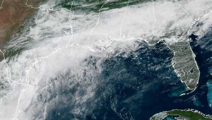
The National Hurricane Center continues to track a system sitting over South Texas and the Gulf, and has upgraded it to Potential Tropical Cyclone One on Tuesday.
PTC1 is producing a large area of disorganized showers and thunderstorms. It’s located about 65 miles southwest of Corpus Christi.
The system is moving toward the northeast at 6 mph, and this general motion with an increase in forward speed is anticipated over the next couple of days.
The disturbance should move offshore the Texas coast tonight or early Wednesday, move roughly parallel to the upper Texas coast later on Wednesday and move back inland in extreme eastern Texas or southwestern Louisiana late Wednesday or early Thursday.
Maximum sustained winds are near 30 mph with higher gusts. The estimated minimum central pressure is 1007 mb.
RESOURCES | HURRICANE SUPPLIES | SURVIVAL GUIDE | HURRICANE SEASON SPECIAL | WESH LONG-RANGE FORECAST | WHAT TO KNOW ABOUT INSURANCE | GENERATOR SETUP | TESTING CHAINSAWS | POST-STORM RESOURCES | DOWNLOAD WESH 2 APP
The disturbance is forecast to gradually strengthen and could become a tropical storm early on Wednesday.
Weakening is anticipated on Thursday after the system moves back on land.
Formation chance through 48 hours: 60%Formation chance through 7 days: 60%
A tropical storm watch has been issued for the northwestern Gulf Coast from Sargent, Texas to Morgan City, Louisiana.
Impacts
Rainfall totals of 4 to 8 inches with isolated higher totals around 12 inches are possible through Thursday from the Mid to Upper Texas Coast through much of Louisiana, central and southern portions of Mississippi and Alabama, and the far western portion of the Florida Panhandle.
A tornado or two is possible through tonight from the Upper Texas coast across southern Louisiana, Mississippi, Alabama and the Florida Panhandle.
If it were to become a named storm, it would be called Arthur.
This content is imported from Twitter.
You may be able to find the same content in another format, or you may be able to find more information, at their web site.
Tracking the Tropics
Stay with WESH 2 online and on-air for the most accurate Central Florida weather forecast.
Download the WESH 2 News app to get the most up-to-date weather alerts.
The First Warning Weather team includes First Warning Chief Meteorologist Tony Mainolfi, Eric Burris, Marquise Meda, Cam Tran and Victoria Wisniewski.
>> 2026 hurricane season | WESH long-range forecast
>> Download Very Local | Stream Central Florida news and weather from WESH 2